La Unión elevation
La Unión (Guerrero, La Unión de Isidoro Montes de Oca), Mexico elevation is 64 meters and La Unión elevation in feet is 210 ft above sea level [src 1]. La Unión is a seat of a second-order administrative division (feature code) with elevation that is 1250 meters (4101 ft) smaller than average city elevation in Mexico.
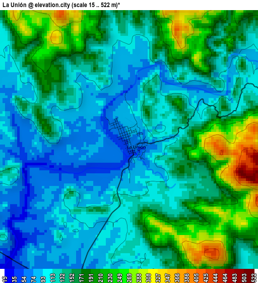
Below is the Elevation map of La Unión, which displays elevation range with different colors. Scale of the first map is from 15 to 522 m (49 to 1713 ft) with average elevation of 146.1 meters (=479 ft) [note 1]
These maps also provides idea of topography and contour of this city, they are displayed at different zoom levels. More info about maps, scale and edge coordinates you can find below images.
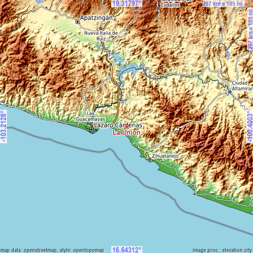
| \ | Map #1 | Topo.Map |
| Scale [m] | 15..522 m | × |
| Scale [ft] | 49..1713 ft | × |
| Average | 146.1 m = 479 ft | × |
| Width | 9.29 km = 5.8 mi | 297.4 km = 184.8 mi |
| Height | 9.3 km = 5.8 mi | 297.4 km = 184.8 mi |
| ↑Max Latitude | 18.027403° | 19.31797° |
| Latitude at center | 17.98561° | 17.98561° |
| ↓Min Latitude | 17.943807° | 16.64312° |
| ← Min Longitude | -101.850495° | -103.2128° |
| Longitude center | -101.80655° | -101.80655° |
| →Max Longitude | -101.762605° | -100.4003° |
Nearby cities:
Cities around La Unión sort by population:
• Ciudad Lázaro Cárdenas elevation 27 m
43.9 km,  267°
267°
• Guacamayas 25 m
43.1 km, 274°
• Ixtapa 10 m
39.4 km,  153°
153°
• San José Ixtapa (Barrio Viejo) 14 m
37.2 km, 147°
• Pantla 25 m
32.8 km, 146°
• Petacalco 10 m
31.9 km, 269°
• Infiernillo (Morelos de Infiernillo) 80 m
34.5 km,  343°
343°
• Barrio Nuevo 14 m
34.5 km, 148°
• Coahuayutla de Guerrero 313 m
37.3 km,  11°
11°
• Lagunillas 50 m
20.6 km, 150°
• Zacatula 16 m
39.5 km, 273°
• El Naranjito 12 m
37.1 km, 270°
Multilingual:
 En español:
La Unión elevación 64 m.
 En France:
La Unión élévation 64 m.


Sources and notes:
- [note 1] Map square and city borders are not equal. Map elevation data is calculated only from area inside that square.
- [src 1] Elevation data from geonames database provided with same terms of usage.
- [src 2] The elevation map of La Unión is generated using elevation data from NASA's 3 arcsec (90m) resolution SRTM data.
- [src 3] Base (background) map © OpenStreetMap contributors tiles are generated by Geofabrik and OpenTopoMap.
Copyright & License:
This La Unión Elevation Map is licensed under CC BY-SA. You may reuse any part from this page, if you give a proper credit by linking to this URL:
 More info on terms of use page.