Cuamio elevation
Cuamio (Michoacán, Cuitzeo), Mexico elevation is 1840 meters and Cuamio elevation in feet is 6037 ft above sea level [src 1]. Cuamio is a populated place (feature code) with elevation that is 526 meters (1726 ft) bigger than average city elevation in Mexico.
Below is the Elevation map of Cuamio, which displays elevation range with different colors. Scale of the first map is from 1830 to 2331 m (6004 to 7648 ft) with average elevation of 1883.5 meters (=6179 ft) [note 1]
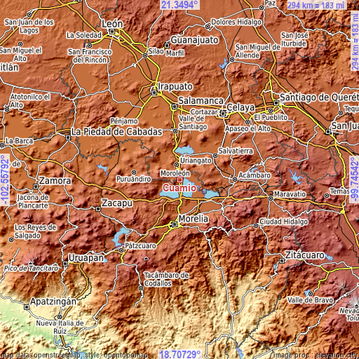
These maps also provides idea of topography and contour of this city, they are displayed at different zoom levels. More info about maps, scale and edge coordinates you can find below images.
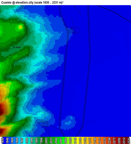
| \ | Map #1 | Topo.Map |
| Scale [m] | 1830..2331 m | × |
| Scale [ft] | 6004..7648 ft | × |
| Average | 1883.5 m = 6179 ft | × |
| Width | 9.18 km = 5.7 mi | 293.8 km = 182.6 mi |
| Height | 9.18 km = 5.7 mi | 293.8 km = 182.6 mi |
| ↑Max Latitude | 20.075181° | 21.3494° |
| Latitude at center | 20.0339° | 20.0339° |
| ↓Min Latitude | 19.992608° | 18.70729° |
| ← Min Longitude | -101.195615° | -102.55792° |
| Longitude center | -101.15167° | -101.15167° |
| →Max Longitude | -101.107725° | -99.74542° |
Nearby cities:
Cities around Cuamio sort by population:
• Uriangato elevation 1810 m
12.3 km,  344°
344°
• Moroleón 1815 m
11 km, 337°
• Cuitzeo del Porvenir 1845 m
7.1 km,  172°
172°
• Mariano Escobedo 1857 m
12.1 km,  129°
129°
• San Agustín del Pulque 1847 m
11.4 km, 134°
• San Juan Benito Juárez (San Juan Tararameo) 1846 m
13.2 km, 169°
• Capacho 1847 m
11.3 km,  227°
227°
• Cuaracurío 1839 m
3 km,  7°
7°
• San José Cuaro 1861 m
11.6 km,  244°
244°
• Rinconadas del Bosque 1892 m
7.5 km,  319°
319°
• Piñícuaro 2109 m
9.4 km,  279°
279°
• Doctor Miguel Silva (San Guillermo) 1848 m
7.9 km,  197°
197°
Multilingual:
 En español:
Cuamio elevación 1840 m.
 En France:
Cuamio élévation 1840 m.


Sources and notes:
- [note 1] Map square and city borders are not equal. Map elevation data is calculated only from area inside that square.
- [src 1] Elevation data from geonames database provided with same terms of usage.
- [src 2] The elevation map of Cuamio is generated using elevation data from NASA's 3 arcsec (90m) resolution SRTM data.
- [src 3] Base (background) map © OpenStreetMap contributors tiles are generated by Geofabrik and OpenTopoMap.
Copyright & License:
This Cuamio Elevation Map is licensed under CC BY-SA. You may reuse any part from this page, if you give a proper credit by linking to this URL:
 More info on terms of use page.