Uriangato elevation
Uriangato (Guanajuato), Mexico elevation is 1810 meters and Uriangato elevation in feet is 5938 ft above sea level [src 1]. Uriangato is a seat of a second-order administrative division (feature code) with elevation that is 496 meters (1627 ft) bigger than average city elevation in Mexico.
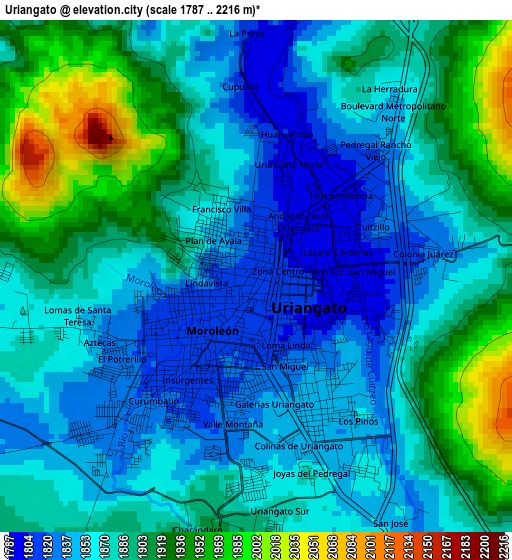
Below is the Elevation map of Uriangato, which displays elevation range with different colors. Scale of the first map is from 1787 to 2216 m (5863 to 7270 ft) with average elevation of 1881.5 meters (=6173 ft) [note 1]
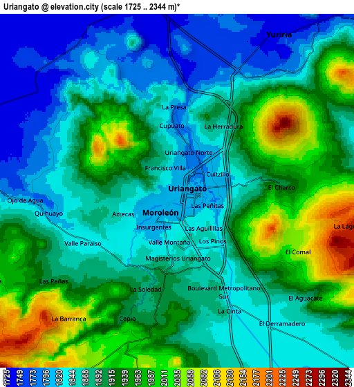
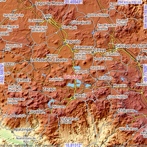
These maps also provides idea of topography and contour of this city, they are displayed at different zoom levels. More info about maps, scale and edge coordinates you can find below images.
| \ | Map #1 | Map #2 | Topo.Map |
| Scale [m] | 1787..2216 m | 1725..2344 m | × |
| Scale [ft] | 5863..7270 ft | 5659..7690 ft | × |
| Average | 1881.5 m = 6173 ft | 1896.2 m = 6221 ft | × |
| Width | 9.17 km = 5.7 mi | 18.35 km = 11.4 mi | 293.6 km = 182.4 mi |
| Height | 9.17 km = 5.7 mi | 18.35 km = 11.4 mi | 293.6 km = 182.4 mi |
| ↑Max Latitude | 20.182103° | 20.223344° | 21.45543° |
| Latitude at center | 20.14085° | 20.14085° | 20.14085° |
| ↓Min Latitude | 20.099587° | 20.058312° | 18.81512° |
| ← Min Longitude | -101.226455° | -101.270401° | -102.58876° |
| Longitude center | -101.18251° | -101.18251° | -101.18251° |
| →Max Longitude | -101.138565° | -101.094619° | -99.77626° |
Nearby cities:
Cities around Uriangato sort by population:
• Moroleón elevation 1815 m
2 km,  210°
210°
• Yuriria 1745 m
9.4 km,  34°
34°
• Parangarico 1775 m
6 km,  17°
17°
• Cuamio 1840 m
12.3 km,  164°
164°
• La Calera 1871 m
16.4 km,  276°
276°
• Cuaracurío 1839 m
9.6 km, 157°
• La Angostura 1747 m
17 km, 26°
• San Andrés Enguaro 1747 m
8.2 km,  316°
316°
• El Moral 1830 m
11.1 km,  263°
263°
• El Canario 1874 m
16.1 km, 276°
• Rinconadas del Bosque 1892 m
6.4 km,  194°
194°
• Piñícuaro 2109 m
12 km, 210°
Multilingual:
 En español:
Uriangato elevación 1810 m.
 En France:
Uriangato élévation 1810 m.
 Auf Deutsch:
Uriangato höhe über dem Meeresspiegel ist 1810 m.

Sources and notes:
- [note 1] Map square and city borders are not equal. Map elevation data is calculated only from area inside that square.
- [src 1] Elevation data from geonames database provided with same terms of usage.
- [src 2] The elevation map of Uriangato is generated using elevation data from NASA's 3 arcsec (90m) resolution SRTM data.
- [src 3] Base (background) map © OpenStreetMap contributors tiles are generated by Geofabrik and OpenTopoMap.
Copyright & License:
This Uriangato Elevation Map is licensed under CC BY-SA. You may reuse any part from this page, if you give a proper credit by linking to this URL:
 More info on terms of use page.