Yuriria elevation
Yuriria (Guanajuato), Mexico elevation is 1745 meters and Yuriria elevation in feet is 5725 ft above sea level [src 1]. Yuriria is a seat of a second-order administrative division (feature code) with elevation that is 431 meters (1414 ft) bigger than average city elevation in Mexico.
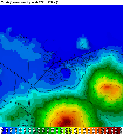
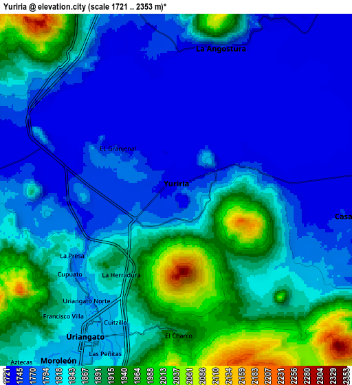
Below is the Elevation map of Yuriria, which displays elevation range with different colors. Scale of the first map is from 1721 to 2337 m (5646 to 7667 ft) with average elevation of 1825.3 meters (=5989 ft) [note 1]
These maps also provides idea of topography and contour of this city, they are displayed at different zoom levels. More info about maps, scale and edge coordinates you can find below images.
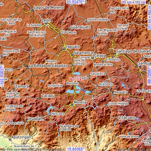
| \ | Map #1 | Map #2 | Topo.Map |
| Scale [m] | 1721..2337 m | 1721..2353 m | × |
| Scale [ft] | 5646..7667 ft | 5646..7720 ft | × |
| Average | 1825.3 m = 5989 ft | 1833.1 m = 6014 ft | × |
| Width | 9.17 km = 5.7 mi | 18.34 km = 11.4 mi | 293.4 km = 182.3 mi |
| Height | 9.17 km = 5.7 mi | 18.34 km = 11.4 mi | 293.5 km = 182.4 mi |
| ↑Max Latitude | 20.252044° | 20.293267° | 21.52478° |
| Latitude at center | 20.21081° | 20.21081° | 20.21081° |
| ↓Min Latitude | 20.169565° | 20.128309° | 18.88565° |
| ← Min Longitude | -101.176065° | -101.220011° | -102.53837° |
| Longitude center | -101.13212° | -101.13212° | -101.13212° |
| →Max Longitude | -101.088175° | -101.044229° | -99.72587° |
Nearby cities:
Cities around Yuriria sort by population:
• Uriangato elevation 1810 m
9.4 km,  214°
214°
• Moroleón 1815 m
11.3 km, 213°
• Santiago Maravatío 1744 m
14.9 km,  106°
106°
• Parangarico 1775 m
4 km,  239°
239°
• Cupareo 1735 m
12.1 km,  80°
80°
• San Jerónimo de Araceo 1883 m
13.7 km,  337°
337°
• Magdalena de Araceo 1849 m
12 km, 336°
• Loma de Zempoala 1741 m
10.5 km,  31°
31°
• La Angostura 1747 m
7.7 km,  17°
17°
• San Andrés Enguaro 1747 m
11 km,  260°
260°
• Puerta del Monte 1733 m
12.3 km,  64°
64°
• Rinconadas del Bosque 1892 m
15.6 km, 206°
Multilingual:
 En español:
Yuriria elevación 1745 m.
 En France:
Yuriria élévation 1745 m.
 Auf Deutsch:
Yuriria höhe über dem Meeresspiegel ist 1745 m.

Sources and notes:
- [note 1] Map square and city borders are not equal. Map elevation data is calculated only from area inside that square.
- [src 1] Elevation data from geonames database provided with same terms of usage.
- [src 2] The elevation map of Yuriria is generated using elevation data from NASA's 3 arcsec (90m) resolution SRTM data.
- [src 3] Base (background) map © OpenStreetMap contributors tiles are generated by Geofabrik and OpenTopoMap.
Copyright & License:
This Yuriria Elevation Map is licensed under CC BY-SA. You may reuse any part from this page, if you give a proper credit by linking to this URL:
 More info on terms of use page.