Magdalena de Araceo elevation
Magdalena de Araceo (Guanajuato, Valle de Santiago), Mexico elevation is 1849 meters and Magdalena de Araceo elevation in feet is 6066 ft above sea level [src 1]. Magdalena de Araceo is a populated place (feature code) with elevation that is 535 meters (1755 ft) bigger than average city elevation in Mexico.
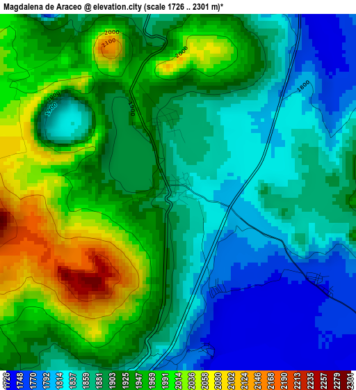
Below is the Elevation map of Magdalena de Araceo, which displays elevation range with different colors. Scale of the first map is from 1726 to 2301 m (5663 to 7549 ft) with average elevation of 1903 meters (=6243 ft) [note 1]
These maps also provides idea of topography and contour of this city, they are displayed at different zoom levels. More info about maps, scale and edge coordinates you can find below images.
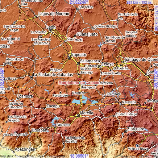
| \ | Map #1 | Topo.Map |
| Scale [m] | 1726..2301 m | × |
| Scale [ft] | 5663..7549 ft | × |
| Average | 1903 m = 6243 ft | × |
| Width | 9.16 km = 5.7 mi | 293.3 km = 182.2 mi |
| Height | 9.17 km = 5.7 mi | 293.3 km = 182.2 mi |
| ↑Max Latitude | 20.350558° | 21.62246° |
| Latitude at center | 20.30935° | 20.30935° |
| ↓Min Latitude | 20.268131° | 18.98501° |
| ← Min Longitude | -101.222555° | -102.58486° |
| Longitude center | -101.17861° | -101.17861° |
| →Max Longitude | -101.134665° | -99.77236° |
Nearby cities:
Cities around Magdalena de Araceo sort by population:
• Valle de Santiago elevation 1752 m
9.2 km,  351°
351°
• Yuriria 1745 m
12 km,  156°
156°
• Parangarico 1775 m
13.1 km,  174°
174°
• San Jerónimo de Araceo 1883 m
1.8 km, 348°
• Loma de Zempoala 1741 m
10.4 km,  100°
100°
• San Nicolás Parangueo 1743 m
12.2 km,  320°
320°
• La Angostura 1747 m
8 km,  116°
116°
• Hacienda de la Bolsa 1748 m
10.7 km,  46°
46°
• Santa Ana 1742 m
9.9 km,  44°
44°
• La Compañía 1728 m
7.9 km,  15°
15°
• Zapotillo de Mogotes 1806 m
10.6 km, 316°
• Hoya de Cintora (La Hoya de Arriba) 1831 m
6.9 km,  333°
333°
Multilingual:
 En español:
La Magdalena de Araceo elevación 1849 m.
 En France:
Magdalena de Araceo élévation 1849 m.
 Auf Deutsch:
Magdalena de Araceo höhe über dem Meeresspiegel ist 1849 m.
 На русском:
Magdalena de Araceo высота над уровнем моря 1849 м
Sources and notes:
- [note 1] Map square and city borders are not equal. Map elevation data is calculated only from area inside that square.
- [src 1] Elevation data from geonames database provided with same terms of usage.
- [src 2] The elevation map of Magdalena de Araceo is generated using elevation data from NASA's 3 arcsec (90m) resolution SRTM data.
- [src 3] Base (background) map © OpenStreetMap contributors tiles are generated by Geofabrik and OpenTopoMap.
Copyright & License:
This Magdalena de Araceo Elevation Map is licensed under CC BY-SA. You may reuse any part from this page, if you give a proper credit by linking to this URL:
 More info on terms of use page.