Valle de Santiago elevation
Valle de Santiago (Guanajuato), Mexico elevation is 1752 meters and Valle de Santiago elevation in feet is 5748 ft above sea level [src 1]. Valle de Santiago is a seat of a second-order administrative division (feature code) with elevation that is 438 meters (1437 ft) bigger than average city elevation in Mexico.
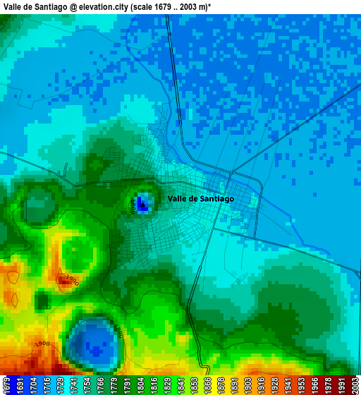
Below is the Elevation map of Valle de Santiago, which displays elevation range with different colors. Scale of the first map is from 1679 to 2003 m (5509 to 6572 ft) with average elevation of 1758.3 meters (=5769 ft) [note 1]
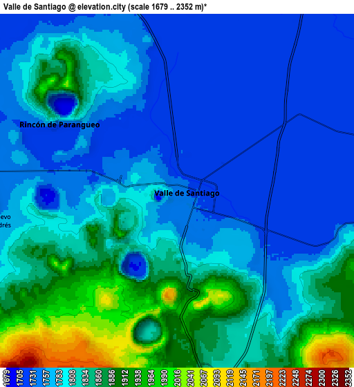
These maps also provides idea of topography and contour of this city, they are displayed at different zoom levels. More info about maps, scale and edge coordinates you can find below images.
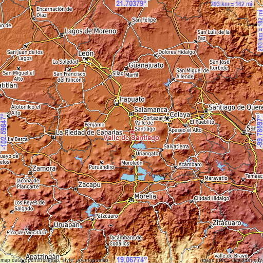
| \ | Map #1 | Map #2 | Topo.Map |
| Scale [m] | 1679..2003 m | 1679..2352 m | × |
| Scale [ft] | 5509..6572 ft | 5509..7717 ft | × |
| Average | 1758.3 m = 5769 ft | 1805.4 m = 5923 ft | × |
| Width | 9.16 km = 5.7 mi | 18.32 km = 11.4 mi | 293.1 km = 182.1 mi |
| Height | 9.16 km = 5.7 mi | 18.32 km = 11.4 mi | 293.1 km = 182.1 mi |
| ↑Max Latitude | 20.432586° | 20.473761° | 21.70379° |
| Latitude at center | 20.3914° | 20.3914° | 20.3914° |
| ↓Min Latitude | 20.350203° | 20.308995° | 19.06774° |
| ← Min Longitude | -101.236165° | -101.280111° | -102.59847° |
| Longitude center | -101.19222° | -101.19222° | -101.19222° |
| →Max Longitude | -101.148275° | -101.104329° | -99.78597° |
Nearby cities:
Cities around Valle de Santiago sort by population:
• Rincón de Parangueo elevation 1725 m
7 km,  298°
298°
• San Jerónimo de Araceo 1883 m
7.5 km,  171°
171°
• Magdalena de Araceo 1849 m
9.2 km, 171°
• San Nicolás Parangueo 1743 m
6.4 km,  272°
272°
• Hacienda de la Bolsa 1748 m
9.3 km,  101°
101°
• San Ignacio de San José Parangueo 1725 m
11.3 km,  283°
283°
• Santa Ana 1742 m
8.6 km, 103°
• La Compañía 1728 m
3.8 km,  113°
113°
• La Tinaja 1723 m
11.3 km,  347°
347°
• Zapotillo de Mogotes 1806 m
6 km,  256°
256°
• Hoya de Cintora (La Hoya de Arriba) 1831 m
3.4 km,  209°
209°
• San Felipe Quiriceo 1721 m
11.7 km, 299°
Multilingual:
 En español:
Valle de Santiago elevación 1752 m.
 En France:
Valle de Santiago élévation 1752 m.
 Auf Deutsch:
Valle de Santiago höhe über dem Meeresspiegel ist 1752 m.
 На русском:
Валье-де-Сантьяго высота над уровнем моря 1752 м
Sources and notes:
- [note 1] Map square and city borders are not equal. Map elevation data is calculated only from area inside that square.
- [src 1] Elevation data from geonames database provided with same terms of usage.
- [src 2] The elevation map of Valle de Santiago is generated using elevation data from NASA's 3 arcsec (90m) resolution SRTM data.
- [src 3] Base (background) map © OpenStreetMap contributors tiles are generated by Geofabrik and OpenTopoMap.
Copyright & License:
This Valle de Santiago Elevation Map is licensed under CC BY-SA. You may reuse any part from this page, if you give a proper credit by linking to this URL:
 More info on terms of use page.