El Canario elevation
El Canario (Guanajuato, Yuriria), Mexico elevation is 1874 meters and El Canario elevation in feet is 6148 ft above sea level [src 1]. El Canario is a populated place (feature code) with elevation that is 560 meters (1837 ft) bigger than average city elevation in Mexico.
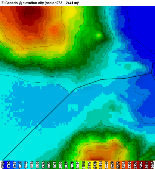
Below is the Elevation map of El Canario, which displays elevation range with different colors. Scale of the first map is from 1733 to 2441 m (5686 to 8009 ft) with average elevation of 1941.4 meters (=6369 ft) [note 1]
These maps also provides idea of topography and contour of this city, they are displayed at different zoom levels. More info about maps, scale and edge coordinates you can find below images.
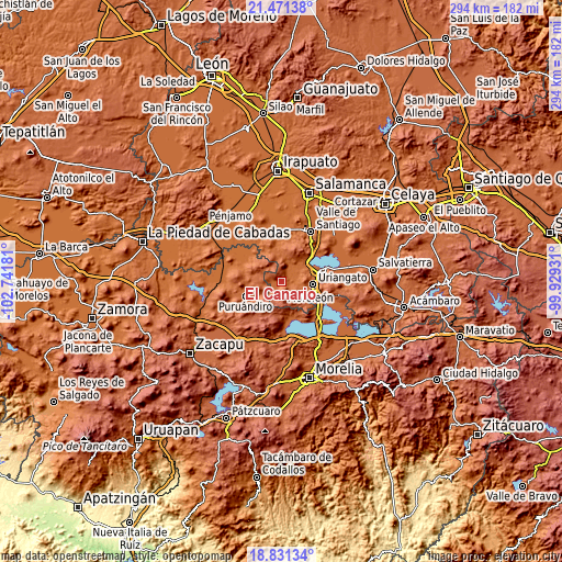
| \ | Map #1 | Topo.Map |
| Scale [m] | 1733..2441 m | × |
| Scale [ft] | 5686..8009 ft | × |
| Average | 1941.4 m = 6369 ft | × |
| Width | 9.17 km = 5.7 mi | 293.5 km = 182.4 mi |
| Height | 9.17 km = 5.7 mi | 293.6 km = 182.4 mi |
| ↑Max Latitude | 20.198188° | 21.47138° |
| Latitude at center | 20.15694° | 20.15694° |
| ↓Min Latitude | 20.115681° | 18.83134° |
| ← Min Longitude | -101.379505° | -102.74181° |
| Longitude center | -101.33556° | -101.33556° |
| →Max Longitude | -101.291615° | -99.92931° |
Nearby cities:
Cities around El Canario sort by population:
• Moroleón elevation 1815 m
15.4 km,  103°
103°
• Cerano 1882 m
7.6 km,  225°
225°
• Santa Clara 1998 m
10.5 km,  283°
283°
• La Calera 1871 m
0.3 km, 281°
• Jícamas 1860 m
13.5 km,  349°
349°
• Tejocote de Calera 1985 m
6.9 km,  291°
291°
• San Andrés Enguaro 1747 m
11.2 km,  67°
67°
• El Moral 1830 m
5.7 km,  121°
121°
• Las Letras 2132 m
13.1 km,  308°
308°
• El Pilar 2269 m
11.7 km,  323°
323°
• Las Ranas 2088 m
15.9 km, 291°
• Piñícuaro 2109 m
15.7 km,  140°
140°
Multilingual:
 En español:
El Canario elevación 1874 m.
 En France:
El Canario élévation 1874 m.
 Auf Deutsch:
El Canario höhe über dem Meeresspiegel ist 1874 m.

Sources and notes:
- [note 1] Map square and city borders are not equal. Map elevation data is calculated only from area inside that square.
- [src 1] Elevation data from geonames database provided with same terms of usage.
- [src 2] The elevation map of El Canario is generated using elevation data from NASA's 3 arcsec (90m) resolution SRTM data.
- [src 3] Base (background) map © OpenStreetMap contributors tiles are generated by Geofabrik and OpenTopoMap.
Copyright & License:
This El Canario Elevation Map is licensed under CC BY-SA. You may reuse any part from this page, if you give a proper credit by linking to this URL:
 More info on terms of use page.