El Barril elevation
El Barril (San Luis Potosí, Villa de Ramos), Mexico elevation is 1969 meters and El Barril elevation in feet is 6460 ft above sea level [src 1]. El Barril is a populated place (feature code) with elevation that is 655 meters (2149 ft) bigger than average city elevation in Mexico.
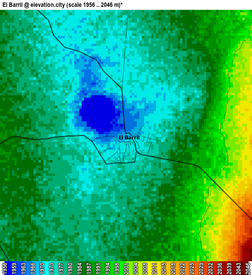
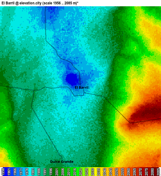
Below is the Elevation map of El Barril, which displays elevation range with different colors. Scale of the first map is from 1956 to 2046 m (6417 to 6713 ft) with average elevation of 1983.3 meters (=6507 ft) [note 1]
These maps also provides idea of topography and contour of this city, they are displayed at different zoom levels. More info about maps, scale and edge coordinates you can find below images.
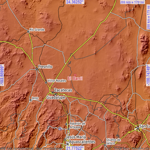
| \ | Map #1 | Map #2 | Topo.Map |
| Scale [m] | 1956..2046 m | 1956..2085 m | × |
| Scale [ft] | 6417..6713 ft | 6417..6841 ft | × |
| Average | 1983.3 m = 6507 ft | 1999.4 m = 6560 ft | × |
| Width | 8.99 km = 5.6 mi | 17.98 km = 11.2 mi | 287.7 km = 178.8 mi |
| Height | 8.99 km = 5.6 mi | 17.98 km = 11.2 mi | 287.7 km = 178.8 mi |
| ↑Max Latitude | 23.115513° | 23.155924° | 24.36252° |
| Latitude at center | 23.07509° | 23.07509° | 23.07509° |
| ↓Min Latitude | 23.034655° | 22.994207° | 21.77522° |
| ← Min Longitude | -102.197685° | -102.241631° | -103.55999° |
| Longitude center | -102.15374° | -102.15374° | -102.15374° |
| →Max Longitude | -102.109795° | -102.065849° | -100.74749° |
Nearby cities:
Cities around El Barril sort by population:
• Dulce Grande elevation 1988 m
8.4 km,  194°
194°
• Los Zacatones 2051 m
16.1 km,  141°
141°
• Villa de Cos 1982 m
31.5 km,  320°
320°
• Chaparrosa 1987 m
12.7 km,  274°
274°
• Salitral de Carrera 2039 m
24.3 km,  162°
162°
• Chupaderos 1973 m
19.9 km,  297°
297°
• Hernández 2035 m
12.8 km,  111°
111°
• Jesús María 1965 m
9.7 km,  335°
335°
• Illescas 1942 m
18.4 km,  2°
2°
• Santa Rita 2084 m
32.6 km,  236°
236°
• La Luz 2049 m
27 km,  216°
216°
• Sauz de Calera 2074 m
23.4 km, 188°
Multilingual:
 En español:
El Barril elevación 1969 m.
 En France:
El Barril élévation 1969 m.
 Auf Deutsch:
El Barril höhe über dem Meeresspiegel ist 1969 m.

Sources and notes:
- [note 1] Map square and city borders are not equal. Map elevation data is calculated only from area inside that square.
- [src 1] Elevation data from geonames database provided with same terms of usage.
- [src 2] The elevation map of El Barril is generated using elevation data from NASA's 3 arcsec (90m) resolution SRTM data.
- [src 3] Base (background) map © OpenStreetMap contributors tiles are generated by Geofabrik and OpenTopoMap.
Copyright & License:
This El Barril Elevation Map is licensed under CC BY-SA. You may reuse any part from this page, if you give a proper credit by linking to this URL:
 More info on terms of use page.