La Luz elevation
La Luz (Zacatecas, Guadalupe), Mexico elevation is 2049 meters and La Luz elevation in feet is 6722 ft above sea level [src 1]. La Luz is a populated place (feature code) with elevation that is 735 meters (2411 ft) bigger than average city elevation in Mexico.
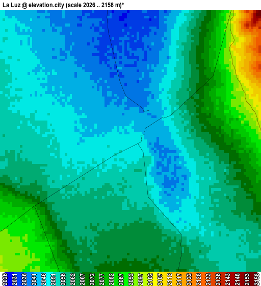
Below is the Elevation map of La Luz, which displays elevation range with different colors. Scale of the first map is from 2026 to 2158 m (6647 to 7080 ft) with average elevation of 2058.9 meters (=6755 ft) [note 1]
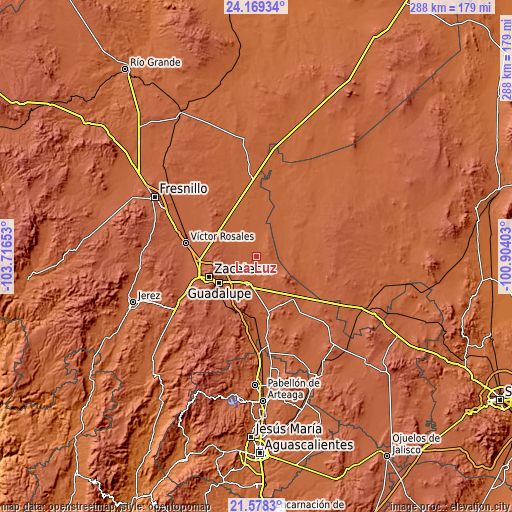
These maps also provides idea of topography and contour of this city, they are displayed at different zoom levels. More info about maps, scale and edge coordinates you can find below images.
| \ | Map #1 | Topo.Map |
| Scale [m] | 2026..2158 m | × |
| Scale [ft] | 6647..7080 ft | × |
| Average | 2058.9 m = 6755 ft | × |
| Width | 9 km = 5.6 mi | 288.1 km = 179 mi |
| Height | 9 km = 5.6 mi | 288.1 km = 179 mi |
| ↑Max Latitude | 22.920482° | 24.16934° |
| Latitude at center | 22.88° | 22.88° |
| ↓Min Latitude | 22.839506° | 21.5783° |
| ← Min Longitude | -102.354225° | -103.71653° |
| Longitude center | -102.31028° | -102.31028° |
| →Max Longitude | -102.266335° | -100.90403° |
Nearby cities:
Cities around La Luz sort by population:
• Trancoso elevation 2190 m
17.1 km,  199°
199°
• Tacoaleche 2141 m
11.8 km,  235°
235°
• Dulce Grande 1988 m
19.4 km,  45°
45°
• Zoquite 2170 m
15.6 km,  227°
227°
• San Antonio del Cipres 2166 m
19.2 km,  289°
289°
• Sauceda de La Borda 2298 m
20.5 km,  254°
254°
• El Lampotal 2089 m
11.3 km,  278°
278°
• Santa Rita 2084 m
11.6 km, 287°
• San José de la Era 2126 m
11.9 km, 254°
• Sauz de Calera 2074 m
12.7 km,  96°
96°
• Casa de Cerros 2253 m
21.6 km,  271°
271°
• Santa Mónica 2193 m
18 km,  219°
219°
Multilingual:
 En español:
La Luz elevación 2049 m.
 En France:
La Luz élévation 2049 m.


Sources and notes:
- [note 1] Map square and city borders are not equal. Map elevation data is calculated only from area inside that square.
- [src 1] Elevation data from geonames database provided with same terms of usage.
- [src 2] The elevation map of La Luz is generated using elevation data from NASA's 3 arcsec (90m) resolution SRTM data.
- [src 3] Base (background) map © OpenStreetMap contributors tiles are generated by Geofabrik and OpenTopoMap.
Copyright & License:
This La Luz Elevation Map is licensed under CC BY-SA. You may reuse any part from this page, if you give a proper credit by linking to this URL:
 More info on terms of use page.