Tacoaleche elevation
Tacoaleche (Zacatecas, Guadalupe), Mexico elevation is 2141 meters and Tacoaleche elevation in feet is 7024 ft above sea level [src 1]. Tacoaleche is a populated place (feature code) with elevation that is 827 meters (2713 ft) bigger than average city elevation in Mexico.
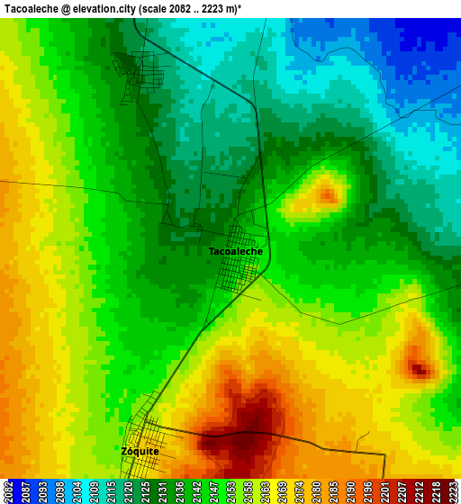
Below is the Elevation map of Tacoaleche, which displays elevation range with different colors. Scale of the first map is from 2082 to 2223 m (6831 to 7293 ft) with average elevation of 2146.4 meters (=7042 ft) [note 1]
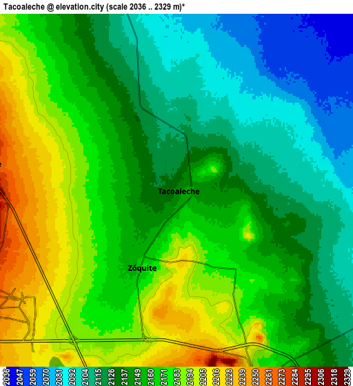
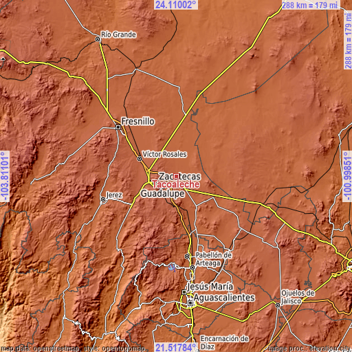
These maps also provides idea of topography and contour of this city, they are displayed at different zoom levels. More info about maps, scale and edge coordinates you can find below images.
| \ | Map #1 | Map #2 | Topo.Map |
| Scale [m] | 2082..2223 m | 2036..2329 m | × |
| Scale [ft] | 6831..7293 ft | 6680..7641 ft | × |
| Average | 2146.4 m = 7042 ft | 2151.4 m = 7058 ft | × |
| Width | 9.01 km = 5.6 mi | 18.02 km = 11.2 mi | 288.2 km = 179.1 mi |
| Height | 9.01 km = 5.6 mi | 18.02 km = 11.2 mi | 288.2 km = 179.1 mi |
| ↑Max Latitude | 22.8606° | 22.901087° | 24.11002° |
| Latitude at center | 22.8201° | 22.8201° | 22.8201° |
| ↓Min Latitude | 22.779588° | 22.739065° | 21.51784° |
| ← Min Longitude | -102.448705° | -102.492651° | -103.81101° |
| Longitude center | -102.40476° | -102.40476° | -102.40476° |
| →Max Longitude | -102.360815° | -102.316869° | -100.99851° |
Nearby cities:
Cities around Tacoaleche sort by population:
• Guadalupe elevation 2280 m
14.2 km,  235°
235°
• Trancoso 2190 m
10.2 km,  157°
157°
• Zoquite 2170 m
4.3 km,  205°
205°
• La Zacatecana 2216 m
12.3 km,  215°
215°
• Sauceda de La Borda 2298 m
10.1 km,  276°
276°
• Martínez Domínguez 2222 m
11.2 km, 224°
• El Lampotal 2089 m
8.6 km,  349°
349°
• Santa Rita 2084 m
10.3 km, 352°
• San José de la Era 2126 m
3.9 km,  332°
332°
• La Luz 2049 m
11.8 km,  55°
55°
• Casa de Cerros 2253 m
13.9 km,  301°
301°
• Santa Mónica 2193 m
7.5 km,  193°
193°
Multilingual:
 En español:
Tacoaleche elevación 2141 m.
 En France:
Tacoaleche élévation 2141 m.
 Auf Deutsch:
Tacoaleche höhe über dem Meeresspiegel ist 2141 m.

Sources and notes:
- [note 1] Map square and city borders are not equal. Map elevation data is calculated only from area inside that square.
- [src 1] Elevation data from geonames database provided with same terms of usage.
- [src 2] The elevation map of Tacoaleche is generated using elevation data from NASA's 3 arcsec (90m) resolution SRTM data.
- [src 3] Base (background) map © OpenStreetMap contributors tiles are generated by Geofabrik and OpenTopoMap.
Copyright & License:
This Tacoaleche Elevation Map is licensed under CC BY-SA. You may reuse any part from this page, if you give a proper credit by linking to this URL:
 More info on terms of use page.