Guadalupe elevation
Guadalupe (Zacatecas), Mexico elevation is 2280 meters and Guadalupe elevation in feet is 7480 ft above sea level [src 1]. Guadalupe is a seat of a second-order administrative division (feature code) with elevation that is 966 meters (3169 ft) bigger than average city elevation in Mexico.
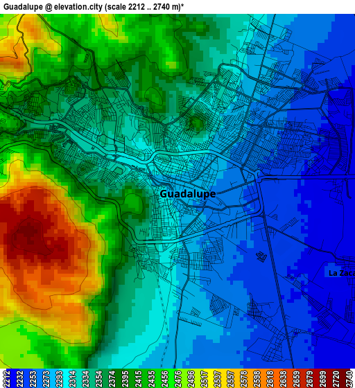
Below is the Elevation map of Guadalupe, which displays elevation range with different colors. Scale of the first map is from 2212 to 2740 m (7257 to 8990 ft) with average elevation of 2351.1 meters (=7714 ft) [note 1]
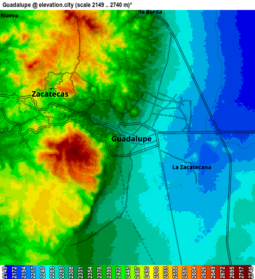
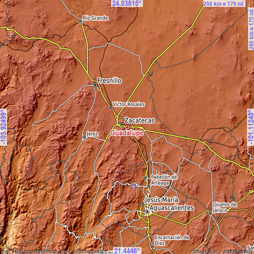
These maps also provides idea of topography and contour of this city, they are displayed at different zoom levels. More info about maps, scale and edge coordinates you can find below images.
| \ | Map #1 | Map #2 | Topo.Map |
| Scale [m] | 2212..2740 m | 2149..2740 m | × |
| Scale [ft] | 7257..8990 ft | 7051..8990 ft | × |
| Average | 2351.1 m = 7714 ft | 2348.8 m = 7706 ft | × |
| Width | 9.01 km = 5.6 mi | 18.02 km = 11.2 mi | 288.4 km = 179.2 mi |
| Height | 9.01 km = 5.6 mi | 18.02 km = 11.2 mi | 288.4 km = 179.2 mi |
| ↑Max Latitude | 22.788051° | 22.82856° | 24.03815° |
| Latitude at center | 22.74753° | 22.74753° | 22.74753° |
| ↓Min Latitude | 22.706997° | 22.666452° | 21.4446° |
| ← Min Longitude | -102.562685° | -102.606631° | -103.92499° |
| Longitude center | -102.51874° | -102.51874° | -102.51874° |
| →Max Longitude | -102.474795° | -102.430849° | -101.11249° |
Nearby cities:
Cities around Guadalupe sort by population:
• Zacatecas elevation 2480 m
6.8 km,  289°
289°
• Tacoaleche 2141 m
14.2 km,  55°
55°
• Zoquite 2170 m
10.7 km,  66°
66°
• Hacienda Nueva 2348 m
12.6 km,  313°
313°
• La Zacatecana 2216 m
4.9 km,  112°
112°
• Sauceda de La Borda 2298 m
9.4 km,  10°
10°
• San Jerónimo 2271 m
10.8 km,  165°
165°
• Cieneguitas 2240 m
4.6 km,  145°
145°
• Martínez Domínguez 2222 m
3.9 km,  89°
89°
• Las Pilas 2338 m
14.1 km,  316°
316°
• Vetagrande 2544 m
10.4 km,  338°
338°
• Santa Mónica 2193 m
9.9 km, 85°
Multilingual:
 En español:
Guadalupe elevación 2280 m.
 En France:
Guadalupe élévation 2280 m.
 Auf Deutsch:
Guadalupe höhe über dem Meeresspiegel ist 2280 m.

Sources and notes:
- [note 1] Map square and city borders are not equal. Map elevation data is calculated only from area inside that square.
- [src 1] Elevation data from geonames database provided with same terms of usage.
- [src 2] The elevation map of Guadalupe is generated using elevation data from NASA's 3 arcsec (90m) resolution SRTM data.
- [src 3] Base (background) map © OpenStreetMap contributors tiles are generated by Geofabrik and OpenTopoMap.
Copyright & License:
This Guadalupe Elevation Map is licensed under CC BY-SA. You may reuse any part from this page, if you give a proper credit by linking to this URL:
 More info on terms of use page.