Villa de Cos elevation
Villa de Cos (Zacatecas), Mexico elevation is 1982 meters and Villa de Cos elevation in feet is 6503 ft above sea level [src 1]. Villa de Cos is a seat of a second-order administrative division (feature code) with elevation that is 668 meters (2192 ft) bigger than average city elevation in Mexico.
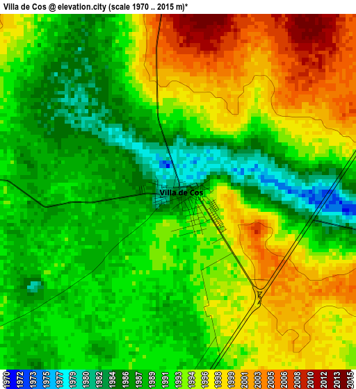
Below is the Elevation map of Villa de Cos, which displays elevation range with different colors. Scale of the first map is from 1970 to 2015 m (6463 to 6611 ft) with average elevation of 1992.6 meters (=6537 ft) [note 1]
These maps also provides idea of topography and contour of this city, they are displayed at different zoom levels. More info about maps, scale and edge coordinates you can find below images.
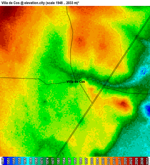
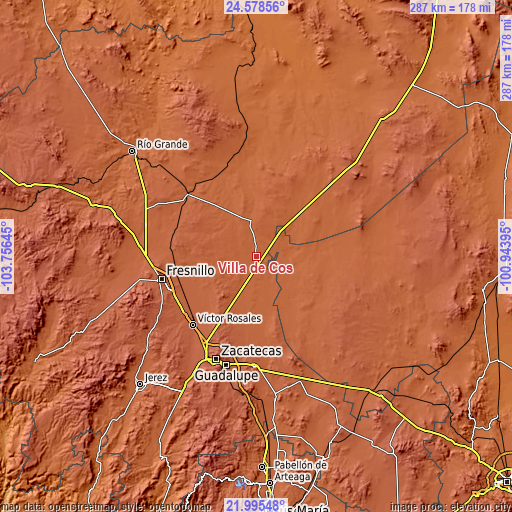
| \ | Map #1 | Map #2 | Topo.Map |
| Scale [m] | 1970..2015 m | 1948..2033 m | × |
| Scale [ft] | 6463..6611 ft | 6391..6670 ft | × |
| Average | 1992.6 m = 6537 ft | 1994.3 m = 6543 ft | × |
| Width | 8.98 km = 5.6 mi | 17.95 km = 11.2 mi | 287.2 km = 178.5 mi |
| Height | 8.98 km = 5.6 mi | 17.95 km = 11.2 mi | 287.2 km = 178.5 mi |
| ↑Max Latitude | 23.333647° | 23.373992° | 24.57856° |
| Latitude at center | 23.29329° | 23.29329° | 23.29329° |
| ↓Min Latitude | 23.25292° | 23.212539° | 21.99548° |
| ← Min Longitude | -102.394145° | -102.438091° | -103.75645° |
| Longitude center | -102.3502° | -102.3502° | -102.3502° |
| →Max Longitude | -102.306255° | -102.262309° | -100.94395° |
Nearby cities:
Cities around Villa de Cos sort by population:
• El Barril elevation 1969 m
31.5 km,  140°
140°
• Gonzales Ortega 2042 m
17.9 km,  225°
225°
• Chaparrosa 1987 m
24.5 km,  162°
162°
• Chupaderos 1973 m
15.2 km,  170°
170°
• Rafael Yáñez Sosa (El Mezquite) 2093 m
26.8 km,  278°
278°
• Jesús María 1965 m
22.3 km,  133°
133°
• Illescas 1942 m
21.8 km,  105°
105°
• Las Catarinas 2093 m
35.3 km, 230°
• Chichimequillas 2069 m
24.1 km,  255°
255°
• Santiaguillo 2079 m
34.9 km,  242°
242°
• El Rucio 1992 m
30.2 km,  65°
65°
• Laguna Seca 2082 m
29.7 km,  209°
209°
Multilingual:
 En español:
Villa de Cos elevación 1982 m.
 En France:
Villa de Cos élévation 1982 m.
 Auf Deutsch:
Villa de Cos höhe über dem Meeresspiegel ist 1982 m.

Sources and notes:
- [note 1] Map square and city borders are not equal. Map elevation data is calculated only from area inside that square.
- [src 1] Elevation data from geonames database provided with same terms of usage.
- [src 2] The elevation map of Villa de Cos is generated using elevation data from NASA's 3 arcsec (90m) resolution SRTM data.
- [src 3] Base (background) map © OpenStreetMap contributors tiles are generated by Geofabrik and OpenTopoMap.
Copyright & License:
This Villa de Cos Elevation Map is licensed under CC BY-SA. You may reuse any part from this page, if you give a proper credit by linking to this URL:
 More info on terms of use page.