Monte Verde elevation
Monte Verde (Chihuahua, Janos), Mexico elevation is 1415 meters and Monte Verde elevation in feet is 4642 ft above sea level [src 1]. Monte Verde is a populated place (feature code) with elevation that is 101 meters (331 ft) bigger than average city elevation in Mexico.
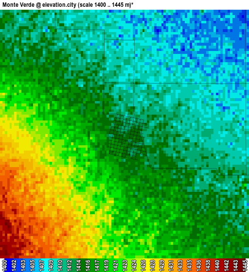
Below is the Elevation map of Monte Verde, which displays elevation range with different colors. Scale of the first map is from 1400 to 1445 m (4593 to 4741 ft) with average elevation of 1416.3 meters (=4647 ft) [note 1]
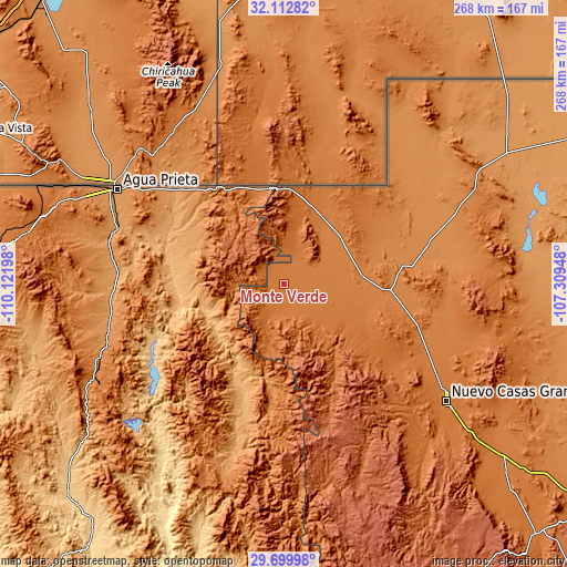
These maps also provides idea of topography and contour of this city, they are displayed at different zoom levels. More info about maps, scale and edge coordinates you can find below images.
| \ | Map #1 | Topo.Map |
| Scale [m] | 1400..1445 m | × |
| Scale [ft] | 4593..4741 ft | × |
| Average | 1416.3 m = 4647 ft | × |
| Width | 8.38 km = 5.2 mi | 268.3 km = 166.7 mi |
| Height | 8.38 km = 5.2 mi | 268.3 km = 166.7 mi |
| ↑Max Latitude | 30.951705° | 32.11282° |
| Latitude at center | 30.91401° | 30.91401° |
| ↓Min Latitude | 30.8763° | 29.69998° |
| ← Min Longitude | -108.759675° | -110.12198° |
| Longitude center | -108.71573° | -108.71573° |
| →Max Longitude | -108.671785° | -107.30948° |
Nearby cities:
Cities around Monte Verde sort by population:
• Agua Prieta elevation 1219 m
91.8 km,  300°
300°
• Nuevo Casas Grandes 1455 m
94.8 km,  125°
125°
• Ascensión 1299 m
71.3 km,  73°
73°
• Ascención 1297 m
72.8 km, 73°
• Esqueda 1204 m
86 km,  255°
255°
• Casas Grandes 1476 m
93.6 km, 129°
• Janos 1361 m
49.8 km,  93°
93°
• Bacerac 1040 m
65.4 km,  198°
198°
• Juárez 1536 m
90.7 km,  137°
137°
• Huachinera 1126 m
81.6 km, 196°
• Fronteras 1135 m
80.5 km,  268°
268°
• Bavispe 1016 m
52.9 km, 203°
Multilingual:
 En español:
Monte Verde elevación 1415 m.
 En France:
Monte Verde élévation 1415 m.
 Auf Deutsch:
Monte Verde höhe über dem Meeresspiegel ist 1415 m.

Sources and notes:
- [note 1] Map square and city borders are not equal. Map elevation data is calculated only from area inside that square.
- [src 1] Elevation data from geonames database provided with same terms of usage.
- [src 2] The elevation map of Monte Verde is generated using elevation data from NASA's 3 arcsec (90m) resolution SRTM data.
- [src 3] Base (background) map © OpenStreetMap contributors tiles are generated by Geofabrik and OpenTopoMap.
Copyright & License:
This Monte Verde Elevation Map is licensed under CC BY-SA. You may reuse any part from this page, if you give a proper credit by linking to this URL:
 More info on terms of use page.