Janos elevation
Janos (Chihuahua), Mexico elevation is 1361 meters and Janos elevation in feet is 4465 ft above sea level [src 1]. Janos is a seat of a second-order administrative division (feature code) with elevation that is 47 meters (154 ft) bigger than average city elevation in Mexico.
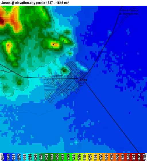
Below is the Elevation map of Janos, which displays elevation range with different colors. Scale of the first map is from 1337 to 1646 m (4386 to 5400 ft) with average elevation of 1377 meters (=4518 ft) [note 1]
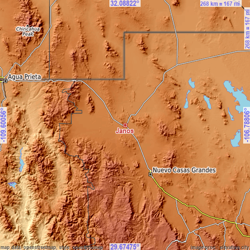
These maps also provides idea of topography and contour of this city, they are displayed at different zoom levels. More info about maps, scale and edge coordinates you can find below images.
| \ | Map #1 | Topo.Map |
| Scale [m] | 1337..1646 m | × |
| Scale [ft] | 4386..5400 ft | × |
| Average | 1377 m = 4518 ft | × |
| Width | 8.39 km = 5.2 mi | 268.4 km = 166.8 mi |
| Height | 8.39 km = 5.2 mi | 268.4 km = 166.8 mi |
| ↑Max Latitude | 30.926795° | 32.08822° |
| Latitude at center | 30.88909° | 30.88909° |
| ↓Min Latitude | 30.85137° | 29.67475° |
| ← Min Longitude | -108.238255° | -109.60056° |
| Longitude center | -108.19431° | -108.19431° |
| →Max Longitude | -108.150365° | -106.78806° |
Nearby cities:
Cities around Janos sort by population:
• Nuevo Casas Grandes elevation 1455 m
59.2 km,  152°
152°
• Ascensión 1299 m
29.4 km,  39°
39°
• Ascención 1297 m
30.9 km, 40°
• Puerto Palomas 1221 m
112.2 km,  28°
28°
• Casas Grandes 1476 m
60.7 km,  157°
157°
• Guadalupe Victoria 1230 m
83.8 km, 31°
• Bacerac 1040 m
92.2 km,  229°
229°
• Monte Verde 1415 m
49.8 km,  273°
273°
• Juárez 1536 m
65.4 km,  170°
170°
• Huachinera 1126 m
105.1 km,  224°
224°
• Bavispe 1016 m
84.6 km,  237°
237°
• Galeana 1430 m
102.4 km, 147°
Multilingual:
 En español:
Janos elevación 1361 m.
 En France:
Janos élévation 1361 m.


Sources and notes:
- [note 1] Map square and city borders are not equal. Map elevation data is calculated only from area inside that square.
- [src 1] Elevation data from geonames database provided with same terms of usage.
- [src 2] The elevation map of Janos is generated using elevation data from NASA's 3 arcsec (90m) resolution SRTM data.
- [src 3] Base (background) map © OpenStreetMap contributors tiles are generated by Geofabrik and OpenTopoMap.
Copyright & License:
This Janos Elevation Map is licensed under CC BY-SA. You may reuse any part from this page, if you give a proper credit by linking to this URL:
 More info on terms of use page.