Bavispe elevation
Bavispe (Sonora), Mexico elevation is 1016 meters and Bavispe elevation in feet is 3333 ft above sea level [src 1]. Bavispe is a seat of a second-order administrative division (feature code) with elevation that is 298 meters (978 ft) smaller than average city elevation in Mexico.
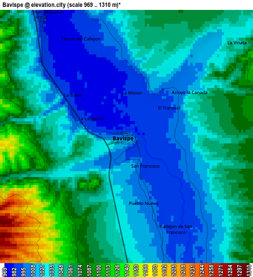
Below is the Elevation map of Bavispe, which displays elevation range with different colors. Scale of the first map is from 969 to 1310 m (3179 to 4298 ft) with average elevation of 1042.7 meters (=3421 ft) [note 1]
These maps also provides idea of topography and contour of this city, they are displayed at different zoom levels. More info about maps, scale and edge coordinates you can find below images.
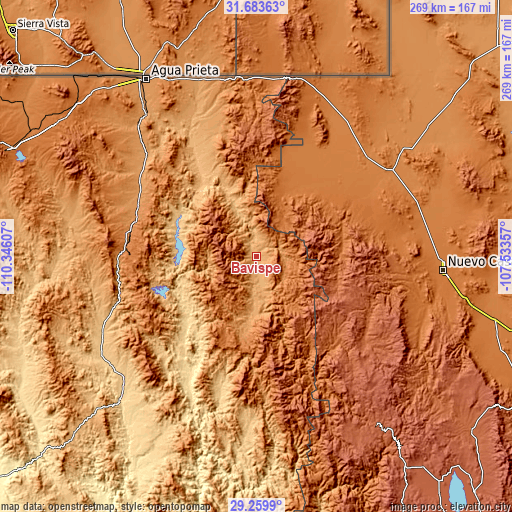
| \ | Map #1 | Topo.Map |
| Scale [m] | 969..1310 m | × |
| Scale [ft] | 3179..4298 ft | × |
| Average | 1042.7 m = 3421 ft | × |
| Width | 8.42 km = 5.2 mi | 269.5 km = 167.5 mi |
| Height | 8.42 km = 5.2 mi | 269.5 km = 167.5 mi |
| ↑Max Latitude | 30.517175° | 31.68363° |
| Latitude at center | 30.47931° | 30.47931° |
| ↓Min Latitude | 30.44143° | 29.2599° |
| ← Min Longitude | -108.983765° | -110.34607° |
| Longitude center | -108.93982° | -108.93982° |
| →Max Longitude | -108.895875° | -107.53357° |
Nearby cities:
Cities around Bavispe sort by population:
• Nacozari Viejo elevation 1352 m
68.6 km,  262°
262°
• Nacozari de García 1106 m
72.8 km, 260°
• Esqueda 1204 m
67.9 km,  293°
293°
• Janos 1361 m
84.6 km,  57°
57°
• Villa Hidalgo 637 m
50.9 km,  226°
226°
• Bacadéhuachi 702 m
77 km,  194°
194°
• Granados 537 m
77.3 km,  207°
207°
• Bacerac 1040 m
13.8 km,  176°
176°
• Monte Verde 1415 m
52.9 km,  23°
23°
• Huachinera 1126 m
30 km, 183°
• Huásabas 545 m
72.4 km, 208°
• Fronteras 1135 m
75.3 km,  308°
308°
Multilingual:
 En español:
Bavispe elevación 1016 m.
 En France:
Bavispe élévation 1016 m.
 Auf Deutsch:
Bavispe höhe über dem Meeresspiegel ist 1016 m.

Sources and notes:
- [note 1] Map square and city borders are not equal. Map elevation data is calculated only from area inside that square.
- [src 1] Elevation data from geonames database provided with same terms of usage.
- [src 2] The elevation map of Bavispe is generated using elevation data from NASA's 3 arcsec (90m) resolution SRTM data.
- [src 3] Base (background) map © OpenStreetMap contributors tiles are generated by Geofabrik and OpenTopoMap.
Copyright & License:
This Bavispe Elevation Map is licensed under CC BY-SA. You may reuse any part from this page, if you give a proper credit by linking to this URL:
 More info on terms of use page.