Allende elevation
Allende (Jalisco, Jesús María), Mexico elevation is 2264 meters and Allende elevation in feet is 7428 ft above sea level [src 1]. Allende is a populated place (feature code) with elevation that is 950 meters (3117 ft) bigger than average city elevation in Mexico.
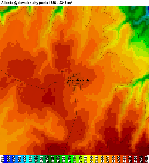
Below is the Elevation map of Allende, which displays elevation range with different colors. Scale of the first map is from 1888 to 2343 m (6194 to 7687 ft) with average elevation of 2234.8 meters (=7332 ft) [note 1]
These maps also provides idea of topography and contour of this city, they are displayed at different zoom levels. More info about maps, scale and edge coordinates you can find below images.
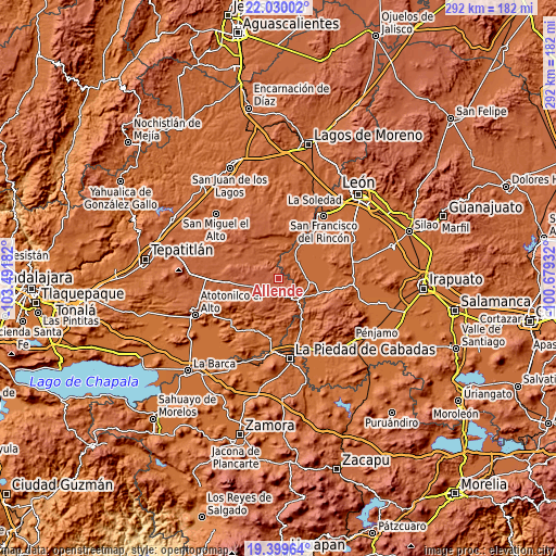
| \ | Map #1 | Topo.Map |
| Scale [m] | 1888..2343 m | × |
| Scale [ft] | 6194..7687 ft | × |
| Average | 2234.8 m = 7332 ft | × |
| Width | 9.14 km = 5.7 mi | 292.5 km = 181.8 mi |
| Height | 9.14 km = 5.7 mi | 292.5 km = 181.8 mi |
| ↑Max Latitude | 20.761637° | 22.03002° |
| Latitude at center | 20.72054° | 20.72054° |
| ↓Min Latitude | 20.679432° | 19.39964° |
| ← Min Longitude | -102.129515° | -103.49182° |
| Longitude center | -102.08557° | -102.08557° |
| →Max Longitude | -102.041625° | -100.67932° |
Nearby cities:
Cities around Allende sort by population:
• Arandas elevation 2069 m
27.2 km,  266°
266°
• Ciudad Manuel Doblado 1728 m
13.9 km,  86°
86°
• Degollado 1793 m
29 km,  193°
193°
• Jesús María 2097 m
19.1 km,  228°
228°
• San Ángel 1755 m
26.6 km,  40°
40°
• El Tecolote 1738 m
24.7 km, 42°
• Cañada de Negros 1807 m
28.6 km, 36°
• Peñuelas 1755 m
30 km,  53°
53°
• Frías 1754 m
12.8 km, 46°
• Calzada del Tepozán 1722 m
21.2 km,  84°
84°
• Santiaguito (Santiaguito de Velázquez) 2189 m
15.8 km, 271°
• San José de la Paz 1918 m
19.1 km,  171°
171°
Multilingual:
 En español:
Allende elevación 2264 m.
 En France:
Allende élévation 2264 m.
 Auf Deutsch:
Allende höhe über dem Meeresspiegel ist 2264 m.

Sources and notes:
- [note 1] Map square and city borders are not equal. Map elevation data is calculated only from area inside that square.
- [src 1] Elevation data from geonames database provided with same terms of usage.
- [src 2] The elevation map of Allende is generated using elevation data from NASA's 3 arcsec (90m) resolution SRTM data.
- [src 3] Base (background) map © OpenStreetMap contributors tiles are generated by Geofabrik and OpenTopoMap.
Copyright & License:
This Allende Elevation Map is licensed under CC BY-SA. You may reuse any part from this page, if you give a proper credit by linking to this URL:
 More info on terms of use page.