Cañada de Negros elevation
Cañada de Negros (Guanajuato, Purísima del Rincón), Mexico elevation is 1807 meters and Cañada de Negros elevation in feet is 5928 ft above sea level [src 1]. Cañada de Negros is a populated place (feature code) with elevation that is 493 meters (1617 ft) bigger than average city elevation in Mexico.
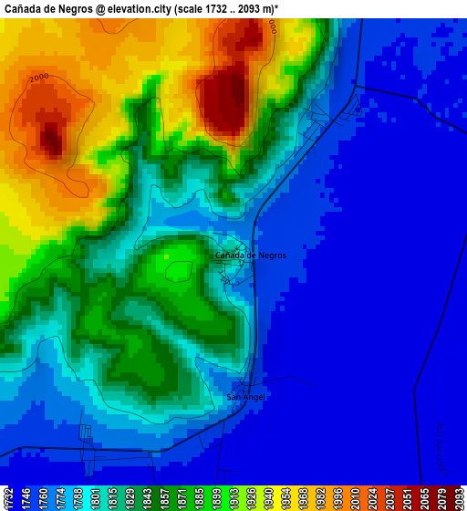
Below is the Elevation map of Cañada de Negros, which displays elevation range with different colors. Scale of the first map is from 1732 to 2093 m (5682 to 6867 ft) with average elevation of 1820.3 meters (=5972 ft) [note 1]
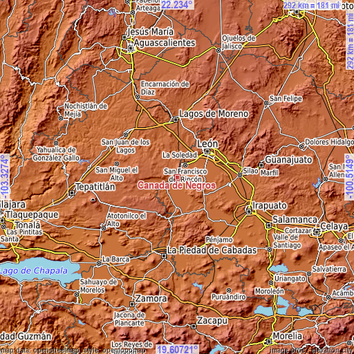
These maps also provides idea of topography and contour of this city, they are displayed at different zoom levels. More info about maps, scale and edge coordinates you can find below images.
| \ | Map #1 | Topo.Map |
| Scale [m] | 1732..2093 m | × |
| Scale [ft] | 5682..6867 ft | × |
| Average | 1820.3 m = 5972 ft | × |
| Width | 9.13 km = 5.7 mi | 292.1 km = 181.5 mi |
| Height | 9.13 km = 5.7 mi | 292.1 km = 181.5 mi |
| ↑Max Latitude | 20.967401° | 22.234° |
| Latitude at center | 20.92636° | 20.92636° |
| ↓Min Latitude | 20.885308° | 19.60721° |
| ← Min Longitude | -101.965095° | -103.3274° |
| Longitude center | -101.92115° | -101.92115° |
| →Max Longitude | -101.877205° | -100.5149° |
Nearby cities:
Cities around Cañada de Negros sort by population:
• San Francisco del Rincón elevation 1757 m
12.3 km,  33°
33°
• San Diego de Alejandría 1947 m
10.8 km,  314°
314°
• El Maguey 1756 m
9.8 km,  52°
52°
• San Ignacio de Hidalgo 1743 m
6.5 km,  104°
104°
• Monte Grande 1751 m
10 km,  36°
36°
• San Ángel 1755 m
2.7 km,  175°
175°
• San Bernardo 1748 m
7 km, 49°
• El Tecolote 1738 m
4.7 km, 184°
• San Roque de Torres 1751 m
8.7 km, 54°
• Fraccionamiento Villa Jardín 1750 m
10.2 km, 44°
• Peñuelas 1755 m
8.7 km,  125°
125°
• Silva 1753 m
7 km,  71°
71°
Multilingual:
 En español:
Cañada de Negros elevación 1807 m.
 En France:
Cañada de Negros élévation 1807 m.
 Auf Deutsch:
Cañada de Negros höhe über dem Meeresspiegel ist 1807 m.

Sources and notes:
- [note 1] Map square and city borders are not equal. Map elevation data is calculated only from area inside that square.
- [src 1] Elevation data from geonames database provided with same terms of usage.
- [src 2] The elevation map of Cañada de Negros is generated using elevation data from NASA's 3 arcsec (90m) resolution SRTM data.
- [src 3] Base (background) map © OpenStreetMap contributors tiles are generated by Geofabrik and OpenTopoMap.
Copyright & License:
This Cañada de Negros Elevation Map is licensed under CC BY-SA. You may reuse any part from this page, if you give a proper credit by linking to this URL:
 More info on terms of use page.