Degollado elevation
Degollado (Jalisco), Mexico elevation is 1793 meters and Degollado elevation in feet is 5883 ft above sea level [src 1]. Degollado is a populated place (feature code) with elevation that is 479 meters (1572 ft) bigger than average city elevation in Mexico.
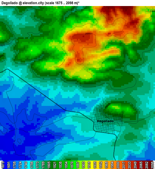
Below is the Elevation map of Degollado, which displays elevation range with different colors. Scale of the first map is from 1675 to 2098 m (5495 to 6883 ft) with average elevation of 1805.5 meters (=5924 ft) [note 1]
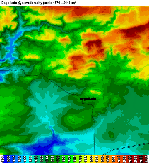
These maps also provides idea of topography and contour of this city, they are displayed at different zoom levels. More info about maps, scale and edge coordinates you can find below images.
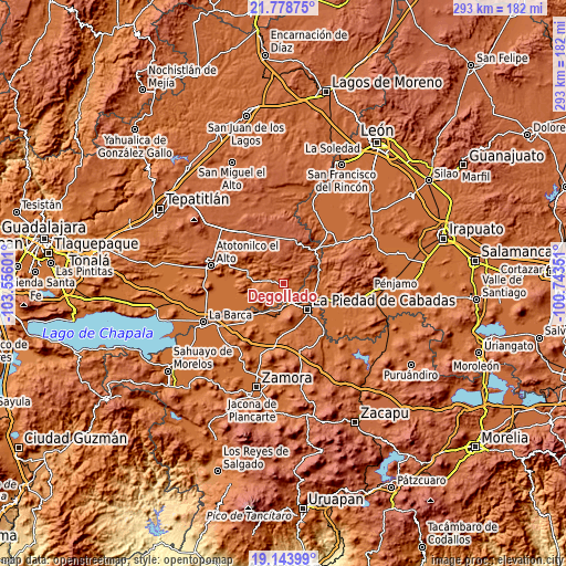
| \ | Map #1 | Map #2 | Topo.Map |
| Scale [m] | 1675..2098 m | 1574..2116 m | × |
| Scale [ft] | 5495..6883 ft | 5164..6942 ft | × |
| Average | 1805.5 m = 5924 ft | 1794.2 m = 5886 ft | × |
| Width | 9.16 km = 5.7 mi | 18.31 km = 11.4 mi | 293 km = 182.1 mi |
| Height | 9.16 km = 5.7 mi | 18.31 km = 11.4 mi | 293 km = 182.1 mi |
| ↑Max Latitude | 20.508186° | 20.54934° | 21.77875° |
| Latitude at center | 20.46702° | 20.46702° | 20.46702° |
| ↓Min Latitude | 20.425843° | 20.384656° | 19.14399° |
| ← Min Longitude | -102.193705° | -102.237651° | -103.55601° |
| Longitude center | -102.14976° | -102.14976° | -102.14976° |
| →Max Longitude | -102.105815° | -102.061869° | -100.74351° |
Nearby cities:
Cities around Degollado sort by population:
• La Piedad elevation 1698 m
18.6 km,  138°
138°
• Yurécuaro 1546 m
20.2 km,  223°
223°
• Ayotlán 1618 m
19.6 km,  290°
290°
• Santa Ana Pacueco 1686 m
19.3 km,  133°
133°
• Jesús María 2097 m
17.2 km,  333°
333°
• La Ribera 1555 m
19.1 km,  226°
226°
• Río Grande 1678 m
20.3 km, 132°
• Huáscato 1617 m
10.3 km,  277°
277°
• El Fuerte 1673 m
13.6 km, 140°
• Monteleón 1569 m
18.7 km,  199°
199°
• Estación la Piedad 1681 m
19.3 km,  124°
124°
• San José de la Paz 1918 m
13.3 km,  45°
45°
Multilingual:
 En español:
Degollado elevación 1793 m.
 En France:
Degollado élévation 1793 m.
 Auf Deutsch:
Degollado höhe über dem Meeresspiegel ist 1793 m.

Sources and notes:
- [note 1] Map square and city borders are not equal. Map elevation data is calculated only from area inside that square.
- [src 1] Elevation data from geonames database provided with same terms of usage.
- [src 2] The elevation map of Degollado is generated using elevation data from NASA's 3 arcsec (90m) resolution SRTM data.
- [src 3] Base (background) map © OpenStreetMap contributors tiles are generated by Geofabrik and OpenTopoMap.
Copyright & License:
This Degollado Elevation Map is licensed under CC BY-SA. You may reuse any part from this page, if you give a proper credit by linking to this URL:
 More info on terms of use page.