La Ribera elevation
La Ribera (Jalisco, Ayotlán), Mexico elevation is 1555 meters and La Ribera elevation in feet is 5102 ft above sea level [src 1]. La Ribera is a populated place (feature code) with elevation that is 241 meters (791 ft) bigger than average city elevation in Mexico.
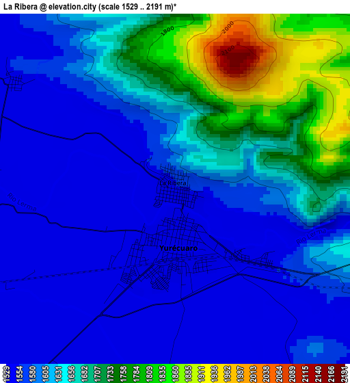
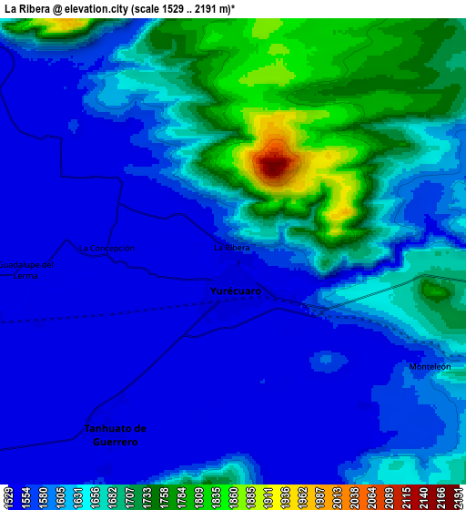
Below is the Elevation map of La Ribera, which displays elevation range with different colors. Scale of the first map is from 1529 to 2191 m (5016 to 7188 ft) with average elevation of 1629.7 meters (=5347 ft) [note 1]
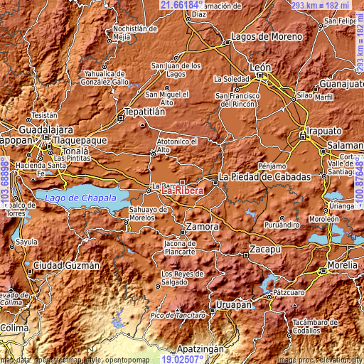
These maps also provides idea of topography and contour of this city, they are displayed at different zoom levels. More info about maps, scale and edge coordinates you can find below images.
| \ | Map #1 | Map #2 | Topo.Map |
| Scale [m] | 1529..2191 m | 1529..2191 m | × |
| Scale [ft] | 5016..7188 ft | 5016..7188 ft | × |
| Average | 1629.7 m = 5347 ft | 1625.4 m = 5333 ft | × |
| Width | 9.16 km = 5.7 mi | 18.33 km = 11.4 mi | 293.2 km = 182.2 mi |
| Height | 9.16 km = 5.7 mi | 18.33 km = 11.4 mi | 293.2 km = 182.2 mi |
| ↑Max Latitude | 20.390277° | 20.431463° | 21.66184° |
| Latitude at center | 20.34908° | 20.34908° | 20.34908° |
| ↓Min Latitude | 20.307872° | 20.266653° | 19.02507° |
| ← Min Longitude | -102.326675° | -102.370621° | -103.68898° |
| Longitude center | -102.28273° | -102.28273° | -102.28273° |
| →Max Longitude | -102.238785° | -102.194839° | -100.87648° |
Nearby cities:
Cities around La Ribera sort by population:
• Yurécuaro elevation 1546 m
1.5 km,  184°
184°
• Tanhuato de Guerrero 1545 m
8.7 km,  215°
215°
• Santa Rita 1565 m
15.2 km,  312°
312°
• San Antonio de Rivas 1538 m
15.1 km,  270°
270°
• La Concepción 1543 m
4.9 km, 273°
• Huáscato 1617 m
14.9 km,  13°
13°
• Las Cieneguitas 1545 m
11.8 km,  160°
160°
• Monteleón 1569 m
9 km,  120°
120°
• Los Pilares 1541 m
9.8 km,  254°
254°
• El Tequesquite 1544 m
5.3 km,  186°
186°
• Guadalupe de Lerma 1541 m
8.2 km,  263°
263°
• El Carmen 1545 m
15.6 km,  294°
294°
Multilingual:
 En español:
La Ribera elevación 1555 m.
 En France:
La Ribera élévation 1555 m.
 Auf Deutsch:
La Ribera höhe über dem Meeresspiegel ist 1555 m.

Sources and notes:
- [note 1] Map square and city borders are not equal. Map elevation data is calculated only from area inside that square.
- [src 1] Elevation data from geonames database provided with same terms of usage.
- [src 2] The elevation map of La Ribera is generated using elevation data from NASA's 3 arcsec (90m) resolution SRTM data.
- [src 3] Base (background) map © OpenStreetMap contributors tiles are generated by Geofabrik and OpenTopoMap.
Copyright & License:
This La Ribera Elevation Map is licensed under CC BY-SA. You may reuse any part from this page, if you give a proper credit by linking to this URL:
 More info on terms of use page.