Tanhuato de Guerrero elevation
Tanhuato de Guerrero (Michoacán, Tanhuato), Mexico elevation is 1545 meters and Tanhuato de Guerrero elevation in feet is 5069 ft above sea level [src 1]. Tanhuato de Guerrero is a seat of a second-order administrative division (feature code) with elevation that is 231 meters (758 ft) bigger than average city elevation in Mexico.
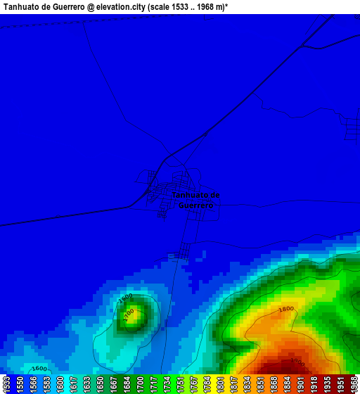
Below is the Elevation map of Tanhuato de Guerrero, which displays elevation range with different colors. Scale of the first map is from 1533 to 1968 m (5030 to 6457 ft) with average elevation of 1573.5 meters (=5162 ft) [note 1]
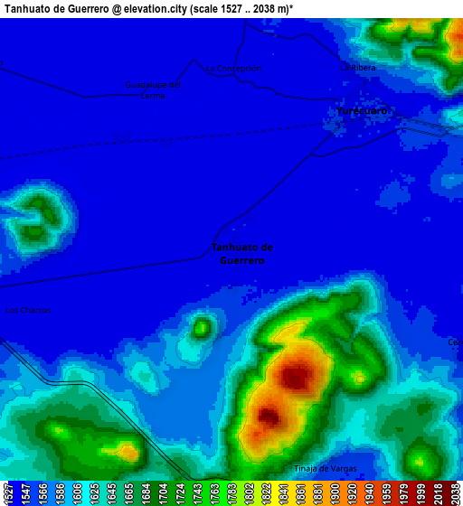
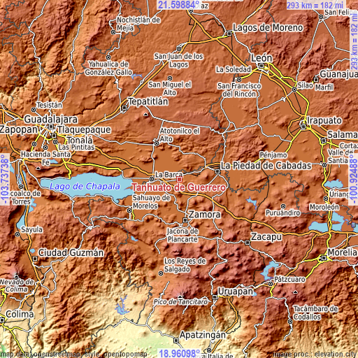
These maps also provides idea of topography and contour of this city, they are displayed at different zoom levels. More info about maps, scale and edge coordinates you can find below images.
| \ | Map #1 | Map #2 | Topo.Map |
| Scale [m] | 1533..1968 m | 1527..2038 m | × |
| Scale [ft] | 5030..6457 ft | 5010..6686 ft | × |
| Average | 1573.5 m = 5162 ft | 1591.4 m = 5221 ft | × |
| Width | 9.17 km = 5.7 mi | 18.33 km = 11.4 mi | 293.3 km = 182.2 mi |
| Height | 9.17 km = 5.7 mi | 18.33 km = 11.4 mi | 293.3 km = 182.2 mi |
| ↑Max Latitude | 20.326734° | 20.367937° | 21.59884° |
| Latitude at center | 20.28552° | 20.28552° | 20.28552° |
| ↓Min Latitude | 20.244295° | 20.203059° | 18.96098° |
| ← Min Longitude | -102.375075° | -102.419021° | -103.73738° |
| Longitude center | -102.33113° | -102.33113° | -102.33113° |
| →Max Longitude | -102.287185° | -102.243239° | -100.92488° |
Nearby cities:
Cities around Tanhuato de Guerrero sort by population:
• Yurécuaro elevation 1546 m
7.5 km,  41°
41°
• La Ribera 1555 m
8.7 km, 35°
• San Antonio de Rivas 1538 m
12.4 km,  305°
305°
• El Alvareño 1535 m
11.2 km,  278°
278°
• La Concepción 1543 m
7.4 km,  1°
1°
• Los Charcos 1543 m
8.4 km,  253°
253°
• Las Cieneguitas 1545 m
9.9 km,  114°
114°
• Monteleón 1569 m
13.1 km,  78°
78°
• Los Pilares 1541 m
6.3 km,  315°
315°
• El Cuenqueño 1539 m
14 km,  289°
289°
• El Tequesquite 1544 m
4.8 km,  67°
67°
• Guadalupe de Lerma 1541 m
6.9 km,  333°
333°
Multilingual:
 En español:
Tanhuato de Guerrero elevación 1545 m.
 En France:
Tanhuato de Guerrero élévation 1545 m.
 Auf Deutsch:
Tanhuato de Guerrero höhe über dem Meeresspiegel ist 1545 m.
 На русском:
Tanhuato de Guerrero высота над уровнем моря 1545 м
Sources and notes:
- [note 1] Map square and city borders are not equal. Map elevation data is calculated only from area inside that square.
- [src 1] Elevation data from geonames database provided with same terms of usage.
- [src 2] The elevation map of Tanhuato de Guerrero is generated using elevation data from NASA's 3 arcsec (90m) resolution SRTM data.
- [src 3] Base (background) map © OpenStreetMap contributors tiles are generated by Geofabrik and OpenTopoMap.
Copyright & License:
This Tanhuato de Guerrero Elevation Map is licensed under CC BY-SA. You may reuse any part from this page, if you give a proper credit by linking to this URL:
 More info on terms of use page.