La Joya de Calvillo elevation
La Joya de Calvillo (Guanajuato, Abasolo), Mexico elevation is 1776 meters and La Joya de Calvillo elevation in feet is 5827 ft above sea level [src 1]. La Joya de Calvillo is a populated place (feature code) with elevation that is 462 meters (1516 ft) bigger than average city elevation in Mexico.
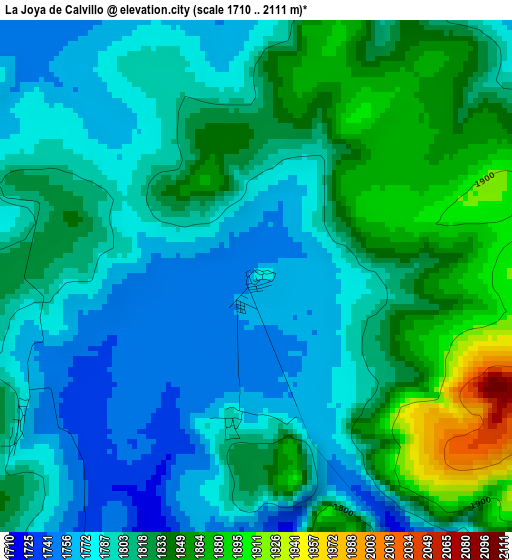
Below is the Elevation map of La Joya de Calvillo, which displays elevation range with different colors. Scale of the first map is from 1710 to 2111 m (5610 to 6926 ft) with average elevation of 1810.3 meters (=5939 ft) [note 1]
These maps also provides idea of topography and contour of this city, they are displayed at different zoom levels. More info about maps, scale and edge coordinates you can find below images.
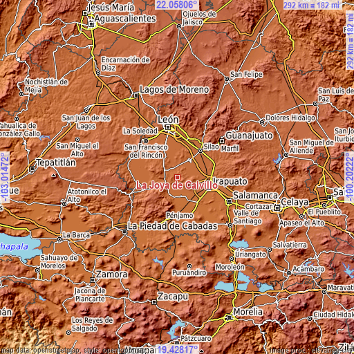
| \ | Map #1 | Topo.Map |
| Scale [m] | 1710..2111 m | × |
| Scale [ft] | 5610..6926 ft | × |
| Average | 1810.3 m = 5939 ft | × |
| Width | 9.14 km = 5.7 mi | 292.4 km = 181.7 mi |
| Height | 9.14 km = 5.7 mi | 292.4 km = 181.7 mi |
| ↑Max Latitude | 20.78992° | 22.05806° |
| Latitude at center | 20.74883° | 20.74883° |
| ↓Min Latitude | 20.707729° | 19.42817° |
| ← Min Longitude | -101.652415° | -103.01472° |
| Longitude center | -101.60847° | -101.60847° |
| →Max Longitude | -101.564525° | -100.20222° |
Nearby cities:
Cities around La Joya de Calvillo sort by population:
• Romita elevation 1752 m
16.6 km,  34°
34°
• Cuerámaro 1727 m
15.2 km,  205°
205°
• San Cristóbal 1727 m
17 km,  126°
126°
• Rancho Nuevo de la Cruz 1729 m
14.4 km,  139°
139°
• Mezquite Gordo 1741 m
14.1 km,  58°
58°
• Gavia de Rionda 1777 m
9.5 km,  354°
354°
• Loma de la Esperanza 1719 m
11.3 km,  151°
151°
• Tupataro 1710 m
17.5 km,  192°
192°
• Las Masas (La Luz Masas) 1699 m
18 km,  157°
157°
• Santa Rosa de Rivas 1754 m
8.3 km, 64°
• La Sardina 1761 m
15.8 km,  338°
338°
• Las Liebres 1745 m
17.3 km, 56°
Multilingual:
 En español:
La Joya de Calvillo elevación 1776 m.
 En France:
La Joya de Calvillo élévation 1776 m.
 Auf Deutsch:
La Joya de Calvillo höhe über dem Meeresspiegel ist 1776 m.
 На русском:
La Joya de Calvillo высота над уровнем моря 1776 м
Sources and notes:
- [note 1] Map square and city borders are not equal. Map elevation data is calculated only from area inside that square.
- [src 1] Elevation data from geonames database provided with same terms of usage.
- [src 2] The elevation map of La Joya de Calvillo is generated using elevation data from NASA's 3 arcsec (90m) resolution SRTM data.
- [src 3] Base (background) map © OpenStreetMap contributors tiles are generated by Geofabrik and OpenTopoMap.
Copyright & License:
This La Joya de Calvillo Elevation Map is licensed under CC BY-SA. You may reuse any part from this page, if you give a proper credit by linking to this URL:
 More info on terms of use page.