Romita elevation
Romita (Guanajuato), Mexico elevation is 1752 meters and Romita elevation in feet is 5748 ft above sea level [src 1]. Romita is a seat of a second-order administrative division (feature code) with elevation that is 438 meters (1437 ft) bigger than average city elevation in Mexico.
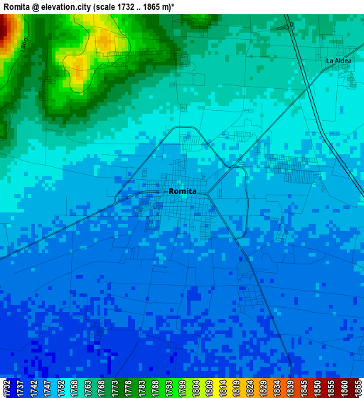
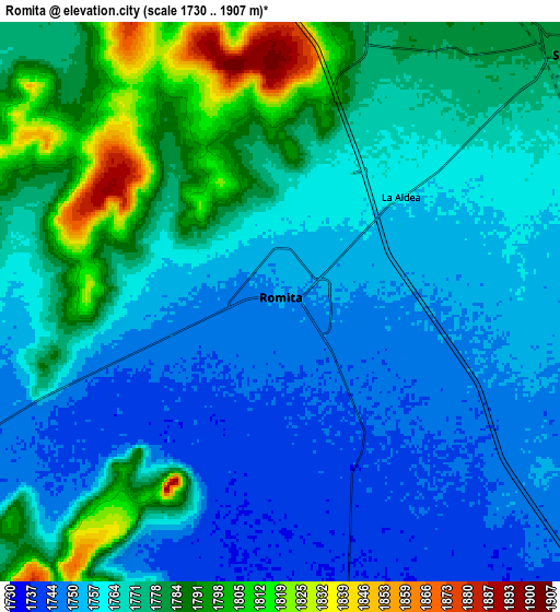
Below is the Elevation map of Romita, which displays elevation range with different colors. Scale of the first map is from 1732 to 1865 m (5682 to 6119 ft) with average elevation of 1754.5 meters (=5756 ft) [note 1]
These maps also provides idea of topography and contour of this city, they are displayed at different zoom levels. More info about maps, scale and edge coordinates you can find below images.
| \ | Map #1 | Map #2 | Topo.Map |
| Scale [m] | 1732..1865 m | 1730..1907 m | × |
| Scale [ft] | 5682..6119 ft | 5676..6257 ft | × |
| Average | 1754.5 m = 5756 ft | 1768.3 m = 5802 ft | × |
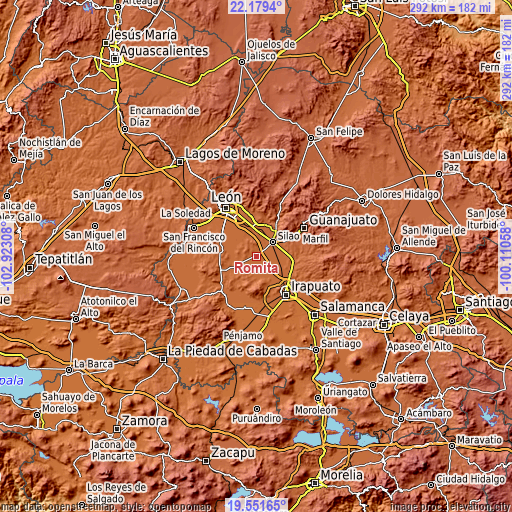
| Width | 9.13 km = 5.7 mi | 18.26 km = 11.3 mi | 292.2 km = 181.6 mi |
| Height | 9.13 km = 5.7 mi | 18.26 km = 11.3 mi | 292.2 km = 181.6 mi |
| ↑Max Latitude | 20.912326° | 20.953371° | 22.1794° |
| Latitude at center | 20.87127° | 20.87127° | 20.87127° |
| ↓Min Latitude | 20.830203° | 20.789124° | 19.55165° |
| ← Min Longitude | -101.560775° | -101.604721° | -102.92308° |
| Longitude center | -101.51683° | -101.51683° | -101.51683° |
| →Max Longitude | -101.472885° | -101.428939° | -100.11058° |
Nearby cities:
Cities around Romita sort by population:
• Silao elevation 1780 m
12.3 km,  49°
49°
• La Aldea 1760 m
5.2 km, 49°
• Franco 1780 m
9.8 km,  35°
35°
• Bajío de Bonillas 1787 m
9 km,  14°
14°
• Mezquite Gordo 1741 m
6.8 km,  158°
158°
• Gavia de Rionda 1777 m
11.2 km,  247°
247°
• Los Medranos 1755 m
8.5 km,  81°
81°
• San Diego 1757 m
11.3 km, 80°
• Santa Rosa de Rivas 1754 m
10.2 km,  191°
191°
• Las Liebres 1745 m
6.2 km,  129°
129°
• Colonia Rafael Corrales Ayala 1763 m
3.4 km,  1°
1°
• El Escoplo 1779 m
4.3 km, 7°
Multilingual:
 En español:
Romita elevación 1752 m.
 En France:
Romita élévation 1752 m.


Sources and notes:
- [note 1] Map square and city borders are not equal. Map elevation data is calculated only from area inside that square.
- [src 1] Elevation data from geonames database provided with same terms of usage.
- [src 2] The elevation map of Romita is generated using elevation data from NASA's 3 arcsec (90m) resolution SRTM data.
- [src 3] Base (background) map © OpenStreetMap contributors tiles are generated by Geofabrik and OpenTopoMap.
Copyright & License:
This Romita Elevation Map is licensed under CC BY-SA. You may reuse any part from this page, if you give a proper credit by linking to this URL:
 More info on terms of use page.