La Aldea elevation
La Aldea (Guanajuato, Silao de la Victoria), Mexico elevation is 1760 meters and La Aldea elevation in feet is 5774 ft above sea level [src 1]. La Aldea is a populated place (feature code) with elevation that is 446 meters (1463 ft) bigger than average city elevation in Mexico.
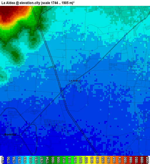
Below is the Elevation map of La Aldea, which displays elevation range with different colors. Scale of the first map is from 1744 to 1905 m (5722 to 6250 ft) with average elevation of 1764.8 meters (=5790 ft) [note 1]
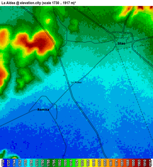
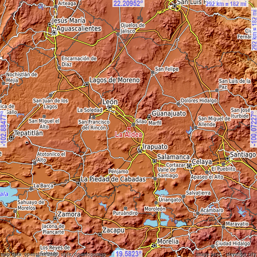
These maps also provides idea of topography and contour of this city, they are displayed at different zoom levels. More info about maps, scale and edge coordinates you can find below images.
| \ | Map #1 | Map #2 | Topo.Map |
| Scale [m] | 1744..1905 m | 1730..1917 m | × |
| Scale [ft] | 5722..6250 ft | 5676..6289 ft | × |
| Average | 1764.8 m = 5790 ft | 1771.9 m = 5813 ft | × |
| Width | 9.13 km = 5.7 mi | 18.26 km = 11.3 mi | 292.1 km = 181.5 mi |
| Height | 9.13 km = 5.7 mi | 18.26 km = 11.3 mi | 292.1 km = 181.5 mi |
| ↑Max Latitude | 20.942708° | 20.983744° | 22.20952° |
| Latitude at center | 20.90166° | 20.90166° | 20.90166° |
| ↓Min Latitude | 20.860601° | 20.819531° | 19.5823° |
| ← Min Longitude | -101.522465° | -101.566411° | -102.88477° |
| Longitude center | -101.47852° | -101.47852° | -101.47852° |
| →Max Longitude | -101.434575° | -101.390629° | -100.07227° |
Nearby cities:
Cities around La Aldea sort by population:
• Silao elevation 1780 m
7.1 km,  48°
48°
• Romita 1752 m
5.2 km,  229°
229°
• Franco 1780 m
4.9 km,  20°
20°
• El Coecillo 1796 m
8.8 km, 19°
• Colonia Nuevo México 1797 m
9.3 km,  355°
355°
• Bajío de Bonillas 1787 m
5.6 km,  341°
341°
• Los Medranos 1755 m
4.9 km,  115°
115°
• San Diego 1757 m
7.3 km,  101°
101°
• Menores 1777 m
8.9 km,  76°
76°
• Las Liebres 1745 m
7.4 km,  173°
173°
• Colonia Rafael Corrales Ayala 1763 m
3.9 km,  270°
270°
• El Escoplo 1779 m
3.5 km,  285°
285°
Multilingual:
 En español:
La Aldea elevación 1760 m.
 En France:
La Aldea élévation 1760 m.
 Auf Deutsch:
La Aldea höhe über dem Meeresspiegel ist 1760 m.

Sources and notes:
- [note 1] Map square and city borders are not equal. Map elevation data is calculated only from area inside that square.
- [src 1] Elevation data from geonames database provided with same terms of usage.
- [src 2] The elevation map of La Aldea is generated using elevation data from NASA's 3 arcsec (90m) resolution SRTM data.
- [src 3] Base (background) map © OpenStreetMap contributors tiles are generated by Geofabrik and OpenTopoMap.
Copyright & License:
This La Aldea Elevation Map is licensed under CC BY-SA. You may reuse any part from this page, if you give a proper credit by linking to this URL:
 More info on terms of use page.