Cuerámaro elevation
Cuerámaro (Guanajuato), Mexico elevation is 1727 meters and Cuerámaro elevation in feet is 5666 ft above sea level [src 1]. Cuerámaro is a seat of a second-order administrative division (feature code) with elevation that is 413 meters (1355 ft) bigger than average city elevation in Mexico.
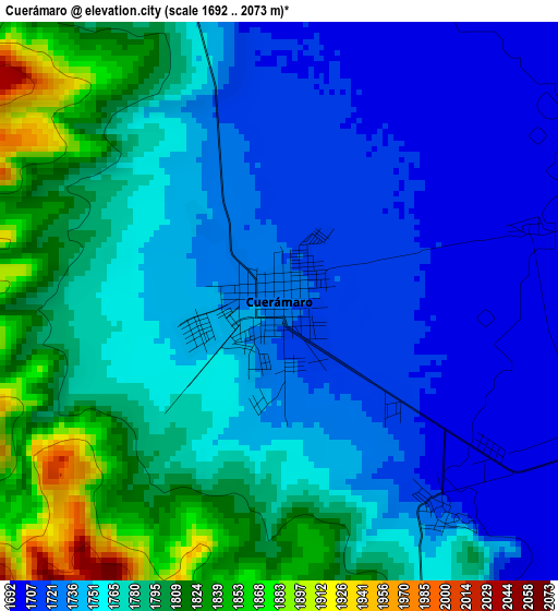
Below is the Elevation map of Cuerámaro, which displays elevation range with different colors. Scale of the first map is from 1692 to 2073 m (5551 to 6801 ft) with average elevation of 1762.3 meters (=5782 ft) [note 1]
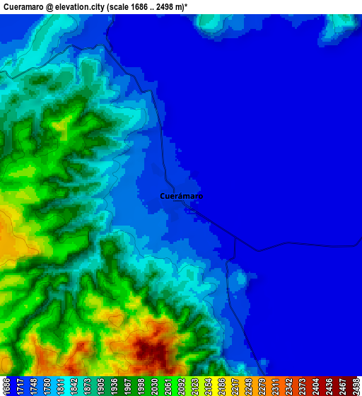
These maps also provides idea of topography and contour of this city, they are displayed at different zoom levels. More info about maps, scale and edge coordinates you can find below images.
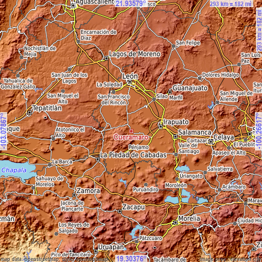
| \ | Map #1 | Map #2 | Topo.Map |
| Scale [m] | 1692..2073 m | 1686..2498 m | × |
| Scale [ft] | 5551..6801 ft | 5531..8196 ft | × |
| Average | 1762.3 m = 5782 ft | 1824.9 m = 5987 ft | × |
| Width | 9.15 km = 5.7 mi | 18.29 km = 11.4 mi | 292.7 km = 181.9 mi |
| Height | 9.15 km = 5.7 mi | 18.29 km = 11.4 mi | 292.7 km = 181.9 mi |
| ↑Max Latitude | 20.666583° | 20.707695° | 21.93579° |
| Latitude at center | 20.62546° | 20.62546° | 20.62546° |
| ↓Min Latitude | 20.584326° | 20.543181° | 19.30376° |
| ← Min Longitude | -101.716365° | -101.760311° | -103.07867° |
| Longitude center | -101.67242° | -101.67242° | -101.67242° |
| →Max Longitude | -101.628475° | -101.584529° | -100.26617° |
Nearby cities:
Cities around Cuerámaro sort by population:
• San Cristóbal elevation 1727 m
20.7 km,  79°
79°
• Rancho Nuevo de la Cruz 1729 m
16.3 km, 79°
• Estación Joaquín 1695 m
17.4 km,  114°
114°
• Huitzatarito 1691 m
18.2 km,  144°
144°
• Loma de la Esperanza 1719 m
12.6 km,  72°
72°
• Tupataro 1710 m
4.3 km, 141°
• Las Masas (La Luz Masas) 1699 m
13.8 km,  102°
102°
• La Joya de Calvillo 1776 m
15.2 km,  25°
25°
• Purísima de Covarrubias 1710 m
19.7 km,  91°
91°
• Zapote de Cestao 1813 m
15.8 km,  181°
181°
• San Gregorio 1706 m
9.9 km,  152°
152°
• Estación Corralejo 1694 m
18.2 km,  161°
161°
Multilingual:
 En español:
Cuerámaro elevación 1727 m.
 En France:
Cuerámaro élévation 1727 m.
 Auf Deutsch:
Cuerámaro höhe über dem Meeresspiegel ist 1727 m.

Sources and notes:
- [note 1] Map square and city borders are not equal. Map elevation data is calculated only from area inside that square.
- [src 1] Elevation data from geonames database provided with same terms of usage.
- [src 2] The elevation map of Cuerámaro is generated using elevation data from NASA's 3 arcsec (90m) resolution SRTM data.
- [src 3] Base (background) map © OpenStreetMap contributors tiles are generated by Geofabrik and OpenTopoMap.
Copyright & License:
This Cuerámaro Elevation Map is licensed under CC BY-SA. You may reuse any part from this page, if you give a proper credit by linking to this URL:
 More info on terms of use page.