San Cristóbal elevation
San Cristóbal (Guanajuato, Irapuato), Mexico elevation is 1727 meters and San Cristóbal elevation in feet is 5666 ft above sea level [src 1]. San Cristóbal is a populated place (feature code) with elevation that is 413 meters (1355 ft) bigger than average city elevation in Mexico.
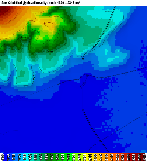
Below is the Elevation map of San Cristóbal, which displays elevation range with different colors. Scale of the first map is from 1699 to 2343 m (5574 to 7687 ft) with average elevation of 1789.6 meters (=5871 ft) [note 1]
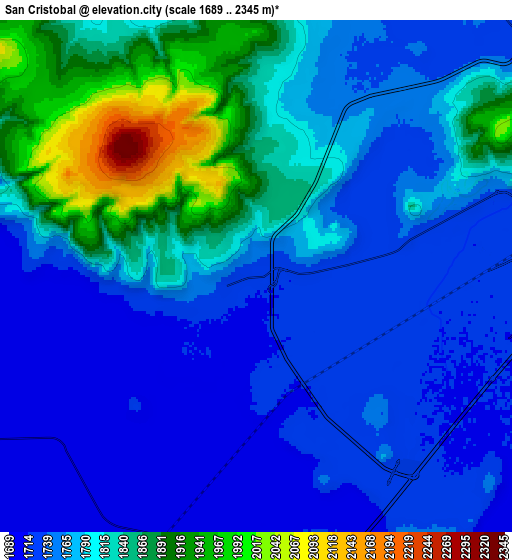
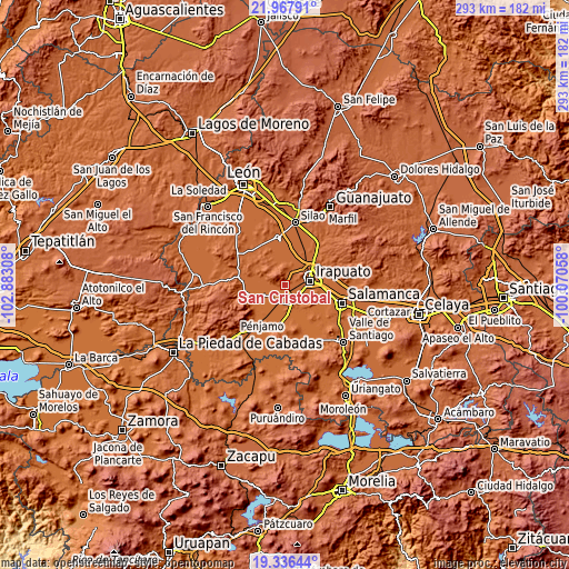
These maps also provides idea of topography and contour of this city, they are displayed at different zoom levels. More info about maps, scale and edge coordinates you can find below images.
| \ | Map #1 | Map #2 | Topo.Map |
| Scale [m] | 1699..2343 m | 1689..2345 m | × |
| Scale [ft] | 5574..7687 ft | 5541..7694 ft | × |
| Average | 1789.6 m = 5871 ft | 1789.2 m = 5870 ft | × |
| Width | 9.14 km = 5.7 mi | 18.29 km = 11.4 mi | 292.6 km = 181.8 mi |
| Height | 9.14 km = 5.7 mi | 18.29 km = 11.4 mi | 292.6 km = 181.8 mi |
| ↑Max Latitude | 20.698984° | 20.740087° | 21.96791° |
| Latitude at center | 20.65787° | 20.65787° | 20.65787° |
| ↓Min Latitude | 20.616745° | 20.575608° | 19.33644° |
| ← Min Longitude | -101.520775° | -101.564721° | -102.88308° |
| Longitude center | -101.47683° | -101.47683° | -101.47683° |
| →Max Longitude | -101.432885° | -101.388939° | -100.07058° |
Nearby cities:
Cities around San Cristóbal sort by population:
• Villas de Irapuato elevation 1781 m
8.1 km,  66°
66°
• Rancho Nuevo de la Cruz 1729 m
4.3 km,  259°
259°
• Cuchicuato 1738 m
1.6 km,  77°
77°
• La Caja 1762 m
7.2 km,  34°
34°
• Loma de la Esperanza 1719 m
8.3 km,  271°
271°
• Fraccionamiento las Liebres 1718 m
8.5 km,  97°
97°
• San Javier 1730 m
5 km, 78°
• Guadalupe de Rivera 1717 m
6 km,  170°
170°
• La Soledad 1716 m
8.5 km,  131°
131°
• Purísima de Covarrubias 1710 m
4.3 km,  189°
189°
• San José de Bernalejo (El Guayabo) 1718 m
8.1 km, 104°
• Colonia Morelos de Guadalupe de Rivera 1734 m
7.5 km,  156°
156°
Multilingual:
 En español:
San Cristóbal elevación 1727 m.
 En France:
San Cristóbal élévation 1727 m.
 Auf Deutsch:
San Cristóbal höhe über dem Meeresspiegel ist 1727 m.

Sources and notes:
- [note 1] Map square and city borders are not equal. Map elevation data is calculated only from area inside that square.
- [src 1] Elevation data from geonames database provided with same terms of usage.
- [src 2] The elevation map of San Cristóbal is generated using elevation data from NASA's 3 arcsec (90m) resolution SRTM data.
- [src 3] Base (background) map © OpenStreetMap contributors tiles are generated by Geofabrik and OpenTopoMap.
Copyright & License:
This San Cristóbal Elevation Map is licensed under CC BY-SA. You may reuse any part from this page, if you give a proper credit by linking to this URL:
 More info on terms of use page.