Presa del Rosario elevation
Presa del Rosario (Michoacán, Apatzingán), Mexico elevation is 266 meters and Presa del Rosario elevation in feet is 873 ft above sea level [src 1]. Presa del Rosario is a populated place (feature code) with elevation that is 1048 meters (3438 ft) smaller than average city elevation in Mexico.
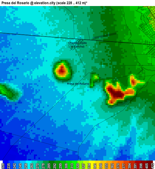
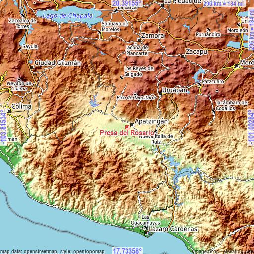
Below is the Elevation map of Presa del Rosario, which displays elevation range with different colors. Scale of the first map is from 228 to 412 m (748 to 1352 ft) with average elevation of 268.1 meters (=880 ft) [note 1]
These maps also provides idea of topography and contour of this city, they are displayed at different zoom levels. More info about maps, scale and edge coordinates you can find below images.
| \ | Map #1 | Topo.Map |
| Scale [m] | 228..412 m | × |
| Scale [ft] | 748..1352 ft | × |
| Average | 268.1 m = 880 ft | × |
| Width | 9.24 km = 5.7 mi | 295.5 km = 183.6 mi |
| Height | 9.24 km = 5.7 mi | 295.6 km = 183.7 mi |
| ↑Max Latitude | 19.109419° | 20.39155° |
| Latitude at center | 19.06789° | 19.06789° |
| ↓Min Latitude | 19.026351° | 17.73358° |
| ← Min Longitude | -102.453035° | -103.81534° |
| Longitude center | -102.40909° | -102.40909° |
| →Max Longitude | -102.365145° | -101.00284° |
Nearby cities:
Cities around Presa del Rosario sort by population:
• Apatzingán elevation 324 m
5.9 km,  67°
67°
• Antúnez 371 m
22.3 km,  105°
105°
• Santa Ana Amatlán 321 m
17.3 km,  306°
306°
• Paracuaro 610 m
22 km, 65°
• Cenobio Moreno 248 m
10.5 km,  287°
287°
• Pinzándaro 259 m
14.6 km, 288°
• San Juan De Los Platanos 276 m
8.3 km,  337°
337°
• Loma de los Hoyos 242 m
5 km,  224°
224°
• San Juan de los Plátanos 272 m
8.1 km, 337°
• División del Norte 272 m
21.4 km,  274°
274°
• San Antonio la Labor 318 m
12.2 km, 110°
• Uspero 311 m
15.9 km, 112°
Multilingual:
 En español:
Presa del Rosario elevación 266 m.
 En France:
Presa del Rosario élévation 266 m.
 Auf Deutsch:
Presa del Rosario höhe über dem Meeresspiegel ist 266 m.

Sources and notes:
- [note 1] Map square and city borders are not equal. Map elevation data is calculated only from area inside that square.
- [src 1] Elevation data from geonames database provided with same terms of usage.
- [src 2] The elevation map of Presa del Rosario is generated using elevation data from NASA's 3 arcsec (90m) resolution SRTM data.
- [src 3] Base (background) map © OpenStreetMap contributors tiles are generated by Geofabrik and OpenTopoMap.
Copyright & License:
This Presa del Rosario Elevation Map is licensed under CC BY-SA. You may reuse any part from this page, if you give a proper credit by linking to this URL:
 More info on terms of use page.