Santa Ana Amatlán elevation
Santa Ana Amatlán (Michoacán, Buenavista), Mexico elevation is 321 meters and Santa Ana Amatlán elevation in feet is 1053 ft above sea level [src 1]. Santa Ana Amatlán is a populated place (feature code) with elevation that is 993 meters (3258 ft) smaller than average city elevation in Mexico.
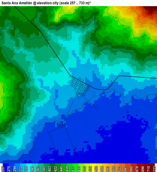
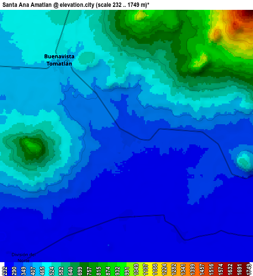
Below is the Elevation map of Santa Ana Amatlán, which displays elevation range with different colors. Scale of the first map is from 257 to 733 m (843 to 2405 ft) with average elevation of 356.8 meters (=1171 ft) [note 1]
These maps also provides idea of topography and contour of this city, they are displayed at different zoom levels. More info about maps, scale and edge coordinates you can find below images.
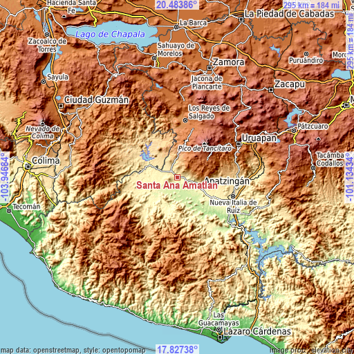
| \ | Map #1 | Map #2 | Topo.Map |
| Scale [m] | 257..733 m | 232..1749 m | × |
| Scale [ft] | 843..2405 ft | 761..5738 ft | × |
| Average | 356.8 m = 1171 ft | 442.2 m = 1451 ft | × |
| Width | 9.23 km = 5.7 mi | 18.46 km = 11.5 mi | 295.4 km = 183.6 mi |
| Height | 9.23 km = 5.7 mi | 18.46 km = 11.5 mi | 295.4 km = 183.6 mi |
| ↑Max Latitude | 19.202476° | 19.243971° | 20.48386° |
| Latitude at center | 19.16097° | 19.16097° | 19.16097° |
| ↓Min Latitude | 19.119454° | 19.077928° | 17.82738° |
| ← Min Longitude | -102.584535° | -102.628481° | -103.94684° |
| Longitude center | -102.54059° | -102.54059° | -102.54059° |
| →Max Longitude | -102.496645° | -102.452699° | -101.13434° |
Nearby cities:
Cities around Santa Ana Amatlán sort by population:
• Buenavista Tomatlán elevation 466 m
7.6 km,  319°
319°
• Felipe Carrillo Puerto 334 m
17.6 km,  270°
270°
• Cenobio Moreno 248 m
8.1 km,  151°
151°
• Pinzándaro 259 m
5.7 km,  180°
180°
• San Juan De Los Platanos 276 m
11 km,  104°
104°
• Dieciocho de Marzo 415 m
19 km,  294°
294°
• Loma de los Hoyos 242 m
17.3 km,  143°
143°
• San Juan de los Plátanos 272 m
11.1 km, 104°
• División del Norte 272 m
11.6 km,  220°
220°
• Presa del Rosario 266 m
17.3 km,  126°
126°
• Tazumbo 559 m
18.4 km, 323°
• Santa Catarina 1782 m
20.7 km,  46°
46°
Multilingual:
 En español:
Santa Ana Amatlán elevación 321 m.
 En France:
Santa Ana Amatlán élévation 321 m.
 Auf Deutsch:
Santa Ana Amatlán höhe über dem Meeresspiegel ist 321 m.

Sources and notes:
- [note 1] Map square and city borders are not equal. Map elevation data is calculated only from area inside that square.
- [src 1] Elevation data from geonames database provided with same terms of usage.
- [src 2] The elevation map of Santa Ana Amatlán is generated using elevation data from NASA's 3 arcsec (90m) resolution SRTM data.
- [src 3] Base (background) map © OpenStreetMap contributors tiles are generated by Geofabrik and OpenTopoMap.
Copyright & License:
This Santa Ana Amatlán Elevation Map is licensed under CC BY-SA. You may reuse any part from this page, if you give a proper credit by linking to this URL:
 More info on terms of use page.