Antúnez elevation
Antúnez (Michoacán, Parácuaro), Mexico elevation is 371 meters and Antúnez elevation in feet is 1217 ft above sea level [src 1]. Antúnez is a populated place (feature code) with elevation that is 943 meters (3094 ft) smaller than average city elevation in Mexico.
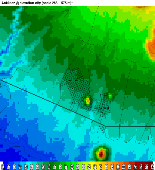
Below is the Elevation map of Antúnez, which displays elevation range with different colors. Scale of the first map is from 283 to 575 m (928 to 1886 ft) with average elevation of 362.3 meters (=1189 ft) [note 1]
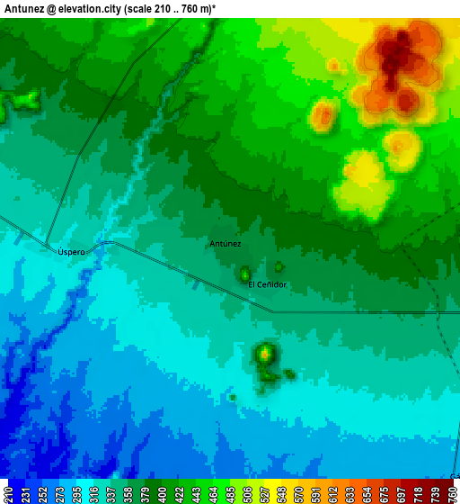
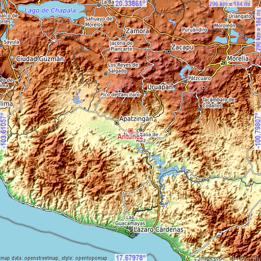
These maps also provides idea of topography and contour of this city, they are displayed at different zoom levels. More info about maps, scale and edge coordinates you can find below images.
| \ | Map #1 | Map #2 | Topo.Map |
| Scale [m] | 283..575 m | 210..760 m | × |
| Scale [ft] | 928..1886 ft | 689..2493 ft | × |
| Average | 362.3 m = 1189 ft | 368.9 m = 1210 ft | × |
| Width | 9.24 km = 5.7 mi | 18.48 km = 11.5 mi | 295.6 km = 183.7 mi |
| Height | 9.24 km = 5.7 mi | 18.48 km = 11.5 mi | 295.7 km = 183.7 mi |
| ↑Max Latitude | 19.056052° | 19.097584° | 20.33861° |
| Latitude at center | 19.01451° | 19.01451° | 19.01451° |
| ↓Min Latitude | 18.972957° | 18.931394° | 17.67978° |
| ← Min Longitude | -102.248265° | -102.292211° | -103.61057° |
| Longitude center | -102.20432° | -102.20432° | -102.20432° |
| →Max Longitude | -102.160375° | -102.116429° | -100.79807° |
Nearby cities:
Cities around Antúnez sort by population:
• Apatzingán elevation 324 m
18 km,  297°
297°
• Nueva Italia de Ruiz 416 m
11.7 km,  84°
84°
• Antúnez (Morelos) 368 m
0.2 km,  166°
166°
• Paracuaro 610 m
15.1 km,  354°
354°
• Gambara 279 m
13.3 km,  133°
133°
• El Ceñidor 357 m
2 km, 131°
• El Letrero 314 m
11.4 km,  119°
119°
• Buenos Aires 481 m
7.2 km,  20°
20°
• El Guaco 458 m
16.5 km,  69°
69°
• Cuatro Caminos 358 m
11 km,  105°
105°
• San Antonio la Labor 318 m
10.3 km,  279°
279°
• Uspero 311 m
6.8 km,  269°
269°
Multilingual:
 En español:
Morelos elevación 371 m.
 En France:
Antúnez élévation 371 m.


Sources and notes:
- [note 1] Map square and city borders are not equal. Map elevation data is calculated only from area inside that square.
- [src 1] Elevation data from geonames database provided with same terms of usage.
- [src 2] The elevation map of Antúnez is generated using elevation data from NASA's 3 arcsec (90m) resolution SRTM data.
- [src 3] Base (background) map © OpenStreetMap contributors tiles are generated by Geofabrik and OpenTopoMap.
Copyright & License:
This Antúnez Elevation Map is licensed under CC BY-SA. You may reuse any part from this page, if you give a proper credit by linking to this URL:
 More info on terms of use page.