San Antonio la Labor elevation
San Antonio la Labor (Michoacán, Apatzingán), Mexico elevation is 318 meters and San Antonio la Labor elevation in feet is 1043 ft above sea level [src 1]. San Antonio la Labor is a populated place (feature code) with elevation that is 996 meters (3268 ft) smaller than average city elevation in Mexico.
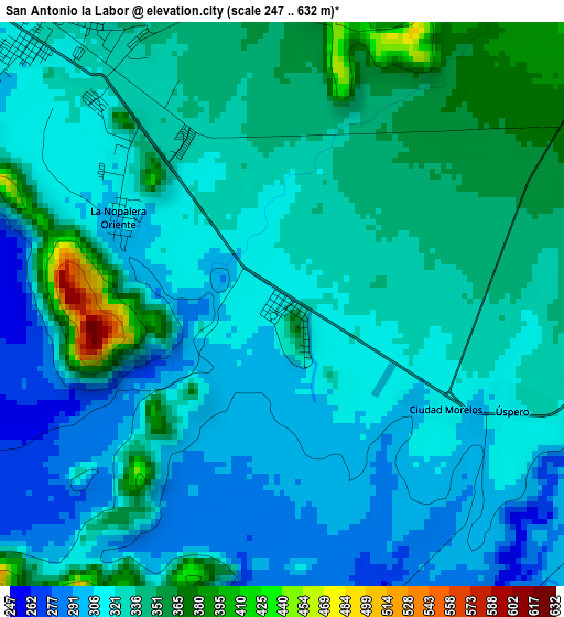
Below is the Elevation map of San Antonio la Labor, which displays elevation range with different colors. Scale of the first map is from 247 to 632 m (810 to 2073 ft) with average elevation of 325.7 meters (=1069 ft) [note 1]
These maps also provides idea of topography and contour of this city, they are displayed at different zoom levels. More info about maps, scale and edge coordinates you can find below images.
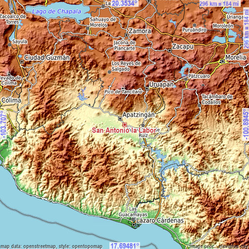
| \ | Map #1 | Topo.Map |
| Scale [m] | 247..632 m | × |
| Scale [ft] | 810..2073 ft | × |
| Average | 325.7 m = 1069 ft | × |
| Width | 9.24 km = 5.7 mi | 295.6 km = 183.7 mi |
| Height | 9.24 km = 5.7 mi | 295.6 km = 183.7 mi |
| ↑Max Latitude | 19.070959° | 20.3534° |
| Latitude at center | 19.02942° | 19.02942° |
| ↓Min Latitude | 18.987871° | 17.69481° |
| ← Min Longitude | -102.344695° | -103.707° |
| Longitude center | -102.30075° | -102.30075° |
| →Max Longitude | -102.256805° | -100.8945° |
Nearby cities:
Cities around San Antonio la Labor sort by population:
• Apatzingán elevation 324 m
8.9 km,  318°
318°
• Antúnez (Morelos) 368 m
10.3 km,  100°
100°
• Antúnez 371 m
10.3 km, 99°
• Paracuaro 610 m
15.9 km,  32°
32°
• El Ceñidor 357 m
12 km, 104°
• San Juan De Los Platanos 276 m
18.8 km,  309°
309°
• Loma de los Hoyos 242 m
14.9 km,  272°
272°
• Buenos Aires 481 m
13.7 km,  68°
68°
• San Juan de los Plátanos 272 m
18.7 km, 309°
• Presa del Rosario 266 m
12.2 km,  290°
290°
• Cuatro Caminos 358 m
21.2 km, 102°
• Uspero 311 m
3.7 km,  116°
116°
Multilingual:
 En español:
San Antonio la Labor elevación 318 m.
 En France:
San Antonio la Labor élévation 318 m.
 Auf Deutsch:
San Antonio la Labor höhe über dem Meeresspiegel ist 318 m.
 На русском:
San Antonio la Labor высота над уровнем моря 318 м
Sources and notes:
- [note 1] Map square and city borders are not equal. Map elevation data is calculated only from area inside that square.
- [src 1] Elevation data from geonames database provided with same terms of usage.
- [src 2] The elevation map of San Antonio la Labor is generated using elevation data from NASA's 3 arcsec (90m) resolution SRTM data.
- [src 3] Base (background) map © OpenStreetMap contributors tiles are generated by Geofabrik and OpenTopoMap.
Copyright & License:
This San Antonio la Labor Elevation Map is licensed under CC BY-SA. You may reuse any part from this page, if you give a proper credit by linking to this URL:
 More info on terms of use page.