San Antonio del Rosario elevation
San Antonio del Rosario (State of Mexico, Tlatlaya), Mexico elevation is 385 meters and San Antonio del Rosario elevation in feet is 1263 ft above sea level [src 1]. San Antonio del Rosario is a populated place (feature code) with elevation that is 929 meters (3048 ft) smaller than average city elevation in Mexico.
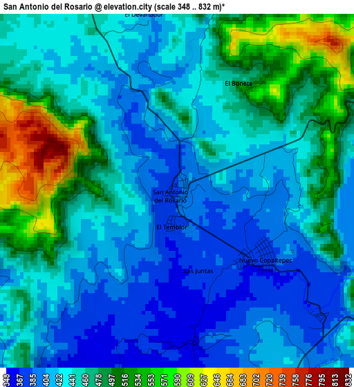
Below is the Elevation map of San Antonio del Rosario, which displays elevation range with different colors. Scale of the first map is from 348 to 832 m (1142 to 2730 ft) with average elevation of 449.5 meters (=1475 ft) [note 1]
These maps also provides idea of topography and contour of this city, they are displayed at different zoom levels. More info about maps, scale and edge coordinates you can find below images.
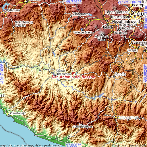
| \ | Map #1 | Topo.Map |
| Scale [m] | 348..832 m | × |
| Scale [ft] | 1142..2730 ft | × |
| Average | 449.5 m = 1475 ft | × |
| Width | 9.27 km = 5.8 mi | 296.7 km = 184.4 mi |
| Height | 9.27 km = 5.8 mi | 296.7 km = 184.4 mi |
| ↑Max Latitude | 18.441814° | 19.7292° |
| Latitude at center | 18.40012° | 18.40012° |
| ↓Min Latitude | 18.358416° | 17.0607° |
| ← Min Longitude | -100.352685° | -101.71499° |
| Longitude center | -100.30874° | -100.30874° |
| →Max Longitude | -100.264795° | -98.90249° |
Nearby cities:
Cities around San Antonio del Rosario sort by population:
• Arcelia elevation 393 m
9.5 km,  162°
162°
• San Miguel Totolapan 302 m
27.9 km,  198°
198°
• Tlalchapa 409 m
17.7 km,  273°
273°
• San José Poliutla 310 m
16.6 km,  211°
211°
• San Pedro Limón 668 m
20.2 km,  0°
0°
• San Antonio de las Huertas 364 m
25.7 km,  239°
239°
• Acapetlahuaya 1181 m
25 km,  85°
85°
• Santa Ana Zicatecoyan 998 m
21.2 km,  26°
26°
• Villa Madero 413 m
14.8 km, 274°
• El Escondido 368 m
20 km,  181°
181°
• Villa Hidalgo (El Cubo) 304 m
26.5 km, 181°
• Tlatlaya 1826 m
26.4 km,  23°
23°
Multilingual:
 En español:
San Antonio del Rosario elevación 385 m.
 En France:
San Antonio del Rosario élévation 385 m.
 Auf Deutsch:
San Antonio del Rosario höhe über dem Meeresspiegel ist 385 m.
 На русском:
San Antonio del Rosario высота над уровнем моря 385 м
Sources and notes:
- [note 1] Map square and city borders are not equal. Map elevation data is calculated only from area inside that square.
- [src 1] Elevation data from geonames database provided with same terms of usage.
- [src 2] The elevation map of San Antonio del Rosario is generated using elevation data from NASA's 3 arcsec (90m) resolution SRTM data.
- [src 3] Base (background) map © OpenStreetMap contributors tiles are generated by Geofabrik and OpenTopoMap.
Copyright & License:
This San Antonio del Rosario Elevation Map is licensed under CC BY-SA. You may reuse any part from this page, if you give a proper credit by linking to this URL:
 More info on terms of use page.