San Pedro Limón elevation
San Pedro Limón (State of Mexico, Tlatlaya), Mexico elevation is 668 meters and San Pedro Limón elevation in feet is 2192 ft above sea level [src 1]. San Pedro Limón is a populated place (feature code) with elevation that is 646 meters (2119 ft) smaller than average city elevation in Mexico.
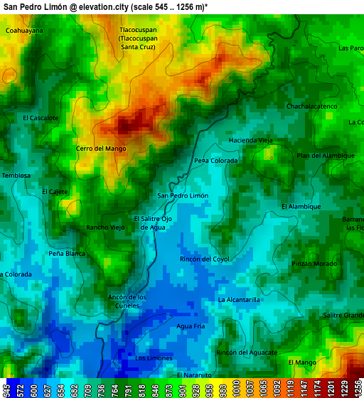
Below is the Elevation map of San Pedro Limón, which displays elevation range with different colors. Scale of the first map is from 545 to 1256 m (1788 to 4121 ft) with average elevation of 786.7 meters (=2581 ft) [note 1]
These maps also provides idea of topography and contour of this city, they are displayed at different zoom levels. More info about maps, scale and edge coordinates you can find below images.
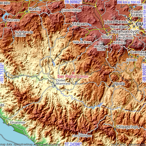
| \ | Map #1 | Topo.Map |
| Scale [m] | 545..1256 m | × |
| Scale [ft] | 1788..4121 ft | × |
| Average | 786.7 m = 2581 ft | × |
| Width | 9.26 km = 5.8 mi | 296.4 km = 184.2 mi |
| Height | 9.26 km = 5.8 mi | 296.4 km = 184.2 mi |
| ↑Max Latitude | 18.623649° | 19.90962° |
| Latitude at center | 18.582° | 18.582° |
| ↓Min Latitude | 18.540341° | 17.24396° |
| ← Min Longitude | -100.351015° | -101.71332° |
| Longitude center | -100.30707° | -100.30707° |
| →Max Longitude | -100.263125° | -98.90082° |
Nearby cities:
Cities around San Pedro Limón sort by population:
• Arcelia elevation 393 m
29.4 km,  174°
174°
• Cutzamala de Pinzón 282 m
31.5 km,  246°
246°
• Tlalchapa 409 m
26.1 km,  223°
223°
• Palmar Chico 789 m
14.2 km,  332°
332°
• Bejucos 539 m
25.2 km, 329°
• Amatepec 1813 m
17 km,  48°
48°
• Acapetlahuaya 1181 m
30.6 km,  126°
126°
• Santa Ana Zicatecoyan 998 m
9.2 km,  97°
97°
• San Antonio del Rosario 385 m
20.2 km,  180°
180°
• Villa Madero 413 m
24.2 km, 218°
• San Miguel Ixtapan 1013 m
29.9 km,  33°
33°
• Tlatlaya 1826 m
11.2 km,  69°
69°
Multilingual:
 En español:
San Pedro Limón elevación 668 m.
 En France:
San Pedro Limón élévation 668 m.
 Auf Deutsch:
San Pedro Limón höhe über dem Meeresspiegel ist 668 m.

Sources and notes:
- [note 1] Map square and city borders are not equal. Map elevation data is calculated only from area inside that square.
- [src 1] Elevation data from geonames database provided with same terms of usage.
- [src 2] The elevation map of San Pedro Limón is generated using elevation data from NASA's 3 arcsec (90m) resolution SRTM data.
- [src 3] Base (background) map © OpenStreetMap contributors tiles are generated by Geofabrik and OpenTopoMap.
Copyright & License:
This San Pedro Limón Elevation Map is licensed under CC BY-SA. You may reuse any part from this page, if you give a proper credit by linking to this URL:
 More info on terms of use page.