Villa Madero elevation
Villa Madero (Guerrero, Tlalchapa), Mexico elevation is 413 meters and Villa Madero elevation in feet is 1355 ft above sea level [src 1]. Villa Madero is a populated place (feature code) with elevation that is 901 meters (2956 ft) smaller than average city elevation in Mexico.
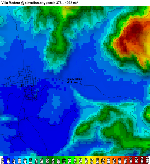
Below is the Elevation map of Villa Madero, which displays elevation range with different colors. Scale of the first map is from 376 to 1092 m (1234 to 3583 ft) with average elevation of 502.1 meters (=1647 ft) [note 1]
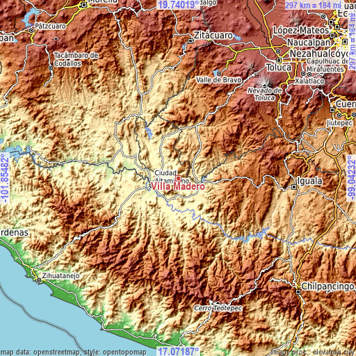
These maps also provides idea of topography and contour of this city, they are displayed at different zoom levels. More info about maps, scale and edge coordinates you can find below images.
| \ | Map #1 | Topo.Map |
| Scale [m] | 376..1092 m | × |
| Scale [ft] | 1234..3583 ft | × |
| Average | 502.1 m = 1647 ft | × |
| Width | 9.27 km = 5.8 mi | 296.7 km = 184.4 mi |
| Height | 9.27 km = 5.8 mi | 296.7 km = 184.4 mi |
| ↑Max Latitude | 18.452891° | 19.74019° |
| Latitude at center | 18.4112° | 18.4112° |
| ↓Min Latitude | 18.369499° | 17.07187° |
| ← Min Longitude | -100.492515° | -101.85482° |
| Longitude center | -100.44857° | -100.44857° |
| →Max Longitude | -100.404625° | -99.04232° |
Nearby cities:
Cities around Villa Madero sort by population:
• Arcelia elevation 393 m
20.4 km,  120°
120°
• Tlapehuala 281 m
21.1 km,  206°
206°
• Cutzamala de Pinzón 282 m
15.3 km,  294°
294°
• Tlalchapa 409 m
2.9 km,  267°
267°
• San José Poliutla 310 m
16.5 km,  158°
158°
• Changata 266 m
21.1 km,  223°
223°
• San Antonio de las Huertas 364 m
16.2 km, 207°
• Querendas 262 m
21 km,  248°
248°
• San Antonio del Rosario 385 m
14.8 km,  94°
94°
• Sinahua 263 m
21.6 km,  227°
227°
• Salguero 275 m
18.7 km, 270°
• Morelita 274 m
19.9 km, 217°
Multilingual:
 En español:
Villa Madero, El Potrero elevación 413 m.
 En France:
Villa Madero élévation 413 m.
 Auf Deutsch:
Villa Madero höhe über dem Meeresspiegel ist 413 m.

Sources and notes:
- [note 1] Map square and city borders are not equal. Map elevation data is calculated only from area inside that square.
- [src 1] Elevation data from geonames database provided with same terms of usage.
- [src 2] The elevation map of Villa Madero is generated using elevation data from NASA's 3 arcsec (90m) resolution SRTM data.
- [src 3] Base (background) map © OpenStreetMap contributors tiles are generated by Geofabrik and OpenTopoMap.
Copyright & License:
This Villa Madero Elevation Map is licensed under CC BY-SA. You may reuse any part from this page, if you give a proper credit by linking to this URL:
 More info on terms of use page.