Sinahua elevation
Sinahua (Guerrero, Pungarabato), Mexico elevation is 263 meters and Sinahua elevation in feet is 863 ft above sea level [src 1]. Sinahua is a populated place (feature code) with elevation that is 1051 meters (3448 ft) smaller than average city elevation in Mexico.
Below is the Elevation map of Sinahua, which displays elevation range with different colors. Scale of the first map is from 241 to 1126 m (791 to 3694 ft) with average elevation of 346.4 meters (=1136 ft) [note 1]
These maps also provides idea of topography and contour of this city, they are displayed at different zoom levels. More info about maps, scale and edge coordinates you can find below images.
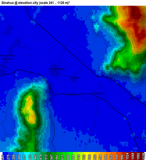
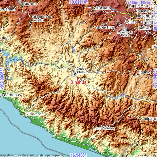
| \ | Map #1 | Topo.Map |
| Scale [m] | 241..1126 m | × |
| Scale [ft] | 791..3694 ft | × |
| Average | 346.4 m = 1136 ft | × |
| Width | 9.28 km = 5.8 mi | 296.9 km = 184.5 mi |
| Height | 9.28 km = 5.8 mi | 296.9 km = 184.5 mi |
| ↑Max Latitude | 18.322832° | 19.61114° |
| Latitude at center | 18.28111° | 18.28111° |
| ↓Min Latitude | 18.239378° | 16.9408° |
| ← Min Longitude | -100.644225° | -102.00653° |
| Longitude center | -100.60028° | -100.60028° |
| →Max Longitude | -100.556335° | -99.19403° |
Nearby cities:
Cities around Sinahua sort by population:
• Tlapehuala elevation 281 m
8 km,  124°
124°
• Tanganhuato 262 m
1.3 km,  294°
294°
• Corral Falso 273 m
5.9 km,  133°
133°
• Changata 266 m
1.8 km, 119°
• Amuco de la Reforma 259 m
4.4 km, 288°
• Villa Nicolás Bravo 278 m
9.3 km,  143°
143°
• San Antonio de las Huertas 364 m
8.7 km,  89°
89°
• Querendas 262 m
7.7 km,  332°
332°
• Nuevo Guerrero 272 m
10 km, 128°
• Morelita 274 m
4 km,  107°
107°
• Santa Bárbara 259 m
6.9 km,  322°
322°
• San Lorenzo 257 m
1.4 km,  233°
233°
Multilingual:
 En español:
Sinahua elevación 263 m.
 En France:
Sinahua élévation 263 m.


Sources and notes:
- [note 1] Map square and city borders are not equal. Map elevation data is calculated only from area inside that square.
- [src 1] Elevation data from geonames database provided with same terms of usage.
- [src 2] The elevation map of Sinahua is generated using elevation data from NASA's 3 arcsec (90m) resolution SRTM data.
- [src 3] Base (background) map © OpenStreetMap contributors tiles are generated by Geofabrik and OpenTopoMap.
Copyright & License:
This Sinahua Elevation Map is licensed under CC BY-SA. You may reuse any part from this page, if you give a proper credit by linking to this URL:
 More info on terms of use page.