Tiquicheo elevation
Tiquicheo (Michoacán, Tiquicheo de Nicolás Romero), Mexico elevation is 388 meters and Tiquicheo elevation in feet is 1273 ft above sea level [src 1]. Tiquicheo is a populated place (feature code) with elevation that is 926 meters (3038 ft) smaller than average city elevation in Mexico.
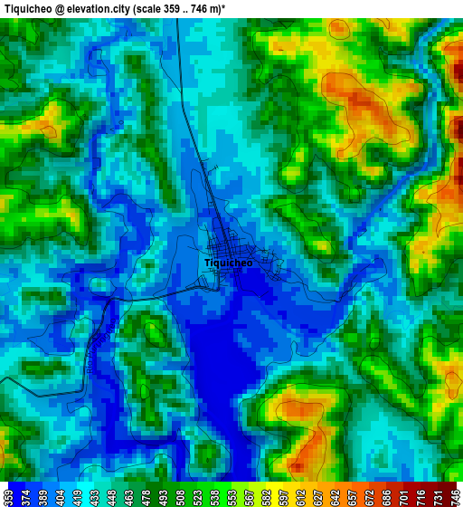
Below is the Elevation map of Tiquicheo, which displays elevation range with different colors. Scale of the first map is from 359 to 746 m (1178 to 2448 ft) with average elevation of 460.9 meters (=1512 ft) [note 1]
These maps also provides idea of topography and contour of this city, they are displayed at different zoom levels. More info about maps, scale and edge coordinates you can find below images.
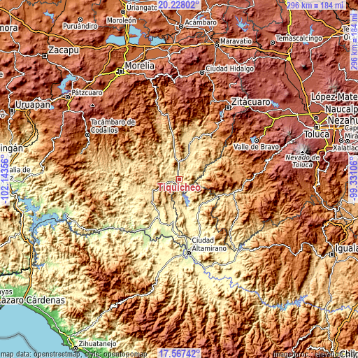
| \ | Map #1 | Topo.Map |
| Scale [m] | 359..746 m | × |
| Scale [ft] | 1178..2448 ft | × |
| Average | 460.9 m = 1512 ft | × |
| Width | 9.25 km = 5.7 mi | 295.8 km = 183.8 mi |
| Height | 9.25 km = 5.7 mi | 295.9 km = 183.9 mi |
| ↑Max Latitude | 18.94458° | 20.22802° |
| Latitude at center | 18.90301° | 18.90301° |
| ↓Min Latitude | 18.86143° | 17.56742° |
| ← Min Longitude | -100.781255° | -102.14356° |
| Longitude center | -100.73731° | -100.73731° |
| →Max Longitude | -100.693365° | -99.33106° |
Nearby cities:
Cities around Tiquicheo sort by population:
• Huetamo de Núñez elevation 304 m
34.8 km,  208°
208°
• Tuzantla 655 m
37.9 km,  28°
28°
• Villa Luvianos 1454 m
35.5 km,  87°
87°
• Villa Luvianos 1139 m
46.2 km, 87°
• Carácuaro 544 m
42.8 km,  287°
287°
• Palmar Chico 789 m
45.1 km,  120°
120°
• San Lucas 311 m
35.1 km,  188°
188°
• Benito Juárez 1129 m
46.5 km,  37°
37°
• Bejucos 539 m
35.4 km,  113°
113°
• Zacapuato 364 m
29.5 km,  152°
152°
• Purechucho 284 m
39.1 km,  204°
204°
• Paso de Núñez (Buenavista) 694 m
22 km,  267°
267°
Multilingual:
 En español:
Tiquicheo elevación 388 m.
 En France:
Tiquicheo élévation 388 m.
 Auf Deutsch:
Tiquicheo höhe über dem Meeresspiegel ist 388 m.

Sources and notes:
- [note 1] Map square and city borders are not equal. Map elevation data is calculated only from area inside that square.
- [src 1] Elevation data from geonames database provided with same terms of usage.
- [src 2] The elevation map of Tiquicheo is generated using elevation data from NASA's 3 arcsec (90m) resolution SRTM data.
- [src 3] Base (background) map © OpenStreetMap contributors tiles are generated by Geofabrik and OpenTopoMap.
Copyright & License:
This Tiquicheo Elevation Map is licensed under CC BY-SA. You may reuse any part from this page, if you give a proper credit by linking to this URL:
 More info on terms of use page.