Carácuaro elevation
Carácuaro (Michoacán), Mexico elevation is 544 meters and Carácuaro elevation in feet is 1785 ft above sea level [src 1]. Carácuaro is a populated place (feature code) with elevation that is 770 meters (2526 ft) smaller than average city elevation in Mexico.
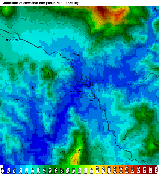
Below is the Elevation map of Carácuaro, which displays elevation range with different colors. Scale of the first map is from 507 to 1339 m (1663 to 4393 ft) with average elevation of 665.8 meters (=2184 ft) [note 1]
These maps also provides idea of topography and contour of this city, they are displayed at different zoom levels. More info about maps, scale and edge coordinates you can find below images.
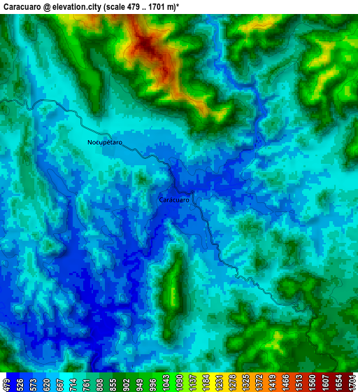
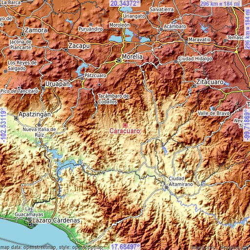
| \ | Map #1 | Map #2 | Topo.Map |
| Scale [m] | 507..1339 m | 479..1701 m | × |
| Scale [ft] | 1663..4393 ft | 1572..5581 ft | × |
| Average | 665.8 m = 2184 ft | 755.2 m = 2478 ft | × |
| Width | 9.24 km = 5.7 mi | 18.48 km = 11.5 mi | 295.6 km = 183.7 mi |
| Height | 9.24 km = 5.7 mi | 18.48 km = 11.5 mi | 295.6 km = 183.7 mi |
| ↑Max Latitude | 19.061201° | 19.102732° | 20.34372° |
| Latitude at center | 19.01966° | 19.01966° | 19.01966° |
| ↓Min Latitude | 18.978109° | 18.936547° | 17.68497° |
| ← Min Longitude | -101.168885° | -101.212831° | -102.53119° |
| Longitude center | -101.12494° | -101.12494° | -101.12494° |
| →Max Longitude | -101.080995° | -101.037049° | -99.71869° |
Nearby cities:
Cities around Carácuaro sort by population:
• Tacámbaro de Codallos elevation 1656 m
42.4 km,  304°
304°
• Puruarán 1117 m
42.6 km,  281°
281°
• Villa Madero 2188 m
44.4 km,  338°
338°
• Pedernales 1044 m
38.6 km,  290°
290°
• Tiquicheo 388 m
42.8 km,  107°
107°
• Nocupétaro 665 m
4.7 km, 304°
• La Ermita (Nueva Jerusalén) 1154 m
40.6 km, 278°
• Turicato 739 m
31.1 km, 277°
• Chupio 1179 m
38.1 km, 297°
• Paso de Núñez (Buenavista) 694 m
23.3 km,  126°
126°
• Etúcuaro 1579 m
45.5 km,  347°
347°
• San Rafael Tecario 1538 m
45.4 km, 297°
Multilingual:
 En español:
Carácuaro elevación 544 m.
 En France:
Carácuaro élévation 544 m.
 Auf Deutsch:
Carácuaro höhe über dem Meeresspiegel ist 544 m.

Sources and notes:
- [note 1] Map square and city borders are not equal. Map elevation data is calculated only from area inside that square.
- [src 1] Elevation data from geonames database provided with same terms of usage.
- [src 2] The elevation map of Carácuaro is generated using elevation data from NASA's 3 arcsec (90m) resolution SRTM data.
- [src 3] Base (background) map © OpenStreetMap contributors tiles are generated by Geofabrik and OpenTopoMap.
Copyright & License:
This Carácuaro Elevation Map is licensed under CC BY-SA. You may reuse any part from this page, if you give a proper credit by linking to this URL:
 More info on terms of use page.