Villa Luvianos elevation
Villa Luvianos (State of Mexico, Luvianos), Mexico elevation is 1454 meters and Villa Luvianos elevation in feet is 4770 ft above sea level [src 1]. Villa Luvianos is a seat of a second-order administrative division (feature code) with elevation that is 140 meters (459 ft) bigger than average city elevation in Mexico.
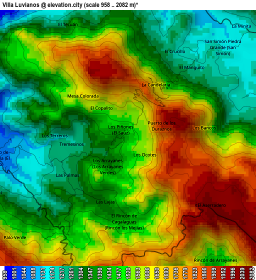
Below is the Elevation map of Villa Luvianos, which displays elevation range with different colors. Scale of the first map is from 958 to 2082 m (3143 to 6831 ft) with average elevation of 1503.9 meters (=4934 ft) [note 1]
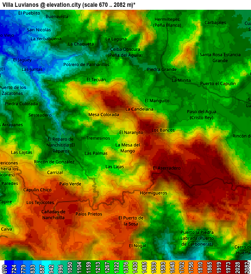
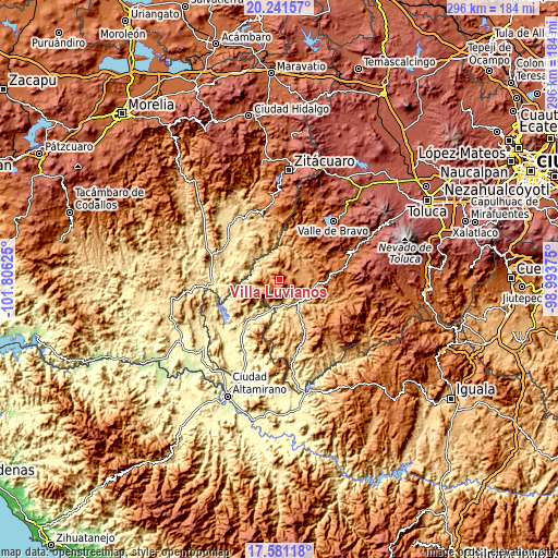
These maps also provides idea of topography and contour of this city, they are displayed at different zoom levels. More info about maps, scale and edge coordinates you can find below images.
| \ | Map #1 | Map #2 | Topo.Map |
| Scale [m] | 958..2082 m | 670..2082 m | × |
| Scale [ft] | 3143..6831 ft | 2198..6831 ft | × |
| Average | 1503.9 m = 4934 ft | 1413.9 m = 4639 ft | × |
| Width | 9.24 km = 5.7 mi | 18.49 km = 11.5 mi | 295.8 km = 183.8 mi |
| Height | 9.24 km = 5.7 mi | 18.49 km = 11.5 mi | 295.8 km = 183.8 mi |
| ↑Max Latitude | 18.958237° | 18.999793° | 20.24157° |
| Latitude at center | 18.91667° | 18.91667° | 18.91667° |
| ↓Min Latitude | 18.875093° | 18.833506° | 17.58118° |
| ← Min Longitude | -100.443945° | -100.487891° | -101.80625° |
| Longitude center | -100.4° | -100.4° | -100.4° |
| →Max Longitude | -100.356055° | -100.312109° | -98.99375° |
Nearby cities:
Cities around Villa Luvianos sort by population:
• Tejupilco de Hidalgo elevation 1334 m
26 km,  92°
92°
• Villa Luvianos 1139 m
10.7 km, 88°
• Palmar Chico 789 m
24.8 km,  172°
172°
• Zacazonapan 1361 m
23.1 km,  41°
41°
• Bejucos 539 m
15.7 km,  190°
190°
• San Pedro Tenayac 1721 m
27.5 km,  58°
58°
• Rincón de Jaimes 1348 m
24.8 km, 94°
• Otzoloapan 1380 m
24.8 km,  25°
25°
• Tenería 1781 m
32.9 km,  78°
78°
• San Miguel Ixtapan 1013 m
28.7 km,  115°
115°
• Rincón de Aguirre 1325 m
27.8 km, 93°
• Santo Tomás de los Plátanos 1393 m
33.1 km, 26°
Multilingual:
 En español:
Villa Luvianos, Luvianos elevación 1454 m.
 En France:
Villa Luvianos élévation 1454 m.
 Auf Deutsch:
Villa Luvianos höhe über dem Meeresspiegel ist 1454 m.

Sources and notes:
- [note 1] Map square and city borders are not equal. Map elevation data is calculated only from area inside that square.
- [src 1] Elevation data from geonames database provided with same terms of usage.
- [src 2] The elevation map of Villa Luvianos is generated using elevation data from NASA's 3 arcsec (90m) resolution SRTM data.
- [src 3] Base (background) map © OpenStreetMap contributors tiles are generated by Geofabrik and OpenTopoMap.
Copyright & License:
This Villa Luvianos Elevation Map is licensed under CC BY-SA. You may reuse any part from this page, if you give a proper credit by linking to this URL:
 More info on terms of use page.