San Pedro Tenayac elevation
San Pedro Tenayac (State of Mexico, Temascaltepec), Mexico elevation is 1721 meters and San Pedro Tenayac elevation in feet is 5646 ft above sea level [src 1]. San Pedro Tenayac is a populated place (feature code) with elevation that is 407 meters (1335 ft) bigger than average city elevation in Mexico.
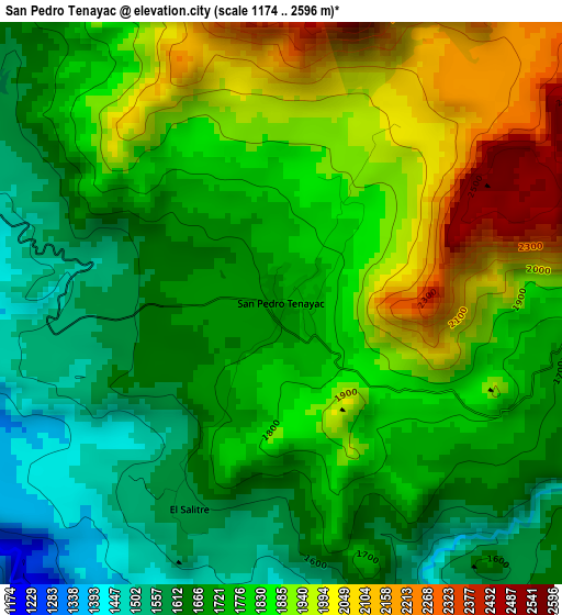
Below is the Elevation map of San Pedro Tenayac, which displays elevation range with different colors. Scale of the first map is from 1174 to 2596 m (3852 to 8517 ft) with average elevation of 1790 meters (=5873 ft) [note 1]
These maps also provides idea of topography and contour of this city, they are displayed at different zoom levels. More info about maps, scale and edge coordinates you can find below images.
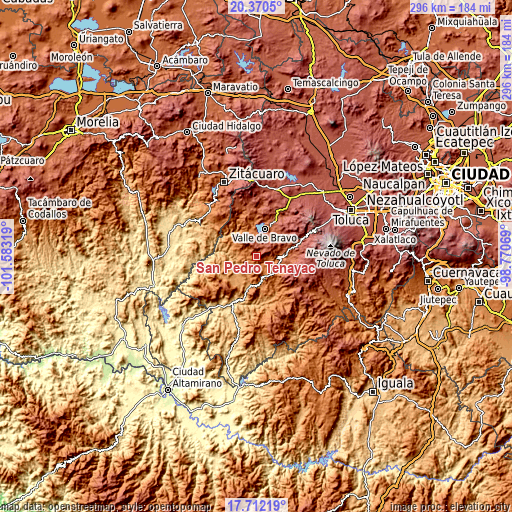
| \ | Map #1 | Topo.Map |
| Scale [m] | 1174..2596 m | × |
| Scale [ft] | 3852..8517 ft | × |
| Average | 1790 m = 5873 ft | × |
| Width | 9.24 km = 5.7 mi | 295.6 km = 183.7 mi |
| Height | 9.24 km = 5.7 mi | 295.6 km = 183.7 mi |
| ↑Max Latitude | 19.088204° | 20.3705° |
| Latitude at center | 19.04667° | 19.04667° |
| ↓Min Latitude | 19.005125° | 17.71219° |
| ← Min Longitude | -100.220885° | -101.58319° |
| Longitude center | -100.17694° | -100.17694° |
| →Max Longitude | -100.132995° | -98.77069° |
Nearby cities:
Cities around San Pedro Tenayac sort by population:
• Tejupilco de Hidalgo elevation 1334 m
16 km,  170°
170°
• Colorines 1625 m
15.3 km,  343°
343°
• Zacazonapan 1361 m
8.7 km,  289°
289°
• Temascaltepec de González 1723 m
14.1 km,  91°
91°
• Loma Bonita 1660 m
16.1 km,  345°
345°
• Rincón de Jaimes 1348 m
16.5 km,  175°
175°
• Otzoloapan 1380 m
14.8 km,  301°
301°
• San Juan Atezcapan 1859 m
13.4 km,  356°
356°
• Tenería 1781 m
12 km,  132°
132°
• Cuadrilla de Dolores 2192 m
15.3 km,  47°
47°
• La Albarrada (San Francisco la Albarrada) 2189 m
10.9 km,  77°
77°
• Casas Viejas 2053 m
13.8 km,  31°
31°
Multilingual:
 En español:
San Pedro Tenayac elevación 1721 m.
 En France:
San Pedro Tenayac élévation 1721 m.
 Auf Deutsch:
San Pedro Tenayac höhe über dem Meeresspiegel ist 1721 m.
 На русском:
San Pedro Tenayac высота над уровнем моря 1721 м
Sources and notes:
- [note 1] Map square and city borders are not equal. Map elevation data is calculated only from area inside that square.
- [src 1] Elevation data from geonames database provided with same terms of usage.
- [src 2] The elevation map of San Pedro Tenayac is generated using elevation data from NASA's 3 arcsec (90m) resolution SRTM data.
- [src 3] Base (background) map © OpenStreetMap contributors tiles are generated by Geofabrik and OpenTopoMap.
Copyright & License:
This San Pedro Tenayac Elevation Map is licensed under CC BY-SA. You may reuse any part from this page, if you give a proper credit by linking to this URL:
 More info on terms of use page.