Tzitzio elevation
Tzitzio (Michoacán), Mexico elevation is 1543 meters and Tzitzio elevation in feet is 5062 ft above sea level [src 1]. Tzitzio is a seat of a second-order administrative division (feature code) with elevation that is 229 meters (751 ft) bigger than average city elevation in Mexico.
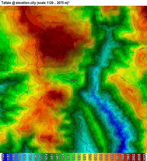
Below is the Elevation map of Tzitzio, which displays elevation range with different colors. Scale of the first map is from 1120 to 2075 m (3675 to 6808 ft) with average elevation of 1628.7 meters (=5344 ft) [note 1]
These maps also provides idea of topography and contour of this city, they are displayed at different zoom levels. More info about maps, scale and edge coordinates you can find below images.
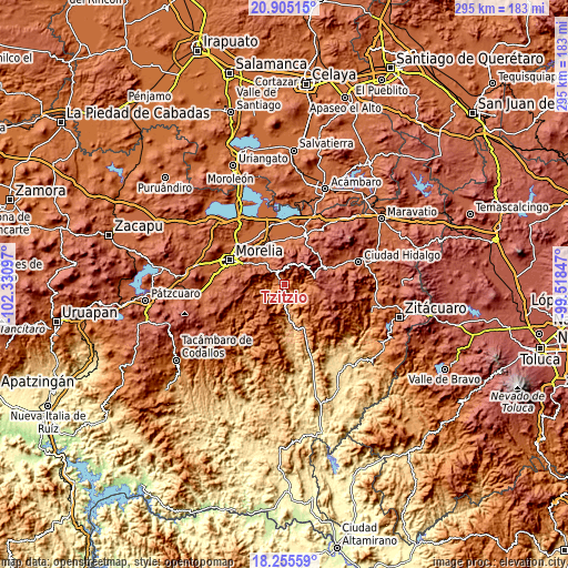
| \ | Map #1 | Topo.Map |
| Scale [m] | 1120..2075 m | × |
| Scale [ft] | 3675..6808 ft | × |
| Average | 1628.7 m = 5344 ft | × |
| Width | 9.21 km = 5.7 mi | 294.6 km = 183.1 mi |
| Height | 9.21 km = 5.7 mi | 294.6 km = 183.1 mi |
| ↑Max Latitude | 19.627217° | 20.90515° |
| Latitude at center | 19.58582° | 19.58582° |
| ↓Min Latitude | 19.544412° | 18.25559° |
| ← Min Longitude | -100.968665° | -102.33097° |
| Longitude center | -100.92472° | -100.92472° |
| →Max Longitude | -100.880775° | -99.51847° |
Nearby cities:
Cities around Tzitzio sort by population:
• Indaparapeo elevation 1930 m
22.9 km,  348°
348°
• Charo 1891 m
22.2 km,  325°
325°
• Zurumbeneo 1985 m
15.6 km,  324°
324°
• San Lucas Pío 1864 m
23.1 km,  0°
0°
• San Antonio Villalongín 2189 m
18.9 km,  107°
107°
• Huajúmbaro 2297 m
22 km,  60°
60°
• Irapeo 1973 m
18.4 km,  310°
310°
• La Goleta 1878 m
23.6 km, 316°
• Tafetán 928 m
18.7 km,  174°
174°
• Jaripeo 2062 m
19.8 km,  301°
301°
• Colonia de Guadalupe 1846 m
23.9 km, 2°
• Pueblo Viejo 2279 m
24.1 km,  28°
28°
Multilingual:
 En español:
Tzitzio elevación 1543 m.
 En France:
Tzitzio élévation 1543 m.
 Auf Deutsch:
Tzitzio höhe über dem Meeresspiegel ist 1543 m.

Sources and notes:
- [note 1] Map square and city borders are not equal. Map elevation data is calculated only from area inside that square.
- [src 1] Elevation data from geonames database provided with same terms of usage.
- [src 2] The elevation map of Tzitzio is generated using elevation data from NASA's 3 arcsec (90m) resolution SRTM data.
- [src 3] Base (background) map © OpenStreetMap contributors tiles are generated by Geofabrik and OpenTopoMap.
Copyright & License:
This Tzitzio Elevation Map is licensed under CC BY-SA. You may reuse any part from this page, if you give a proper credit by linking to this URL:
 More info on terms of use page.