Charo elevation
Charo (Michoacán), Mexico elevation is 1891 meters and Charo elevation in feet is 6204 ft above sea level [src 1]. Charo is a populated place (feature code) with elevation that is 577 meters (1893 ft) bigger than average city elevation in Mexico.
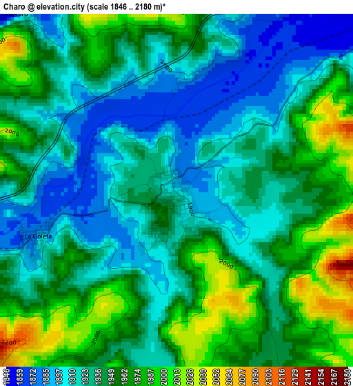
Below is the Elevation map of Charo, which displays elevation range with different colors. Scale of the first map is from 1846 to 2180 m (6056 to 7152 ft) with average elevation of 1941.2 meters (=6369 ft) [note 1]
These maps also provides idea of topography and contour of this city, they are displayed at different zoom levels. More info about maps, scale and edge coordinates you can find below images.
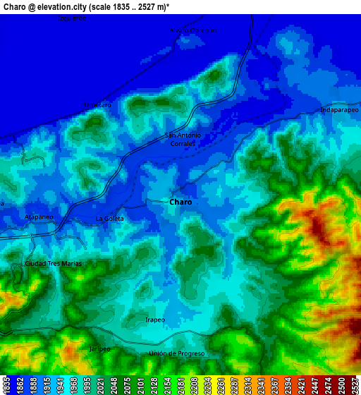
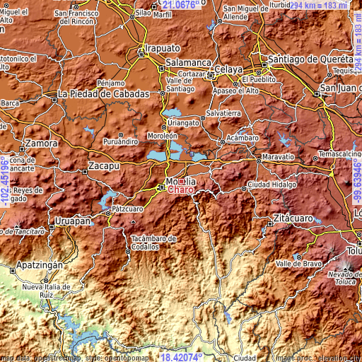
| \ | Map #1 | Map #2 | Topo.Map |
| Scale [m] | 1846..2180 m | 1835..2527 m | × |
| Scale [ft] | 6056..7152 ft | 6020..8291 ft | × |
| Average | 1941.2 m = 6369 ft | 1981.5 m = 6501 ft | × |
| Width | 9.2 km = 5.7 mi | 18.4 km = 11.4 mi | 294.3 km = 182.9 mi |
| Height | 9.2 km = 5.7 mi | 18.4 km = 11.4 mi | 294.3 km = 182.9 mi |
| ↑Max Latitude | 19.791015° | 19.832359° | 21.0676° |
| Latitude at center | 19.74966° | 19.74966° | 19.74966° |
| ↓Min Latitude | 19.708294° | 19.666918° | 18.42074° |
| ← Min Longitude | -101.089655° | -101.133601° | -102.45196° |
| Longitude center | -101.04571° | -101.04571° | -101.04571° |
| →Max Longitude | -101.001765° | -100.957819° | -99.63946° |
Nearby cities:
Cities around Charo sort by population:
• Álvaro Obregón elevation 1881 m
7.9 km,  4°
4°
• Fraccionamiento Misión del Valle 1995 m
8.1 km,  282°
282°
• Indaparapeo 1930 m
9.1 km,  62°
62°
• Zurumbeneo 1985 m
6.6 km,  146°
146°
• Uruétaro 1851 m
6.3 km,  315°
315°
• Atapaneo 1896 m
7.4 km,  260°
260°
• Irapeo 1973 m
6.4 km,  191°
191°
• La Goleta 1878 m
3.9 km,  252°
252°
• Jaripeo 2062 m
8.8 km,  208°
208°
• Fraccionamiento Laureles Eréndira 1861 m
9.2 km,  285°
285°
• Colonia Miguel Hidalgo 1847 m
7.1 km,  304°
304°
• El Cuitzillo Grande 1858 m
8.2 km, 294°
Multilingual:
 En español:
Charo elevación 1891 m.
 En France:
Charo élévation 1891 m.


Sources and notes:
- [note 1] Map square and city borders are not equal. Map elevation data is calculated only from area inside that square.
- [src 1] Elevation data from geonames database provided with same terms of usage.
- [src 2] The elevation map of Charo is generated using elevation data from NASA's 3 arcsec (90m) resolution SRTM data.
- [src 3] Base (background) map © OpenStreetMap contributors tiles are generated by Geofabrik and OpenTopoMap.
Copyright & License:
This Charo Elevation Map is licensed under CC BY-SA. You may reuse any part from this page, if you give a proper credit by linking to this URL:
 More info on terms of use page.