Valle de Juárez elevation
Valle de Juárez (Jalisco), Mexico elevation is 1976 meters and Valle de Juárez elevation in feet is 6483 ft above sea level [src 1]. Valle de Juárez is a seat of a second-order administrative division (feature code) with elevation that is 662 meters (2172 ft) bigger than average city elevation in Mexico.
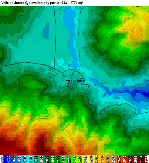
Below is the Elevation map of Valle de Juárez, which displays elevation range with different colors. Scale of the first map is from 1743 to 2771 m (5719 to 9091 ft) with average elevation of 2128.4 meters (=6983 ft) [note 1]
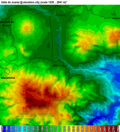
These maps also provides idea of topography and contour of this city, they are displayed at different zoom levels. More info about maps, scale and edge coordinates you can find below images.
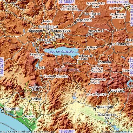
| \ | Map #1 | Map #2 | Topo.Map |
| Scale [m] | 1743..2771 m | 1538..2841 m | × |
| Scale [ft] | 5719..9091 ft | 5046..9321 ft | × |
| Average | 2128.4 m = 6983 ft | 2109.3 m = 6920 ft | × |
| Width | 9.19 km = 5.7 mi | 18.37 km = 11.4 mi | 294 km = 182.7 mi |
| Height | 9.19 km = 5.7 mi | 18.37 km = 11.4 mi | 294 km = 182.7 mi |
| ↑Max Latitude | 19.973787° | 20.015084° | 21.24886° |
| Latitude at center | 19.93248° | 19.93248° | 19.93248° |
| ↓Min Latitude | 19.891162° | 19.849833° | 18.60504° |
| ← Min Longitude | -102.987525° | -103.031471° | -104.34983° |
| Longitude center | -102.94358° | -102.94358° | -102.94358° |
| →Max Longitude | -102.899635° | -102.855689° | -101.53733° |
Nearby cities:
Cities around Valle de Juárez sort by population:
• Jiquílpan de Juárez elevation 1552 m
24.4 km,  73°
73°
• Tizapán el Alto 1542 m
27.5 km,  337°
337°
• San José de Gracia 2001 m
10.4 km,  307°
307°
• Mazamitla 2253 m
8.2 km,  257°
257°
• Cojumatlán de Régules 1549 m
22.8 km,  24°
24°
• Villa Emiliano Zapata 1544 m
26.5 km,  349°
349°
• La Manzanilla de la Paz 2057 m
23.5 km,  290°
290°
• Quitupan 1652 m
7.4 km,  94°
94°
• Lázaro Cárdenas 1628 m
12.6 km,  112°
112°
• Fraccionamiento Colinas Universidad 1655 m
23.6 km, 66°
• La Garita 1192 m
25.6 km,  226°
226°
• Ojo de Rana 2169 m
13.9 km, 22°
Multilingual:
 En español:
Valle de Juárez elevación 1976 m.
 En France:
Valle de Juárez élévation 1976 m.
 Auf Deutsch:
Valle de Juárez höhe über dem Meeresspiegel ist 1976 m.

Sources and notes:
- [note 1] Map square and city borders are not equal. Map elevation data is calculated only from area inside that square.
- [src 1] Elevation data from geonames database provided with same terms of usage.
- [src 2] The elevation map of Valle de Juárez is generated using elevation data from NASA's 3 arcsec (90m) resolution SRTM data.
- [src 3] Base (background) map © OpenStreetMap contributors tiles are generated by Geofabrik and OpenTopoMap.
Copyright & License:
This Valle de Juárez Elevation Map is licensed under CC BY-SA. You may reuse any part from this page, if you give a proper credit by linking to this URL:
 More info on terms of use page.