Jiquílpan de Juárez elevation
Jiquílpan de Juárez (Michoacán, Jiquilpan), Mexico elevation is 1552 meters and Jiquílpan de Juárez elevation in feet is 5092 ft above sea level [src 1]. Jiquílpan de Juárez is a seat of a second-order administrative division (feature code) with elevation that is 238 meters (781 ft) bigger than average city elevation in Mexico.
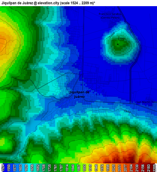
Below is the Elevation map of Jiquílpan de Juárez, which displays elevation range with different colors. Scale of the first map is from 1524 to 2209 m (5000 to 7247 ft) with average elevation of 1682.2 meters (=5519 ft) [note 1]
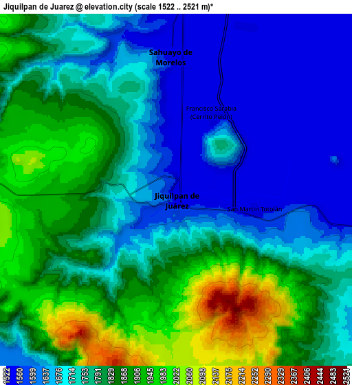
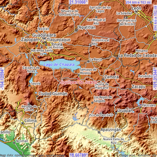
These maps also provides idea of topography and contour of this city, they are displayed at different zoom levels. More info about maps, scale and edge coordinates you can find below images.
| \ | Map #1 | Map #2 | Topo.Map |
| Scale [m] | 1524..2209 m | 1522..2521 m | × |
| Scale [ft] | 5000..7247 ft | 4993..8271 ft | × |
| Average | 1682.2 m = 5519 ft | 1769.2 m = 5804 ft | × |
| Width | 9.18 km = 5.7 mi | 18.37 km = 11.4 mi | 293.8 km = 182.6 mi |
| Height | 9.18 km = 5.7 mi | 18.37 km = 11.4 mi | 293.9 km = 182.6 mi |
| ↑Max Latitude | 20.036111° | 20.077391° | 21.31066° |
| Latitude at center | 19.99482° | 19.99482° | 19.99482° |
| ↓Min Latitude | 19.953518° | 19.912205° | 18.66789° |
| ← Min Longitude | -102.763635° | -102.807581° | -104.12594° |
| Longitude center | -102.71969° | -102.71969° | -102.71969° |
| →Max Longitude | -102.675745° | -102.631799° | -101.31344° |
Nearby cities:
Cities around Jiquílpan de Juárez sort by population:
• Sahuayo de Morelos elevation 1536 m
7.1 km,  3°
3°
• Venustiano Carranza 1531 m
15.1 km,  27°
27°
• La Palma 1554 m
17.5 km,  346°
346°
• Emiliano Zapata 1543 m
10.9 km,  90°
90°
• Villamar 1536 m
13.2 km,  77°
77°
• Fraccionamiento San Miguel 1527 m
9.2 km,  22°
22°
• El Platanal 1530 m
16.6 km,  63°
63°
• Francisco Sarabia (Cerrito Pelón) 1531 m
4.4 km, 25°
• Los Remedios 1583 m
4.6 km,  113°
113°
• San Martín Totolán 1547 m
4.3 km,  104°
104°
• Lázaro Cárdenas 1628 m
16.6 km,  225°
225°
• Fraccionamiento Colinas Universidad 1655 m
3.2 km,  325°
325°
Multilingual:
 En español:
Jiquílpan de Juárez elevación 1552 m.
 En France:
Jiquílpan de Juárez élévation 1552 m.
 Auf Deutsch:
Jiquílpan de Juárez höhe über dem Meeresspiegel ist 1552 m.
 На русском:
Jiquílpan de Juárez высота над уровнем моря 1552 м
Sources and notes:
- [note 1] Map square and city borders are not equal. Map elevation data is calculated only from area inside that square.
- [src 1] Elevation data from geonames database provided with same terms of usage.
- [src 2] The elevation map of Jiquílpan de Juárez is generated using elevation data from NASA's 3 arcsec (90m) resolution SRTM data.
- [src 3] Base (background) map © OpenStreetMap contributors tiles are generated by Geofabrik and OpenTopoMap.
Copyright & License:
This Jiquílpan de Juárez Elevation Map is licensed under CC BY-SA. You may reuse any part from this page, if you give a proper credit by linking to this URL:
 More info on terms of use page.