La Garita elevation
La Garita (Jalisco, Tamazula de Gordiano), Mexico elevation is 1192 meters and La Garita elevation in feet is 3911 ft above sea level [src 1]. La Garita is a populated place (feature code) with elevation that is 122 meters (400 ft) smaller than average city elevation in Mexico.
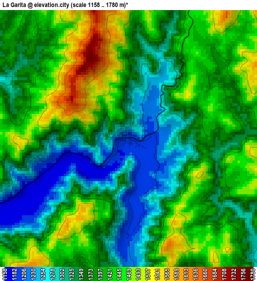
Below is the Elevation map of La Garita, which displays elevation range with different colors. Scale of the first map is from 1158 to 1780 m (3799 to 5840 ft) with average elevation of 1384 meters (=4541 ft) [note 1]
These maps also provides idea of topography and contour of this city, they are displayed at different zoom levels. More info about maps, scale and edge coordinates you can find below images.
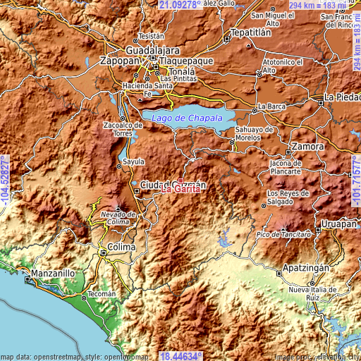
| \ | Map #1 | Topo.Map |
| Scale [m] | 1158..1780 m | × |
| Scale [ft] | 3799..5840 ft | × |
| Average | 1384 m = 4541 ft | × |
| Width | 9.2 km = 5.7 mi | 294.3 km = 182.9 mi |
| Height | 9.2 km = 5.7 mi | 294.3 km = 182.9 mi |
| ↑Max Latitude | 19.816398° | 21.09278° |
| Latitude at center | 19.77505° | 19.77505° |
| ↓Min Latitude | 19.733691° | 18.44634° |
| ← Min Longitude | -103.165965° | -104.52827° |
| Longitude center | -103.12202° | -103.12202° |
| →Max Longitude | -103.078075° | -101.71577° |
Nearby cities:
Cities around La Garita sort by population:
• Tamazula de Gordiano elevation 1140 m
17.2 km,  232°
232°
• San José de Gracia 2001 m
26.1 km,  23°
23°
• Mazamitla 2253 m
19 km,  34°
34°
• Concepción de Buenos Aires 2135 m
26.8 km,  327°
327°
• Valle de Juárez 1976 m
25.6 km,  46°
46°
• Vista Hermosa 1177 m
24.5 km,  248°
248°
• El Rincón 1250 m
31.7 km, 247°
• La Manzanilla de la Paz 2057 m
25.8 km,  352°
352°
• Quitupan 1652 m
31.1 km,  57°
57°
• Soyatlán de Afuera 1133 m
19.3 km,  240°
240°
• San Vicente 1153 m
19.4 km,  224°
224°
• Santa María del Oro 956 m
30.5 km,  133°
133°
Multilingual:
 En español:
La Garita elevación 1192 m.
 En France:
La Garita élévation 1192 m.
 Auf Deutsch:
La Garita höhe über dem Meeresspiegel ist 1192 m.

Sources and notes:
- [note 1] Map square and city borders are not equal. Map elevation data is calculated only from area inside that square.
- [src 1] Elevation data from geonames database provided with same terms of usage.
- [src 2] The elevation map of La Garita is generated using elevation data from NASA's 3 arcsec (90m) resolution SRTM data.
- [src 3] Base (background) map © OpenStreetMap contributors tiles are generated by Geofabrik and OpenTopoMap.
Copyright & License:
This La Garita Elevation Map is licensed under CC BY-SA. You may reuse any part from this page, if you give a proper credit by linking to this URL:
 More info on terms of use page.