Venado elevation
Venado (San Luis Potosí), Mexico elevation is 1799 meters and Venado elevation in feet is 5902 ft above sea level [src 1]. Venado is a seat of a second-order administrative division (feature code) with elevation that is 485 meters (1591 ft) bigger than average city elevation in Mexico.
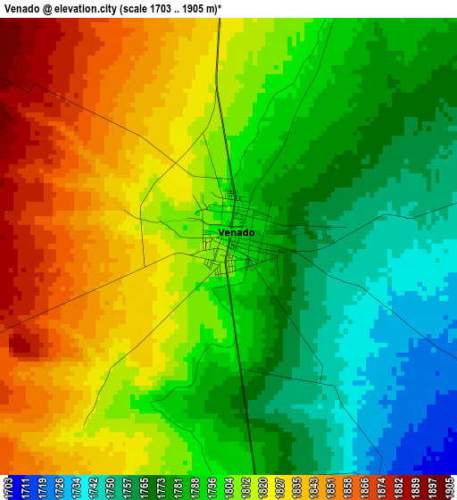
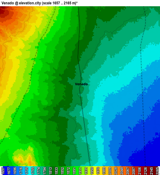
Below is the Elevation map of Venado, which displays elevation range with different colors. Scale of the first map is from 1703 to 1905 m (5587 to 6250 ft) with average elevation of 1801.5 meters (=5910 ft) [note 1]
These maps also provides idea of topography and contour of this city, they are displayed at different zoom levels. More info about maps, scale and edge coordinates you can find below images.
| \ | Map #1 | Map #2 | Topo.Map |
| Scale [m] | 1703..1905 m | 1657..2165 m | × |
| Scale [ft] | 5587..6250 ft | 5436..7103 ft | × |
| Average | 1801.5 m = 5910 ft | 1822.5 m = 5979 ft | × |
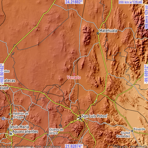
| Width | 9 km = 5.6 mi | 18 km = 11.2 mi | 288 km = 179 mi |
| Height | 9 km = 5.6 mi | 18 km = 11.2 mi | 288 km = 179 mi |
| ↑Max Latitude | 22.970437° | 23.010891° | 24.21882° |
| Latitude at center | 22.92997° | 22.92997° | 22.92997° |
| ↓Min Latitude | 22.889491° | 22.849° | 21.62874° |
| ← Min Longitude | -101.139315° | -101.183261° | -102.50162° |
| Longitude center | -101.09537° | -101.09537° | -101.09537° |
| →Max Longitude | -101.051425° | -101.007479° | -99.68912° |
Nearby cities:
Cities around Venado sort by population:
• Charcas elevation 2017 m
22.3 km,  355°
355°
• Villa de Arista 1616 m
40.8 km,  141°
141°
• Moctezuma 1734 m
20.3 km,  176°
176°
• Ahualulco del Sonido Trece 1854 m
59.4 km,  187°
187°
• Santiago 2142 m
64.7 km,  215°
215°
• Derramaderos 1656 m
43.4 km,  157°
157°
• Puerto de Providencia 1867 m
62.9 km, 177°
• Cerrito de Zavala 1692 m
45.4 km, 164°
• Norias del Refugio 1321 m
64.5 km,  81°
81°
• Bocas 1723 m
46.4 km,  170°
170°
• Palmar Primero 1846 m
62.2 km, 180°
• Villa de Guadalupe 1630 m
60.3 km,  35°
35°
Multilingual:
 En español:
Venado elevación 1799 m.
 En France:
Venado élévation 1799 m.


Sources and notes:
- [note 1] Map square and city borders are not equal. Map elevation data is calculated only from area inside that square.
- [src 1] Elevation data from geonames database provided with same terms of usage.
- [src 2] The elevation map of Venado is generated using elevation data from NASA's 3 arcsec (90m) resolution SRTM data.
- [src 3] Base (background) map © OpenStreetMap contributors tiles are generated by Geofabrik and OpenTopoMap.
Copyright & License:
This Venado Elevation Map is licensed under CC BY-SA. You may reuse any part from this page, if you give a proper credit by linking to this URL:
 More info on terms of use page.