Ahualulco del Sonido Trece elevation
Ahualulco del Sonido Trece (San Luis Potosí, Ahualulco), Mexico elevation is 1854 meters and Ahualulco del Sonido Trece elevation in feet is 6083 ft above sea level [src 1]. Ahualulco del Sonido Trece is a seat of a second-order administrative division (feature code) with elevation that is 540 meters (1772 ft) bigger than average city elevation in Mexico.
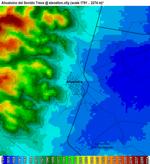
Below is the Elevation map of Ahualulco del Sonido Trece, which displays elevation range with different colors. Scale of the first map is from 1791 to 2274 m (5876 to 7461 ft) with average elevation of 1898.6 meters (=6229 ft) [note 1]
These maps also provides idea of topography and contour of this city, they are displayed at different zoom levels. More info about maps, scale and edge coordinates you can find below images.
| \ | Map #1 | Map #2 | Topo.Map |
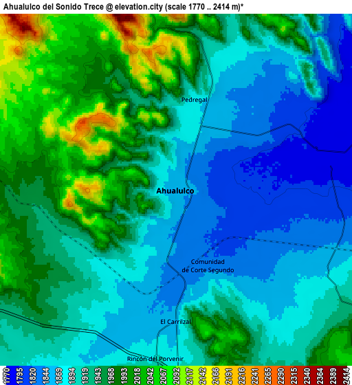
| Scale [m] | 1791..2274 m | 1770..2414 m | × |
| Scale [ft] | 5876..7461 ft | 5807..7920 ft | × |
| Average | 1898.6 m = 6229 ft | 1928.8 m = 6328 ft | × |
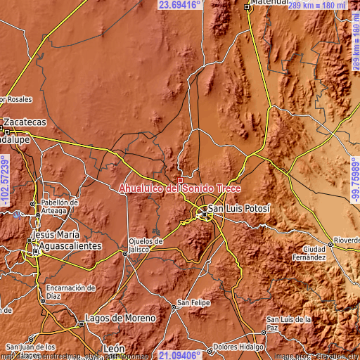
| Width | 9.04 km = 5.6 mi | 18.07 km = 11.2 mi | 289.1 km = 179.6 mi |
| Height | 9.04 km = 5.6 mi | 18.07 km = 11.2 mi | 289.1 km = 179.6 mi |
| ↑Max Latitude | 22.440813° | 22.481425° | 23.69416° |
| Latitude at center | 22.40019° | 22.40019° | 22.40019° |
| ↓Min Latitude | 22.359555° | 22.318907° | 21.09406° |
| ← Min Longitude | -101.210085° | -101.254031° | -102.57239° |
| Longitude center | -101.16614° | -101.16614° | -101.16614° |
| →Max Longitude | -101.122195° | -101.078249° | -99.75989° |
Nearby cities:
Cities around Ahualulco del Sonido Trece sort by population:
• Suspiro Picacho elevation 1981 m
22.6 km,  158°
158°
• Mexquitic de Carmona 2028 m
15.9 km, 159°
• Estanzuela 1864 m
21.9 km,  131°
131°
• Paso Bonito 1913 m
12.9 km,  229°
229°
• Puerto de Providencia 1867 m
11 km,  110°
110°
• Rincón del Porvenir 1893 m
8.6 km,  187°
187°
• Cerrito de Jaral 1969 m
22.3 km,  151°
151°
• Agua Señora 1910 m
22.1 km,  144°
144°
• El Peñasco 1829 m
23.7 km, 110°
• El Carrizal 1858 m
6.5 km,  181°
181°
• Bocas 1723 m
19.8 km,  48°
48°
• Palmar Primero 1846 m
7.7 km,  115°
115°
Multilingual:
 En español:
Ahualulco del Sonido Trece elevación 1854 m.
 En France:
Ahualulco del Sonido Trece élévation 1854 m.
 Auf Deutsch:
Ahualulco del Sonido Trece höhe über dem Meeresspiegel ist 1854 m.
 На русском:
Ahualulco del Sonido Trece высота над уровнем моря 1854 м
Sources and notes:
- [note 1] Map square and city borders are not equal. Map elevation data is calculated only from area inside that square.
- [src 1] Elevation data from geonames database provided with same terms of usage.
- [src 2] The elevation map of Ahualulco del Sonido Trece is generated using elevation data from NASA's 3 arcsec (90m) resolution SRTM data.
- [src 3] Base (background) map © OpenStreetMap contributors tiles are generated by Geofabrik and OpenTopoMap.
Copyright & License:
This Ahualulco del Sonido Trece Elevation Map is licensed under CC BY-SA. You may reuse any part from this page, if you give a proper credit by linking to this URL:
 More info on terms of use page.