Charcas elevation
Charcas (San Luis Potosí), Mexico elevation is 2017 meters and Charcas elevation in feet is 6617 ft above sea level [src 1]. Charcas is a seat of a second-order administrative division (feature code) with elevation that is 703 meters (2306 ft) bigger than average city elevation in Mexico.
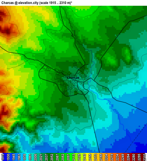
Below is the Elevation map of Charcas, which displays elevation range with different colors. Scale of the first map is from 1915 to 2310 m (6283 to 7579 ft) with average elevation of 2051 meters (=6729 ft) [note 1]
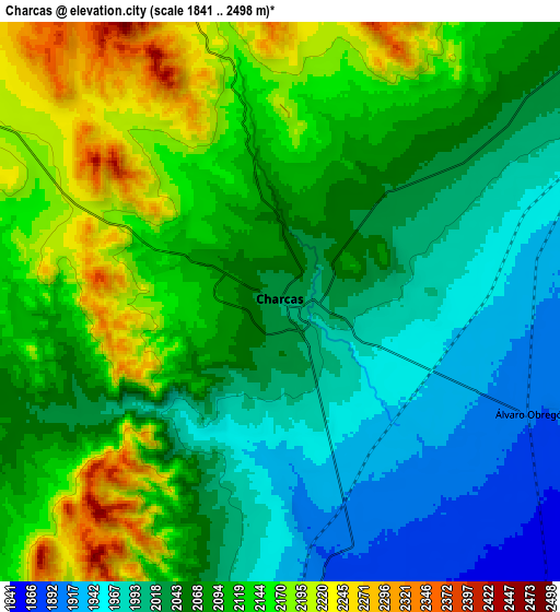
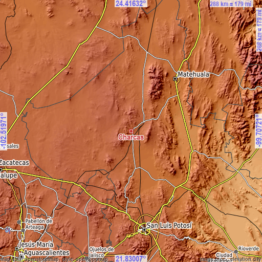
These maps also provides idea of topography and contour of this city, they are displayed at different zoom levels. More info about maps, scale and edge coordinates you can find below images.
| \ | Map #1 | Map #2 | Topo.Map |
| Scale [m] | 1915..2310 m | 1841..2498 m | × |
| Scale [ft] | 6283..7579 ft | 6040..8196 ft | × |
| Average | 2051 m = 6729 ft | 2077.1 m = 6815 ft | × |
| Width | 8.99 km = 5.6 mi | 17.97 km = 11.2 mi | 287.6 km = 178.7 mi |
| Height | 8.99 km = 5.6 mi | 17.97 km = 11.2 mi | 287.6 km = 178.7 mi |
| ↑Max Latitude | 23.169837° | 23.210232° | 24.41632° |
| Latitude at center | 23.12943° | 23.12943° | 23.12943° |
| ↓Min Latitude | 23.089011° | 23.04858° | 21.83007° |
| ← Min Longitude | -101.157405° | -101.201351° | -102.51971° |
| Longitude center | -101.11346° | -101.11346° | -101.11346° |
| →Max Longitude | -101.069515° | -101.025569° | -99.70721° |
Nearby cities:
Cities around Charcas sort by population:
• Villa de Arista elevation 1616 m
60.6 km,  153°
153°
• Venado 1799 m
22.3 km,  175°
175°
• Moctezuma 1734 m
42.5 km, 175°
• La Herradura 2144 m
65.6 km,  260°
260°
• Entronque de Matehuala (El Huizache) 1420 m
70.7 km,  108°
108°
• Derramaderos 1656 m
64.9 km,  163°
163°
• Real de Catorce 2678 m
66.5 km,  20°
20°
• Cerrito de Zavala 1692 m
67.4 km,  168°
168°
• Norias del Refugio 1321 m
66.9 km,  101°
101°
• Bocas 1723 m
68.6 km, 172°
• Villa de Guadalupe 1630 m
45.4 km,  53°
53°
• Santo Domingo 1972 m
67.3 km,  289°
289°
Multilingual:
 En español:
Charcas elevación 2017 m.
 En France:
Charcas élévation 2017 m.
 Auf Deutsch:
Charcas höhe über dem Meeresspiegel ist 2017 m.

Sources and notes:
- [note 1] Map square and city borders are not equal. Map elevation data is calculated only from area inside that square.
- [src 1] Elevation data from geonames database provided with same terms of usage.
- [src 2] The elevation map of Charcas is generated using elevation data from NASA's 3 arcsec (90m) resolution SRTM data.
- [src 3] Base (background) map © OpenStreetMap contributors tiles are generated by Geofabrik and OpenTopoMap.
Copyright & License:
This Charcas Elevation Map is licensed under CC BY-SA. You may reuse any part from this page, if you give a proper credit by linking to this URL:
 More info on terms of use page.