Santiago elevation
Santiago (Zacatecas, Pinos), Mexico elevation is 2142 meters and Santiago elevation in feet is 7028 ft above sea level [src 1]. Santiago is a populated place (feature code) with elevation that is 828 meters (2717 ft) bigger than average city elevation in Mexico.
Below is the Elevation map of Santiago, which displays elevation range with different colors. Scale of the first map is from 2081 to 2351 m (6827 to 7713 ft) with average elevation of 2163.6 meters (=7098 ft) [note 1]
These maps also provides idea of topography and contour of this city, they are displayed at different zoom levels. More info about maps, scale and edge coordinates you can find below images.
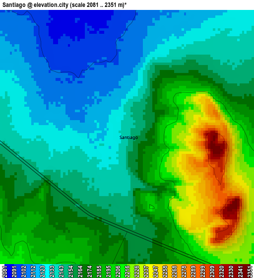
| \ | Map #1 | Topo.Map |
| Scale [m] | 2081..2351 m | × |
| Scale [ft] | 6827..7713 ft | × |
| Average | 2163.6 m = 7098 ft | × |
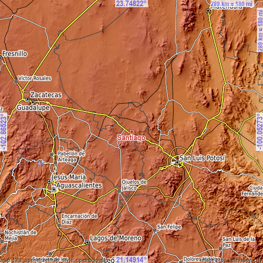
| Width | 9.03 km = 5.6 mi | 289 km = 179.6 mi |
| Height | 9.03 km = 5.6 mi | 289 km = 179.6 mi |
| ↑Max Latitude | 22.495377° | 23.74822° |
| Latitude at center | 22.45477° | 22.45477° |
| ↓Min Latitude | 22.414151° | 21.14914° |
| ← Min Longitude | -101.502925° | -102.86523° |
| Longitude center | -101.45898° | -101.45898° |
| →Max Longitude | -101.415035° | -100.05273° |
Nearby cities:
Cities around Santiago sort by population:
• Pinos elevation 2453 m
21.4 km,  214°
214°
• Villa Hidalgo 2165 m
28.3 km,  247°
247°
• Ahualulco del Sonido Trece 1854 m
30.7 km,  101°
101°
• La Victoria 2308 m
28.1 km,  218°
218°
• Estancia de Guadalupe 2290 m
28.1 km,  226°
226°
• El Refugio 2119 m
32.4 km, 253°
• La Ballena 2270 m
25.6 km,  270°
270°
• Paso Bonito 1913 m
24.9 km,  125°
125°
• Rincón del Porvenir 1893 m
32.5 km,  116°
116°
• La Pendencia 2193 m
12.2 km,  261°
261°
• El Carrizal 1858 m
32.5 km,  112°
112°
• Santa Ana 2204 m
7.2 km,  192°
192°
Multilingual:
 En español:
Santiago elevación 2142 m.
 En France:
Santiago élévation 2142 m.
 Auf Deutsch:
Santiago höhe über dem Meeresspiegel ist 2142 m.

Sources and notes:
- [note 1] Map square and city borders are not equal. Map elevation data is calculated only from area inside that square.
- [src 1] Elevation data from geonames database provided with same terms of usage.
- [src 2] The elevation map of Santiago is generated using elevation data from NASA's 3 arcsec (90m) resolution SRTM data.
- [src 3] Base (background) map © OpenStreetMap contributors tiles are generated by Geofabrik and OpenTopoMap.
Copyright & License:
This Santiago Elevation Map is licensed under CC BY-SA. You may reuse any part from this page, if you give a proper credit by linking to this URL:
 More info on terms of use page.