San Andrés de los Gama elevation
San Andrés de los Gama (State of Mexico, Temascaltepec), Mexico elevation is 2090 meters and San Andrés de los Gama elevation in feet is 6857 ft above sea level [src 1]. San Andrés de los Gama is a populated place (feature code) with elevation that is 776 meters (2546 ft) bigger than average city elevation in Mexico.
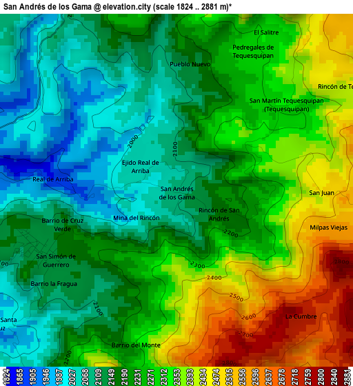
Below is the Elevation map of San Andrés de los Gama, which displays elevation range with different colors. Scale of the first map is from 1824 to 2881 m (5984 to 9452 ft) with average elevation of 2244.6 meters (=7364 ft) [note 1]
These maps also provides idea of topography and contour of this city, they are displayed at different zoom levels. More info about maps, scale and edge coordinates you can find below images.
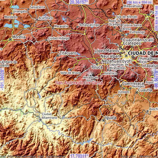
| \ | Map #1 | Topo.Map |
| Scale [m] | 1824..2881 m | × |
| Scale [ft] | 5984..9452 ft | × |
| Average | 2244.6 m = 7364 ft | × |
| Width | 9.24 km = 5.7 mi | 295.6 km = 183.7 mi |
| Height | 9.24 km = 5.7 mi | 295.6 km = 183.7 mi |
| ↑Max Latitude | 19.079196° | 20.36157° |
| Latitude at center | 19.03766° | 19.03766° |
| ↓Min Latitude | 18.996113° | 17.70311° |
| ← Min Longitude | -100.017975° | -101.38028° |
| Longitude center | -99.97403° | -99.97403° |
| →Max Longitude | -99.930085° | -98.56778° |
Nearby cities:
Cities around San Andrés de los Gama sort by population:
• Texcaltitlán elevation 2415 m
12.5 km,  162°
162°
• Temascaltepec de González 1723 m
7.2 km,  275°
275°
• San Mateo Almomoloha 2598 m
12.7 km,  18°
18°
• San Lucas del Pulque 2169 m
9.1 km,  321°
321°
• San Agustín 2380 m
11.2 km, 160°
• Texcapilla 2900 m
13.1 km,  141°
141°
• Los Saucos 2549 m
14.4 km,  349°
349°
• Tenería 1781 m
14.4 km,  240°
240°
• San Miguel Oxtotilpan 2743 m
14.4 km,  34°
34°
• La Albarrada (San Francisco la Albarrada) 2189 m
11.1 km,  287°
287°
• San Martín Tequesquipan (Tequesquipan) 2352 m
3.7 km,  51°
51°
• San Simón de Guerrero 2144 m
3.8 km, 244°
Multilingual:
 En español:
San Andrés de los Gama elevación 2090 m.
 En France:
San Andrés de los Gama élévation 2090 m.
 Auf Deutsch:
San Andrés de los Gama höhe über dem Meeresspiegel ist 2090 m.
 На русском:
San Andrés de los Gama высота над уровнем моря 2090 м
Sources and notes:
- [note 1] Map square and city borders are not equal. Map elevation data is calculated only from area inside that square.
- [src 1] Elevation data from geonames database provided with same terms of usage.
- [src 2] The elevation map of San Andrés de los Gama is generated using elevation data from NASA's 3 arcsec (90m) resolution SRTM data.
- [src 3] Base (background) map © OpenStreetMap contributors tiles are generated by Geofabrik and OpenTopoMap.
Copyright & License:
This San Andrés de los Gama Elevation Map is licensed under CC BY-SA. You may reuse any part from this page, if you give a proper credit by linking to this URL:
 More info on terms of use page.