Texcaltitlán elevation
Texcaltitlán (State of Mexico), Mexico elevation is 2415 meters and Texcaltitlán elevation in feet is 7923 ft above sea level [src 1]. Texcaltitlán is a seat of a second-order administrative division (feature code) with elevation that is 1101 meters (3612 ft) bigger than average city elevation in Mexico.
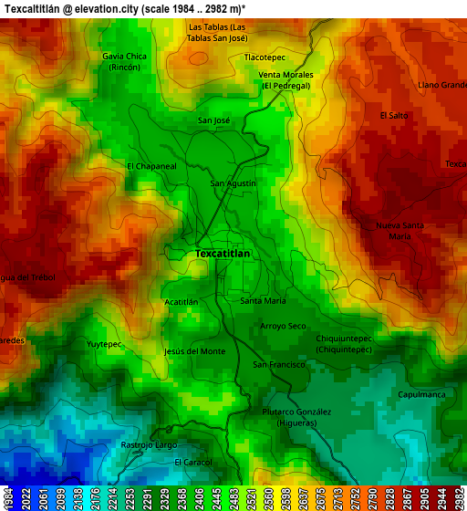
Below is the Elevation map of Texcaltitlán, which displays elevation range with different colors. Scale of the first map is from 1984 to 2982 m (6509 to 9783 ft) with average elevation of 2534.9 meters (=8317 ft) [note 1]
These maps also provides idea of topography and contour of this city, they are displayed at different zoom levels. More info about maps, scale and edge coordinates you can find below images.
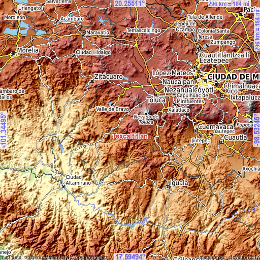
| \ | Map #1 | Topo.Map |
| Scale [m] | 1984..2982 m | × |
| Scale [ft] | 6509..9783 ft | × |
| Average | 2534.9 m = 8317 ft | × |
| Width | 9.24 km = 5.7 mi | 295.8 km = 183.8 mi |
| Height | 9.24 km = 5.7 mi | 295.8 km = 183.8 mi |
| ↑Max Latitude | 18.971883° | 20.25511° |
| Latitude at center | 18.93032° | 18.93032° |
| ↓Min Latitude | 18.888746° | 17.59494° |
| ← Min Longitude | -99.982645° | -101.34495° |
| Longitude center | -99.9387° | -99.9387° |
| →Max Longitude | -99.894755° | -98.53245° |
Nearby cities:
Cities around Texcaltitlán sort by population:
• Sultepec elevation 2314 m
8.5 km,  199°
199°
• Almoloya de Alquisiras 1968 m
8.6 km,  147°
147°
• Santa Cruz 1919 m
11.8 km, 203°
• San Andrés Tepetitlán 2269 m
4.1 km, 150°
• San Andrés Ocotepec 1586 m
11.7 km,  255°
255°
• San Agustín 2380 m
1.3 km,  358°
358°
• Texcapilla 2900 m
4.9 km,  69°
69°
• San Andrés de los Gama 2090 m
12.5 km,  342°
342°
• Chiltepec de Hidalgo 2400 m
11.1 km,  100°
100°
• San Martín Tequesquipan (Tequesquipan) 2352 m
14.2 km, 356°
• Capula 2366 m
7.1 km, 199°
• San Simón de Guerrero 2144 m
12.5 km,  325°
325°
Multilingual:
 En español:
Texcaltitlán elevación 2415 m.
 En France:
Texcaltitlán élévation 2415 m.
 Auf Deutsch:
Texcaltitlán höhe über dem Meeresspiegel ist 2415 m.

Sources and notes:
- [note 1] Map square and city borders are not equal. Map elevation data is calculated only from area inside that square.
- [src 1] Elevation data from geonames database provided with same terms of usage.
- [src 2] The elevation map of Texcaltitlán is generated using elevation data from NASA's 3 arcsec (90m) resolution SRTM data.
- [src 3] Base (background) map © OpenStreetMap contributors tiles are generated by Geofabrik and OpenTopoMap.
Copyright & License:
This Texcaltitlán Elevation Map is licensed under CC BY-SA. You may reuse any part from this page, if you give a proper credit by linking to this URL:
 More info on terms of use page.