Chiltepec de Hidalgo elevation
Chiltepec de Hidalgo (State of Mexico, Coatepec Harinas), Mexico elevation is 2400 meters and Chiltepec de Hidalgo elevation in feet is 7874 ft above sea level [src 1]. Chiltepec de Hidalgo is a populated place (feature code) with elevation that is 1086 meters (3563 ft) bigger than average city elevation in Mexico.
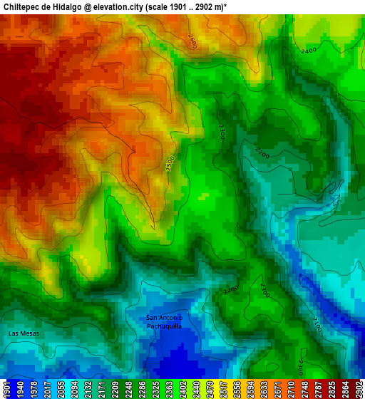
Below is the Elevation map of Chiltepec de Hidalgo, which displays elevation range with different colors. Scale of the first map is from 1901 to 2902 m (6237 to 9521 ft) with average elevation of 2358.3 meters (=7737 ft) [note 1]
These maps also provides idea of topography and contour of this city, they are displayed at different zoom levels. More info about maps, scale and edge coordinates you can find below images.
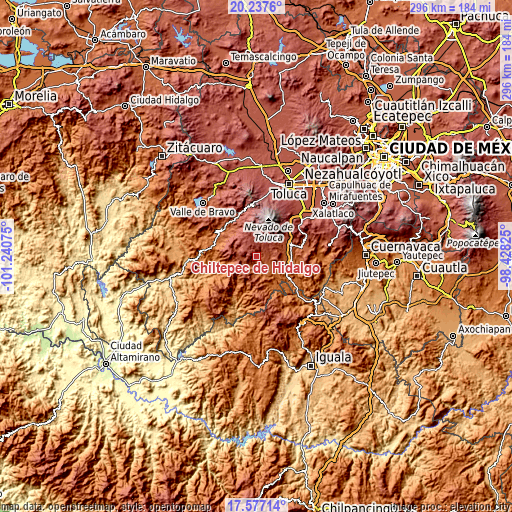
| \ | Map #1 | Topo.Map |
| Scale [m] | 1901..2902 m | × |
| Scale [ft] | 6237..9521 ft | × |
| Average | 2358.3 m = 7737 ft | × |
| Width | 9.24 km = 5.7 mi | 295.8 km = 183.8 mi |
| Height | 9.24 km = 5.7 mi | 295.8 km = 183.8 mi |
| ↑Max Latitude | 18.954228° | 20.2376° |
| Latitude at center | 18.91266° | 18.91266° |
| ↓Min Latitude | 18.871082° | 17.57714° |
| ← Min Longitude | -99.878445° | -101.24075° |
| Longitude center | -99.8345° | -99.8345° |
| →Max Longitude | -99.790555° | -98.42825° |
Nearby cities:
Cities around Chiltepec de Hidalgo sort by population:
• Coatepec Harinas elevation 2446 m
12 km,  99°
99°
• Almoloya de Alquisiras 1968 m
8.2 km,  230°
230°
• Texcaltitlán 2415 m
11.1 km,  280°
280°
• San Andrés Tepetitlán 2269 m
9.1 km,  259°
259°
• Acuitlapilco 2172 m
5.3 km,  94°
94°
• Primera de Analco 2142 m
6.3 km, 100°
• San Agustín 2380 m
11.5 km,  286°
286°
• Texcapilla 2900 m
7.4 km,  299°
299°
• Porfirío Díaz 2449 m
11.5 km,  81°
81°
• Ahuacatitlán 2299 m
13.4 km, 98°
• Llano Grande 1887 m
11.8 km,  143°
143°
• San José del Progreso 2348 m
5.1 km,  61°
61°
Multilingual:
 En español:
Chiltepec de Hidalgo elevación 2400 m.
 En France:
Chiltepec de Hidalgo élévation 2400 m.
 Auf Deutsch:
Chiltepec de Hidalgo höhe über dem Meeresspiegel ist 2400 m.
 На русском:
Chiltepec de Hidalgo высота над уровнем моря 2400 м
Sources and notes:
- [note 1] Map square and city borders are not equal. Map elevation data is calculated only from area inside that square.
- [src 1] Elevation data from geonames database provided with same terms of usage.
- [src 2] The elevation map of Chiltepec de Hidalgo is generated using elevation data from NASA's 3 arcsec (90m) resolution SRTM data.
- [src 3] Base (background) map © OpenStreetMap contributors tiles are generated by Geofabrik and OpenTopoMap.
Copyright & License:
This Chiltepec de Hidalgo Elevation Map is licensed under CC BY-SA. You may reuse any part from this page, if you give a proper credit by linking to this URL:
 More info on terms of use page.