Coatepec Harinas elevation
Coatepec Harinas (State of Mexico, Ixtapan de la Sal), Mexico elevation is 2446 meters and Coatepec Harinas elevation in feet is 8025 ft above sea level [src 1]. Coatepec Harinas is a populated place (feature code) with elevation that is 1132 meters (3714 ft) bigger than average city elevation in Mexico.
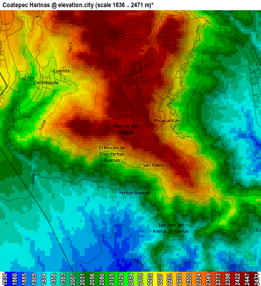
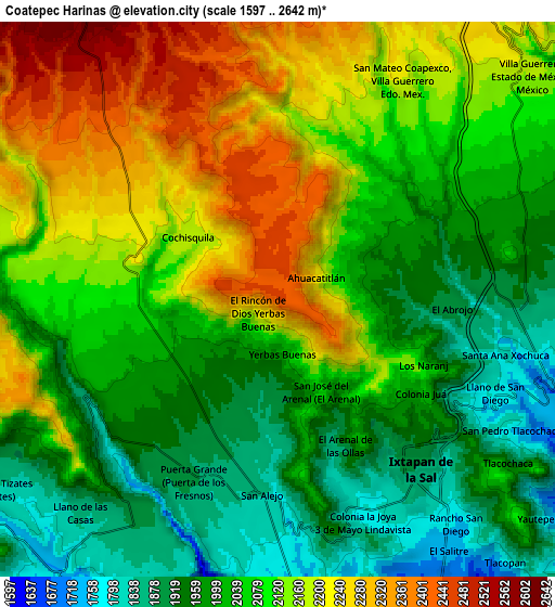
Below is the Elevation map of Coatepec Harinas, which displays elevation range with different colors. Scale of the first map is from 1836 to 2471 m (6024 to 8107 ft) with average elevation of 2134.4 meters (=7003 ft) [note 1]
These maps also provides idea of topography and contour of this city, they are displayed at different zoom levels. More info about maps, scale and edge coordinates you can find below images.
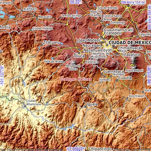
| \ | Map #1 | Map #2 | Topo.Map |
| Scale [m] | 1836..2471 m | 1597..2642 m | × |
| Scale [ft] | 6024..8107 ft | 5240..8668 ft | × |
| Average | 2134.4 m = 7003 ft | 2076.2 m = 6812 ft | × |
| Width | 9.25 km = 5.7 mi | 18.49 km = 11.5 mi | 295.8 km = 183.8 mi |
| Height | 9.25 km = 5.7 mi | 18.49 km = 11.5 mi | 295.9 km = 183.9 mi |
| ↑Max Latitude | 18.936492° | 18.978054° | 20.22° |
| Latitude at center | 18.89492° | 18.89492° | 18.89492° |
| ↓Min Latitude | 18.853338° | 18.811745° | 17.55927° |
| ← Min Longitude | -99.765475° | -99.809421° | -101.12778° |
| Longitude center | -99.72153° | -99.72153° | -99.72153° |
| →Max Longitude | -99.677585° | -99.633639° | -98.31528° |
Nearby cities:
Cities around Coatepec Harinas sort by population:
• Ixtapan de la Sal elevation 1871 m
7.4 km,  140°
140°
• Zacango 2198 m
7.2 km,  19°
19°
• Totolmajac 2043 m
5.2 km,  46°
46°
• Tecomatepec 1819 m
6.5 km,  163°
163°
• Acuitlapilco 2172 m
6.8 km,  283°
283°
• Primera de Analco 2142 m
5.7 km, 278°
• San Gaspar 2197 m
6.7 km, 18°
• Porfirío Díaz 2449 m
3.8 km,  351°
351°
• San Alejo 1851 m
6.3 km,  187°
187°
• Ahuacatitlán 2299 m
1.4 km,  93°
93°
• Colonia 3 de Mayo 1790 m
8.1 km, 158°
• San Miguel Laderas 2191 m
2.9 km,  116°
116°
Multilingual:
 En español:
Coatepec Harinas elevación 2446 m.
 En France:
Coatepec Harinas élévation 2446 m.
 Auf Deutsch:
Coatepec Harinas höhe über dem Meeresspiegel ist 2446 m.

Sources and notes:
- [note 1] Map square and city borders are not equal. Map elevation data is calculated only from area inside that square.
- [src 1] Elevation data from geonames database provided with same terms of usage.
- [src 2] The elevation map of Coatepec Harinas is generated using elevation data from NASA's 3 arcsec (90m) resolution SRTM data.
- [src 3] Base (background) map © OpenStreetMap contributors tiles are generated by Geofabrik and OpenTopoMap.
Copyright & License:
This Coatepec Harinas Elevation Map is licensed under CC BY-SA. You may reuse any part from this page, if you give a proper credit by linking to this URL:
 More info on terms of use page.